Country:
Region:
City:
Latitude and Longitude:
Time Zone:
Postal Code:
IP information under different IP Channel
ip-api
Country
Region
City
ASN
Time Zone
ISP
Blacklist
Proxy
Latitude
Longitude
Postal
Route
Luminati
Country
ASN
Time Zone
Europe/Oslo
ISP
Globalconnect As
Latitude
Longitude
Postal
IPinfo
Country
Region
City
ASN
Time Zone
ISP
Blacklist
Proxy
Latitude
Longitude
Postal
Route
db-ip
Country
Region
City
ASN
Time Zone
ISP
Blacklist
Proxy
Latitude
Longitude
Postal
Route
ipdata
Country
Region
City
ASN
Time Zone
ISP
Blacklist
Proxy
Latitude
Longitude
Postal
Route
Popular places and events near this IP address

Heggedal
Village in Østlandet, Norway
Distance: Approx. 841 meters
Latitude and longitude: 59.78333333,10.45
Heggedal is a part of the Asker municipality in Akershus county, Norway. For statistical purposes, it's usually treated as part of the Oslo urban area. [1] In 2000, its population was 3,301 [2], and the election district named Heggedal had 2,329 registered voters in the 2005 election.
Vollen, Asker
Village in Østlandet, Norway
Distance: Approx. 3246 meters
Latitude and longitude: 59.8075,10.48527778
Vollen is a part of the Asker municipality in Akershus county, Norway. For statistical purposes, it is usually treated as part of the Oslo urban area. It is mainly a residential area, though the area has a café, a restaurant, several art galleries, a primary school and secondary school.

Bødalen, Asker
Distance: Approx. 2902 meters
Latitude and longitude: 59.76666667,10.46666667
Bødalen is a village in Røyken in Asker municipality of Akershus, Norway. Bødalen is situated adjacent to Slemmestad. It is located about 35 km south of Oslo and 25 kilometers east of Drammen.

Slemmestad
Distance: Approx. 3405 meters
Latitude and longitude: 59.78333333,10.5
Slemmestad is a village in Røyken in Asker municipality in Akershus, Norway. Slemmestad is located on the west bank of the Oslofjord, west of Oslo.

Hallenskog Station
Railway station in Røyken, Norway
Distance: Approx. 2007 meters
Latitude and longitude: 59.77444444,10.41944444
Hallenskog Station (Norwegian: Hallenskog holdeplass) is a closed railway station located at Hallenskog in Asker, Norway on the Spikkestad Line. The station was opened as part of the Drammen Line in 1959, but in 1973 the new Lieråsen Tunnel opened through Lieråsen, and the old part of the Drammen Line was transformed to a commuter train line. The station was served by the Oslo Commuter Rail to Oslo Central Station and onward to Lillestrøm.

Heggedal Station
Railway station in Asker, Norway
Distance: Approx. 568 meters
Latitude and longitude: 59.78694444,10.43111111
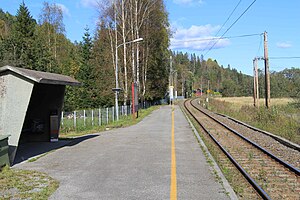
Heggedal Station (Norwegian: Heggedal stasjon) is a railway station located at Heggedal in Asker, Norway on the Spikkestad Line. Heggedal station is located around 99.2 meters above sea level and 29.34 km from Oslo Central Station.

Gullhella Station
Railway station in Asker, Norway
Distance: Approx. 1968 meters
Latitude and longitude: 59.80666667,10.43638889
Gullhella Station (Norwegian: Gullhella holdeplass) is a railway station located at Gullhella in Asker, Norway on the Spikkestad Line. The station was opened as part of the Drammen Line on 15 July 1937, but in 1973 the new Lieråsen Tunnel opened through Lieråsen, and the old part of the Drammen Line was transformed to a commuter train line. The station is served by Oslo Commuter Rail trains to Oslo Central Station and onward to Lillestrøm Station.
Bjerkås
Village in Østlandet, Norway
Distance: Approx. 2576 meters
Latitude and longitude: 59.7925,10.4858
Bjerkås is a village in Asker municipality, Norway.
Gullhella
Village in Østlandet, Norway
Distance: Approx. 2332 meters
Latitude and longitude: 59.81,10.44305556
Gullhella is a village in Asker, Akershus, Norway.
Håkavik
Village in Østlandet, Norway
Distance: Approx. 3407 meters
Latitude and longitude: 59.8029,10.4946
Håkavik is a village in Asker, Akershus, Norway.
Sjøstrand, Asker
Village in Østlandet, Norway
Distance: Approx. 3027 meters
Latitude and longitude: 59.7975,10.4917
Sjøstrand is a fishing village in Asker, Akershus, Norway.
Solberg, Akershus
Village in Østlandet, Norway
Distance: Approx. 3256 meters
Latitude and longitude: 59.80305,10.3892
Solberg is a farm in Asker, Akershus, Norway.
Weather in this IP's area
broken clouds
3 Celsius
2 Celsius
1 Celsius
4 Celsius
1016 hPa
75 %
1016 hPa
1003 hPa
10000 meters
1.36 m/s
1.21 m/s
306 degree
75 %
08:13:10
15:52:29