Country:
Region:
City:
Latitude and Longitude:
Time Zone:
Postal Code:
IP information under different IP Channel
ip-api
Country
Region
City
ASN
Time Zone
ISP
Blacklist
Proxy
Latitude
Longitude
Postal
Route
Luminati
Country
Region
ct
City
palamos
ASN
Time Zone
Europe/Madrid
ISP
Sambatel Consulting Sl
Latitude
Longitude
Postal
IPinfo
Country
Region
City
ASN
Time Zone
ISP
Blacklist
Proxy
Latitude
Longitude
Postal
Route
db-ip
Country
Region
City
ASN
Time Zone
ISP
Blacklist
Proxy
Latitude
Longitude
Postal
Route
ipdata
Country
Region
City
ASN
Time Zone
ISP
Blacklist
Proxy
Latitude
Longitude
Postal
Route
Popular places and events near this IP address

Palamós
Municipality in Catalonia, Spain
Distance: Approx. 560 meters
Latitude and longitude: 41.85,3.12916667
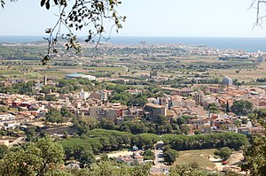
Palamós (Catalan pronunciation: [pələˈmos]) is a town and municipality in the Mediterranean Costa Brava, located in the comarca of Baix Empordà, in the province of Girona, Catalonia, Spain. Palamós is located at the northern end of a large bay. The town is by-passed by the C31 which connects the coastal towns of the central Costa Brava with Girona.
Battle of Les Formigues
1285 naval battle near Spain
Distance: Approx. 4888 meters
Latitude and longitude: 41.85,3.18333333
The naval Battle of Les Formigues (Catalan) took place probably in the early morning of 4 September 1285 near Les Formigues Islands, Catalonia, about 85 km northeast of Barcelona, when a Catalan-Sicilian galley fleet commanded by Roger of Lauria defeated a French and Genoese galley fleet commanded by Guilhem de Lodeva, Henry di Mari, and John de Orrea. There are three almost completely different accounts of this battle: from Ramon Muntaner, Bernard Desclot, and the Gesta comitum Barchinonensium. The Gesta places the battle at Les Formigues (or Fomigas), while Muntaner favoured a location off Roses to the north.

Calonge
Municipality in Catalonia, Spain
Distance: Approx. 4385 meters
Latitude and longitude: 41.8625,3.07638889
Calonge (Catalan pronunciation: [kəˈlɔɲʒə]) is a municipality in the comarca of the Baix Empordà in Catalonia, Spain, on the coastline of the Costa Brava. The town comprises two parts, a medieval hill village and modern seaside resort. The main urban centre and original village is about 4 km inland from the Bay of Sant Antoni.

Castell de la Fosca
Distance: Approx. 3241 meters
Latitude and longitude: 41.86027778,3.15888889
Castell de la Fosca or Punta del Castell is an ancient Iberian settlement or oppidum sited on a rocky promontory at the north end of the beach called Platja de Castell, about 2 kilometres (1.2 mi) ENE of Palamós (Baix Empordà), on the Costa Brava. The settlement, which seems to have been inhabited from the 6th century BC to the 1st century AD, was protected by a wall and two square towers. Archaeologists, first in the 1930s and 1940s, and now in a series of excavations begun in 2001, have discovered 64 storage pits and two water cisterns, as well as pottery, amphorae (both locally made and imported), millstones, weights for fishing nets, lamps, agricultural tools and surgical instruments, coins, pieces of bronze, Iberian inscriptions, and the bases of two columns.

Vall-llobrega
Municipality in Catalonia, Spain
Distance: Approx. 4186 meters
Latitude and longitude: 41.88333333,3.13333333
Vall-llobrega (Catalan pronunciation: [ˌbaʎ.ʎuˈβɾɛɣə]) is a village and municipality in the province of Girona and autonomous community of Catalonia, Spain. The first evidence of human settlement in the Vall-llobrega area is the Dolmen de Montagut, on the top of Montagut hill between Vall-llobrega and Palamós. Dating from the 3rd or 2nd millennium BC, this has 3 slabs in their original state and the remains of a tomb that these once covered.

Formigues Islands
Distance: Approx. 5453 meters
Latitude and longitude: 41.8625,3.18666667
The Formigues Islands (Catalan: Illes Formigues, Spanish: Islas Formigues) is an archipelago consisting of 16 small islands located three miles (4.8 km)from the port of Palamós, Girona Province, Catalonia, Spain. They lie facing the beach of Calella and Cap Roig. A lighthouse is located on the island of Formiga Gran (41º53'N 03º11'E).

Sant Antoni de Calonge
Town in Catalonia, Spain
Distance: Approx. 2132 meters
Latitude and longitude: 41.84638889,3.09888889
Sant Antoni de Calonge is a town which forms part of the city of Calonge. It is located in the comarca of the Baix Empordà in Catalonia, Spain. The town was built along the rocky coastline of northern Spain.

La Fosca
Neighbourhood in Girona, Catalonia, Spain
Distance: Approx. 1871 meters
Latitude and longitude: 41.857,3.142
La Fosca is a neighbourhood of the town of Palamós and a beach on the Costa Brava, located in the comarca of Baix Empordà and the province of Girona in Catalonia, Spain. La Fosca is situated between the port of Palamós and the fishing settlement of S'Alguer. The town is by-passed by the C31 which connects the coastal towns of the central Costa Brava with Girona.

Estadi Palamós Costa Brava
Distance: Approx. 856 meters
Latitude and longitude: 41.85361111,3.12138889
The Estadi Municipal Palamós Costa Brava is a multi-use stadium located in Palamós, Catalonia, Spain.

Fishing Museum, Palamós
Museum in Palamós, Spain
Distance: Approx. 226 meters
Latitude and longitude: 41.84508,3.12678
Opened in 2002, the Fishing Museum is dedicated to fishing knowledge and dissemination, and Costa Brava's maritime heritage. Located in the Palamós fishing port in an old warehouse called "Tinglado", the permanent exhibition explains the history, current affairs and sustainable fishing in Costa Brava's future. The Fundació Promediterrània manages the Fishing Museum, a municipal facility.

Castell de Sant Esteve de Mar
Cultural property in Palamós, Spain
Distance: Approx. 2322 meters
Latitude and longitude: 41.8583,3.1475
The Castell de Sant Esteve de Mar is a ruined castle perched atop a cliff in the town of Palamós, in Baix Empordà, between La Fosca and the Cala s'Alguer. Only the bases of some towers and some walls remain, and is currently surrounded by a fence that prevents access to visitors. It is accessed from the path leading from the beach of Fosca to S'Alguer that forms part of the GR 92 long distance footpath.

Cala s'Alguer
Fishing village in Catalonia, Spain
Distance: Approx. 1871 meters
Latitude and longitude: 41.857,3.142
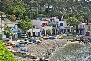
The Cala s'Alguer is a traditional fishing village on the Costa Brava coast of Catalonia, Spain. It is part of the municipality of Palamós, in the comarca of Baix Empordà and the province of Girona. The historical complex has been declared a cultural asset of national interest.
Weather in this IP's area
overcast clouds
12 Celsius
10 Celsius
9 Celsius
12 Celsius
1024 hPa
53 %
1024 hPa
1024 hPa
10000 meters
2.24 m/s
3.58 m/s
355 degree
89 %
07:36:14
17:27:57