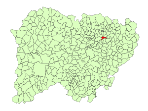
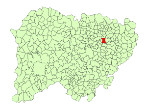
Country:
Region:
City:
Latitude and Longitude:
Time Zone:
Postal Code:
IP information under different IP Channel
ip-api
Country
Region
City
ASN
Time Zone
ISP
Blacklist
Proxy
Latitude
Longitude
Postal
Route
Luminati
Country
Region
cl
City
calvarrasadeabajo
ASN
Time Zone
Europe/Madrid
ISP
Setel Conecta S.l.
Latitude
Longitude
Postal
IPinfo
Country
Region
City
ASN
Time Zone
ISP
Blacklist
Proxy
Latitude
Longitude
Postal
Route
db-ip
Country
Region
City
ASN
Time Zone
ISP
Blacklist
Proxy
Latitude
Longitude
Postal
Route
ipdata
Country
Region
City
ASN
Time Zone
ISP
Blacklist
Proxy
Latitude
Longitude
Postal
Route
Popular places and events near this IP address

Salamanca Airport
Airport
Distance: Approx. 3769 meters
Latitude and longitude: 40.95194444,-5.50194444
Salamanca Airport (IATA: SLM, ICAO: LESA) is the airport serving the province of Salamanca in the autonomous community of Castile and León. It is located in the municipalities of Machacón, Calvarrasa de Abajo y Villagonzalo de Tormes; and it is 15 km from Salamanca city.

Aldealengua
Municipality in Castile and León, Spain
Distance: Approx. 4125 meters
Latitude and longitude: 40.98222222,-5.55
Aldealengua is a village and municipality in the north-west of the province of Salamanca, western Spain, part of the autonomous community of Castile and León.

Calvarrasa de Abajo
Municipality in Castile and León, Spain
Distance: Approx. 627 meters
Latitude and longitude: 40.95,-5.55
Calvarrasa de Abajo is a village and municipality in the province of Salamanca, western Spain, part of the autonomous community of Castile-Leon. It is 10 kilometres (6.2 mi) from the provincial capital city of Salamanca and has a population of 1,143 people. The municipality covers an area of 28 km2 (11 sq mi).

Calvarrasa de Arriba
Municipality in Castile and León, Spain
Distance: Approx. 2228 meters
Latitude and longitude: 40.92666667,-5.55555556
Calvarrasa de Arriba is a village and municipality in the province of Salamanca, western Spain, part of the autonomous community of Castile-Leon. It is 10 kilometres (6.2 mi) from the provincial capital city of Salamanca and has a population of 604 people. The municipality covers an area of 26 km2 (10 sq mi).

Cabrerizos
Municipality in Castile and León, Spain
Distance: Approx. 6769 meters
Latitude and longitude: 40.97916667,-5.61277778
Cabrerizos is a village and municipality in the province of Salamanca, western Spain, part of the autonomous community of Castile-Leon. It is located only 4 kilometres (2.5 mi) from the city of Salamanca and has a population of 4205 people. The municipality covers an area of 12 km2, lying 826 metres (2,710 ft) above sea level and the postal code is 37193.

Santa Marta de Tormes
Municipality in Castile and León, Spain
Distance: Approx. 7296 meters
Latitude and longitude: 40.94944444,-5.6325
Santa Marta de Tormes (Saint Martha upon Tormes) is a municipality in the province of Salamanca, western Spain, part of the autonomous community of Castile and León, on the outskirts of the capital Salamanca, located only 3 kilometers away. It is part of the Campo de Salamanca region (Campo Charro), and belongs to the judicial district of Salamanca. Its municipal area is made up of a single population center, which occupies a total of 10.01 km^2.

Encinas de Abajo
Municipality in Castile and León, Spain
Distance: Approx. 6795 meters
Latitude and longitude: 40.93333333,-5.46666667
Encinas de Abajo is a village and municipality in the province of Salamanca, Spain, which is part of the autonomous community of Castile-Leon. It is located 17 kilometres (11 mi) from the provincial capital city of Salamanca, and had a population in 2016 of 666.

Machacón
Municipality in Castile and León, Spain
Distance: Approx. 2749 meters
Latitude and longitude: 40.92666667,-5.52444444
Machacón is a municipality located in the province of Salamanca, Castile and León, Spain. As of 2016 the municipality has a population of 453 inhabitants.

Pelabravo
Municipality in Castile and León, Spain
Distance: Approx. 3091 meters
Latitude and longitude: 40.93666667,-5.58083333
Pelabravo is a municipality located in the province of Salamanca, Castile and León, Spain. As of 2016 the municipality has a population of 818 inhabitants.

San Morales
Municipality in Castile and León, Spain
Distance: Approx. 6434 meters
Latitude and longitude: 40.99305556,-5.50277778
San Morales is a municipality located in the province of Salamanca, Castile and León, Spain. As of 2016 the municipality has a population of 306 inhabitants.

Villagonzalo de Tormes
Municipality in Castile and León, Spain
Distance: Approx. 7123 meters
Latitude and longitude: 40.8925,-5.49805556
Villagonzalo de Tormes is a municipality located in the province of Salamanca, Castile and León, Spain. As of 2016, the municipality has recorded a population of 222 inhabitants.

Huerta, Salamanca
Municipality in Castile and León, Spain
Distance: Approx. 6952 meters
Latitude and longitude: 40.96805556,-5.46888889
Huerta is a municipality located in the province of Salamanca, Castile and León, Spain.
Weather in this IP's area
light rain
12 Celsius
11 Celsius
7 Celsius
12 Celsius
1018 hPa
87 %
1018 hPa
925 hPa
8000 meters
2.06 m/s
160 degree
95 %
08:10:00
18:03:54