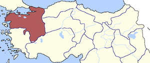
Country:
 Turkey
Region:
City:
Latitude and Longitude:
Time Zone:
Postal Code:
IP information under different IP Channel
ip-api
Country
Region
City
ASN
Time Zone
ISP
Blacklist
Proxy
Latitude
Longitude
Postal
Route
IPinfo
Country
Region
City
ASN
Time Zone
ISP
Blacklist
Proxy
Latitude
Longitude
Postal
Route
MaxMind
Country
Region
City
ASN
Time Zone
ISP
Blacklist
Proxy
Latitude
Longitude
Postal
Route
Luminati
Country
TRASN
Time Zone
Europe/Istanbul
ISP
Sistemdc webhosting and server services
Latitude
Longitude
Postal
db-ip
Country
Region
City
ASN
Time Zone
ISP
Blacklist
Proxy
Latitude
Longitude
Postal
Route
ipdata
Country
Region
City
ASN
Time Zone
ISP
Blacklist
Proxy
Latitude
Longitude
Postal
Route
Popular places and events near this IP address

Bursa
City in Bursa province in western Turkey
Distance: Approx. 1098 meters
Latitude and longitude: 40.18333333,29.05
Bursa (Turkish pronunciation: [ˈbuɾsa]) is a city in northwestern Turkey and the administrative center of Bursa Province. The fourth-most populous city in Turkey and second-most populous in the Marmara Region, Bursa is one of the industrial centers of the country. Most of Turkey's automotive production takes place in Bursa.

Osmangazi
District and municipality in Bursa, Turkey
Distance: Approx. 1098 meters
Latitude and longitude: 40.19833333,29.06
Osmangazi is a municipality and district of Bursa Province, Turkey. Its area is 621 km2, and its population is 891,250 (2022). It is one of the central metropolitan districts of the city of Bursa, as well as the fourth largest overall municipality in Turkey.

Bursaray
Rapid transit system of Bursa, Turkey
Distance: Approx. 1098 meters
Latitude and longitude: 40.18333333,29.05
Bursaray (sometimes stylized as BursaRay) is a rapid transit system in the city of Bursa, Marmara Region, Turkey, built in 2000 by TÜVASAŞ, and operated by Burulaş. The name Bursaray is a portmanteau of Bursa, and Ray, the Turkish word for "rail". The Bursaray metro opened for passenger service on 24 April 2002.

Siege of Bursa
1317–1326 capture of the Byzantine city of Prusa by the Ottoman Empire
Distance: Approx. 755 meters
Latitude and longitude: 40.1833,29.0667
The siege of Bursa occurred from 1317 until the capture on 6 April 1326, when the Ottomans deployed a bold plan to seize Prusa (modern-day Bursa, Turkey). The Ottomans had not captured a city before; the lack of expertise and adequate siege equipment at this stage of the war meant that the city fell only after six or nine years. The historian, Laonikos Chalkokondyles, notes that the Ottomans took advantage of the Byzantine civil war of 1321–1328 to capture the city: "Andronikos decided that he should hold the throne himself, as his grandfather had already grown old, and so they fell out with each other.

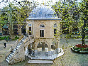
Grand Mosque of Bursa
14th-century Ottoman-era mosque in northwestern Turkey
Distance: Approx. 516 meters
Latitude and longitude: 40.18388889,29.06166667
The Grand Mosque of Bursa (Turkish: Bursa Ulu Cami) is a historic mosque in Bursa, Turkey. It was commissioned by the Ottoman Sultan Bayezid I to commemorate his great victory at the Battle of Nicopolis and built between 1396 and 1399. The mosque is a major monument of early Ottoman architecture and one of the most important mosques in the city, located in the heart of the old city alongside its historic markets.
Hüdavendigâr Eyalet
Administrative division of the Ottoman Empire from 1827 to 1867
Distance: Approx. 1098 meters
Latitude and longitude: 40.18333333,29.05
Hüdavendigâr Eyalet (Ottoman Turkish: ایالت خداوندگار, romanized: Eyālet-i Ḥüdāvendigār) was an eyalet of the Ottoman Empire. The word Hüdavendigâr comes from the Persian word Khodāvandgār which literally translates to "devotee of god".

Veled-i Yaniç Mosque
Mosque in Bursa, Turkey
Distance: Approx. 551 meters
Latitude and longitude: 40.185,29.05642
Veled-i Yaniç Mosque (Turkish: Veled-i Yaniç Camiii) is an Ottoman mosque with the type of early Ottoman architecture. The mosque is located in Bursa, Turkey and it is still in use. According to the inscription, which is above the entering door, it is known that this mosque was built at the July 1440 by Mahmud Çelebi.

2016 Bursa bombing
Terrorist incident in Turkey
Distance: Approx. 516 meters
Latitude and longitude: 40.1839,29.0617
On 27 April 2016, a suicide bombing took place in the Turkish city of Bursa. The bombing took place at 17:26 (UTC+3), near the western entrance of the Grand Mosque and a covered market. One person, the suicide bomber, was killed and 13 people were injured.
Prusa (Bithynia)
Historic town of ancient Bithynia or of Mysia
Distance: Approx. 412 meters
Latitude and longitude: 40.184818,29.061495
Prusa or Prousa (Ancient Greek: Προῦσα), or Prusa near Olympus or Prusa under Olympus (Προῦσα ἐπὶ τῷ Ὀλύμπῳ, Προῦσα πρὸς τῷ Ὀλύμπῳ), was a town of ancient Bithynia or of Mysia, situated at the northern foot of Mysian Olympus. Pliny the Elder states that the town was built by Hannibal during his stay with Prusias I, which can only mean that it was built by Prusias, whose name it bears, on the advice of Hannibal. It is acknowledged by Dion Chrysostomus, who was a native of the town in the first and second centuries, that it was neither very ancient nor very large.
Koza Han
Caravanserai in Bursa, Turkey
Distance: Approx. 511 meters
Latitude and longitude: 40.18433333,29.06352778
The Koza Han (Turkish: Koza Hanı, lit. 'inn of the silk cocoon') is a historic caravanserai (han) in Bursa, Turkey. It is located in the heart of the city's historic market district.
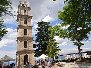
Tophane Clock Tower
Distance: Approx. 311 meters
Latitude and longitude: 40.18756,29.05755
The Tophane Clock Tower (Turkish: Tophane Saat Kulesi) is a clock tower in Bursa, Turkey. It has six floors and is 33m in height. The tower currently has a radio clock and is used as a fire lookout station.
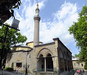
Orhan Gazi Mosque
Historic mosque in Bursa, Turkey
Distance: Approx. 580 meters
Latitude and longitude: 40.18388889,29.06416667
The Orhan Gazi Mosque (Turkish: Orhan Gazi Camii) is a historic mosque in Bursa, Turkey. It is named after the Ottoman ruler Orhan, who founded the mosque in 1339–40 as part of a larger charitable complex. It is one of the oldest surviving monuments commissioned by the Ottoman dynasty.
Weather in this IP's area
scattered clouds
21 Celsius
20 Celsius
21 Celsius
21 Celsius
1011 hPa
38 %
1011 hPa
987 hPa
10000 meters
0.64 m/s
2.05 m/s
312 degree
49 %
07:09:10
18:31:54