Country:
 Turkey
Region:
City:
Latitude and Longitude:
Time Zone:
Postal Code:
IP information under different IP Channel
ip-api
Country
Region
City
ASN
Time Zone
ISP
Blacklist
Proxy
Latitude
Longitude
Postal
Route
IPinfo
Country
Region
City
ASN
Time Zone
ISP
Blacklist
Proxy
Latitude
Longitude
Postal
Route
MaxMind
Country
Region
City
ASN
Time Zone
ISP
Blacklist
Proxy
Latitude
Longitude
Postal
Route
Luminati
Country
TRASN
Time Zone
Europe/Istanbul
ISP
Sistemdc webhosting and server services
Latitude
Longitude
Postal
db-ip
Country
Region
City
ASN
Time Zone
ISP
Blacklist
Proxy
Latitude
Longitude
Postal
Route
ipdata
Country
Region
City
ASN
Time Zone
ISP
Blacklist
Proxy
Latitude
Longitude
Postal
Route
Popular places and events near this IP address
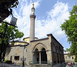
Green Mosque, Bursa
Mosque in Bursa, Turkey
Distance: Approx. 1049 meters
Latitude and longitude: 40.18194444,29.07444444
The Green Mosque (Turkish: Yeşil Camii), also known as the Mosque of Mehmed I, is a part of a larger complex (külliye) on the east side of Bursa, Turkey, the former capital of the Ottoman Turks before they captured Constantinople in 1453. The complex consists of a mosque, a mausoleum known as the Green Tomb, a madrasa, a public kitchen, and a bathhouse. The name Green Mosque comes from its green and blue interior tile decorations.

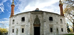
Bayezid I Mosque
Mosque in Bursa, Turkey
Distance: Approx. 1693 meters
Latitude and longitude: 40.1875,29.0825
Bayezid I Mosque (Turkish: Yıldırım Camii or Yıldırım Bayezid Camii) is a historic mosque in Bursa, Turkey, that is part of the large complex (külliye) built by the Ottoman Sultan Bayezid I (Yıldırım Bayezid – Bayezid the Thunderbolt) between 1391–1395. It is situated in Bursa metropolitan district of Yıldırım, also named after the same sultan. It underwent extensive renovation following the 1855 Bursa earthquake.
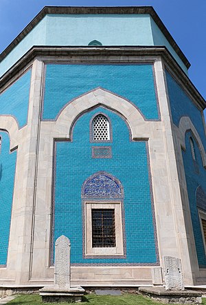
Green Tomb
Mausoleum in Turkey
Distance: Approx. 983 meters
Latitude and longitude: 40.18138889,29.07472222
The Green Tomb (Turkish: Yeşil Türbe) is a mausoleum of the fifth Ottoman Sultan, Mehmed I, in Bursa, Turkey. It was built by Mehmed's son and successor Murad II following the death of the sovereign in 1421. The architect Hacı Ivaz Pasha designed the tomb and the Yeşil Mosque opposite to it.

Emir Sultan Mosque
Mosque in Bursa, Turkey
Distance: Approx. 970 meters
Latitude and longitude: 40.18111111,29.08083333
The Emir Sultan Mosque (Turkish: Emir Sultan Camii) is in Bursa, Turkey. First built in the 15th century, it was rebuilt in 1804 for the Ottoman sultan Selim III, and rebuilt again in 1868, the plan of the mosque changing slightly with each rebuild.

Siege of Bursa
1317–1326 capture of the Byzantine city of Prusa by the Ottoman Empire
Distance: Approx. 1481 meters
Latitude and longitude: 40.1833,29.0667
The siege of Bursa occurred from 1317 until the capture on 6 April 1326, when the Ottomans deployed a bold plan to seize Prusa (modern-day Bursa, Turkey). The Ottomans had not captured a city before; the lack of expertise and adequate siege equipment at this stage of the war meant that the city fell only after six or nine years. The historian, Laonikos Chalkokondyles, notes that the Ottomans took advantage of the Byzantine civil war of 1321–1328 to capture the city: "Andronikos decided that he should hold the throne himself, as his grandfather had already grown old, and so they fell out with each other.
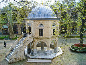
Bursa Museum of Turkish and Islamic Art
Museum in Bursa, Turkey
Distance: Approx. 1043 meters
Latitude and longitude: 40.1816,29.0732
The Bursa Museum of Turkish and Islamic Art (Turkish: Bursa Türk ve İslam Eserleri Müzesi) is a museum located in the former medrese of Yeşil Complex, which was constructed within the order of the Ottoman Sultan Mehmed I in 1419.

Tofaş Museum of Cars and Anatolian Carriages
Transport museum in Bursa, Turkey
Distance: Approx. 689 meters
Latitude and longitude: 40.17694444,29.07138889
The Tofaş Museum of Cars and Anatolian Carriages (Turkish: Tofaş Anadolu Arabaları Müzesi) is a private transport museum in Bursa, Turkey owned by the Turkish automobile maker Tofaş and dedicated to various carriages (Turkish: Araba) from Turkey and Tofaş-manufactured cars. It was opened on June 30, 2002. Situated in the historic Umurbey neighborhood of Yıldırım district, the museum is housed in a renovated building of 17,000 m2 (180,000 sq ft) that was an abandoned silk production plant.

2016 Bursa bombing
Terrorist incident in Turkey
Distance: Approx. 1819 meters
Latitude and longitude: 40.1839,29.0617
On 27 April 2016, a suicide bombing took place in the Turkish city of Bursa. The bombing took place at 17:26 (UTC+3), near the western entrance of the Grand Mosque and a covered market. One person, the suicide bomber, was killed and 13 people were injured.

Irgandı Bridge
Bridge in Bursa, Turkey
Distance: Approx. 1140 meters
Latitude and longitude: 40.1818,29.071
Irgandı Bridge (Turkish: Irgandı Köprüsü) is an historical bridge in Bursa, Turkey.
Koza Han
Caravanserai in Bursa, Turkey
Distance: Approx. 1744 meters
Latitude and longitude: 40.18433333,29.06352778
The Koza Han (Turkish: Koza Hanı, lit. 'inn of the silk cocoon') is a historic caravanserai (han) in Bursa, Turkey. It is located in the heart of the city's historic market district.

Amir Sultan Cemetery
Cemetery in Bursa, Turkey
Distance: Approx. 1042 meters
Latitude and longitude: 40.18194444,29.08
Amir Sultan Cemetery is a historical cemetery located in Yıldırım district of Bursa. The cemetery is named after the Islamic philosopher Amir Sultan.
Orhan Gazi Mosque
Historic mosque in Bursa, Turkey
Distance: Approx. 1671 meters
Latitude and longitude: 40.18388889,29.06416667
The Orhan Gazi Mosque (Turkish: Orhan Gazi Camii) is a historic mosque in Bursa, Turkey. It is named after the Ottoman ruler Orhan, who founded the mosque in 1339–40 as part of a larger charitable complex. It is one of the oldest surviving monuments commissioned by the Ottoman dynasty.
Weather in this IP's area
overcast clouds
24 Celsius
23 Celsius
24 Celsius
24 Celsius
1009 hPa
40 %
1009 hPa
965 hPa
10000 meters
1.72 m/s
2.66 m/s
316 degree
97 %
07:09:06
18:31:51