185.250.200.198 - IP Lookup: Free IP Address Lookup, Postal Code Lookup, IP Location Lookup, IP ASN, Public IP
Country:
Region:
City:
Location:
Time Zone:
Postal Code:
ISP:
ASN:
language:
User-Agent:
Proxy IP:
Blacklist:
IP information under different IP Channel
ip-api
Country
Region
City
ASN
Time Zone
ISP
Blacklist
Proxy
Latitude
Longitude
Postal
Route
db-ip
Country
Region
City
ASN
Time Zone
ISP
Blacklist
Proxy
Latitude
Longitude
Postal
Route
IPinfo
Country
Region
City
ASN
Time Zone
ISP
Blacklist
Proxy
Latitude
Longitude
Postal
Route
IP2Location
185.250.200.198Country
Region
andalucia
City
rioja
Time Zone
Europe/Madrid
ISP
Language
User-Agent
Latitude
Longitude
Postal
ipdata
Country
Region
City
ASN
Time Zone
ISP
Blacklist
Proxy
Latitude
Longitude
Postal
Route
Popular places and events near this IP address

Los Millares
Chalcolithic occupation site in Spain
Distance: Approx. 5691 meters
Latitude and longitude: 36.96472222,-2.52222222
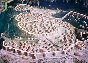
Los Millares is a Chalcolithic occupation site 17 km north of Almería, in the municipality of Santa Fe de Mondújar, Andalucía, Spain. The complex was in use from the fourth millennium BC (c. 3000 BC) to the end of the third millennium BC (2000 BC) and probably supported somewhere around 1000 people. It was discovered in 1891 during the construction of a railway.

Benahadux
Place in Andalusia, Spain
Distance: Approx. 2069 meters
Latitude and longitude: 36.92666667,-2.46138889
Benahadux (Spanish: [benaˈðu(ɣ)s]) is a municipality of Almería province, in the autonomous community of Andalusia, Spain.

Gádor
Place in Andalusia, Spain
Distance: Approx. 1878 meters
Latitude and longitude: 36.95,-2.48333333
Gádor is a municipality of Almería province, in the autonomous community of Andalusia, Spain. The murder of Bernardo Gonzalez Parra by Francisco Leona happened on 28 June 1910 in Gádor.

Huércal de Almería
Place in Andalusia, Spain
Distance: Approx. 7379 meters
Latitude and longitude: 36.88333333,-2.43333333
Huércal de Almería is a municipality of Almería province, in the autonomous community of Andalusia, Spain.

Pechina
Place in Andalusia, Spain
Distance: Approx. 4136 meters
Latitude and longitude: 36.91666667,-2.43333333
Pechina is a municipality of the Province of Almería, in the autonomous community of Andalusia, Spain. It is on the site of the ancient town of Urci. Pechina, called Bajjāna in Arabic, was the centre of a Yemeni colony during the period of the Umayyad caliphate in Spain.

Rioja, Almería
Place in Andalusia, Spain
Distance: Approx. 1762 meters
Latitude and longitude: 36.93333333,-2.45
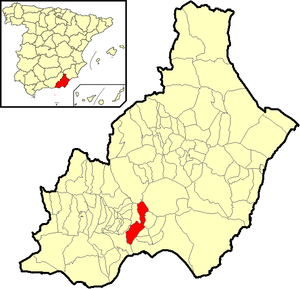
Rioja is a municipality of Almería province, in the autonomous community of Andalusia, Spain. It should not be confused with La Rioja (autonomous community) in the north, known for its distinctive wine.

Santa Fe de Mondújar
Place in Andalusia, Spain
Distance: Approx. 5331 meters
Latitude and longitude: 36.96666667,-2.51666667
Santa Fe de Mondújar is a municipality of the Province of Almería, in the autonomous community of Andalusia, Spain.

Viator
Place in Andalusia, Spain
Distance: Approx. 8032 meters
Latitude and longitude: 36.88333333,-2.41666667
Viator is a municipality of Almería province, in the autonomous community of Andalusia, Spain. José Brocca lived here.

Tabernas Desert
Desert in Spain
Distance: Approx. 6211 meters
Latitude and longitude: 37,-2.45
The Tabernas Desert (Spanish: Desierto de Tabernas) is a desert located within Spain's south-eastern province of Almería. It is in the interior, about 30 kilometers (19 mi) north of the provincial capital Almería, in the Tabernas municipality in Andalusia. It is the only desert in Europe, since most of its area has a desert climate.

Comarca Metropolitana de Almería
Comarca in Andalusia, Spain
Distance: Approx. 2128 meters
Latitude and longitude: 36.92611111,-2.46444444
Comarca Metropolitana de Almería is a comarca and metropolitan area in the province of Almería, Spain.

Crime of Gádor
1910 kidnapping and murder of a boy
Distance: Approx. 1290 meters
Latitude and longitude: 36.94111111,-2.47666667
The crime of Gádor was the name given to the 1910 kidnapping and subsequent murder of a seven-year-old boy by Francisco Leona in Gádor, Almería, Spain. The purpose of the crime was to use the child's blood and body fat as a folk cure for a wealthy patron's tuberculosis.
1804 Almería earthquake
Natural disaster affecting southern Spain
Distance: Approx. 7540 meters
Latitude and longitude: 36.9,-2.4
The 1804 Almería earthquake was a highly destructive seismic event in the Province of Almería, southern Spain. It occurred on 25 August at 8:25 pm local time. The mainshock had a maximum intensity assigned VIII–IX on the European macroseismic scale (EMS), and an estimated moment magnitude of 6.2–6.4 Mw .
Weather in this IP's area
clear sky
7 Celsius
4 Celsius
7 Celsius
7 Celsius
1029 hPa
42 %
1029 hPa
986 hPa
10000 meters
5.66 m/s
330 degree