Country:
 Germany
Region:
City:
Latitude and Longitude:
Time Zone:
Postal Code:
IP information under different IP Channel
ip-api
Country
Region
City
ASN
Time Zone
ISP
Blacklist
Proxy
Latitude
Longitude
Postal
Route
IPinfo
Country
Region
City
ASN
Time Zone
ISP
Blacklist
Proxy
Latitude
Longitude
Postal
Route
MaxMind
Country
Region
City
ASN
Time Zone
ISP
Blacklist
Proxy
Latitude
Longitude
Postal
Route
Luminati
Country
DERegion
sl
City
heusweiler
ASN
Time Zone
Europe/Berlin
ISP
SYBCOM GmbH
Latitude
Longitude
Postal
db-ip
Country
Region
City
ASN
Time Zone
ISP
Blacklist
Proxy
Latitude
Longitude
Postal
Route
ipdata
Country
Region
City
ASN
Time Zone
ISP
Blacklist
Proxy
Latitude
Longitude
Postal
Route
Popular places and events near this IP address
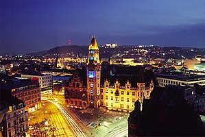
Saarbrücken
Capital of Saarland, Germany
Distance: Approx. 2641 meters
Latitude and longitude: 49.23333333,7
Saarbrücken (German: [zaːɐ̯ˈbʁʏkn̩] ; Rhenish Franconian: Sabrigge [zaːˈbʁɪɡə]; French: Sarrebruck [saʁbʁyk]; Luxembourgish: Saarbrécken [zaːˈbʀekən] ; Latin: Saravipons; lit. 'Saar Bridges') is the capital and largest city of the state of Saarland, Germany. Saarbrücken has 181,959 inhabitants and is Saarland's administrative, commercial and cultural centre. It is located on the Saar River (a tributary of the Moselle), directly borders the French department of Moselle, and is Germany's second-westernmost state capital after Düsseldorf.

Saarländischer Rundfunk
German public radio and television broadcaster
Distance: Approx. 16 meters
Latitude and longitude: 49.22305556,7.0325
Saarländischer Rundfunk (pronounced [ˈzaːɐ̯ˌlɛndɪʃɐ ˈʁʊntfʊŋk]; "Saarland Broadcasting"), shortened to SR (pronounced [ɛsˈʔɛʁ]), is a public radio and television broadcaster serving the German state of Saarland. With headquarters in the Halberg Broadcasting House in Saarbrücken, SR is a member of the ARD consortium of German public-broadcasting organizations.
Höhere Berufsfachschule für Wirtschaftsinformatik
School in Germany
Distance: Approx. 2060 meters
Latitude and longitude: 49.2068,7.0464
The Höhere Berufsfachschule für Wirtschaftsinformatik (HBFS-WI) located in Saarbrücken, Germany is a school providing higher vocational education in information technology and economics awarding the designation "Staatlich geprüfte(r) Wirtschaftsinformatiker(in)" (English: "state-examined business informatics/software engineer"). According to the German Qualifications Framework, the designation is at the same level to a university-level bachelor's degree.
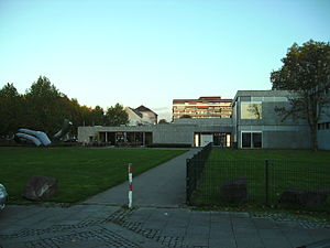
Saarland Museum
Distance: Approx. 2532 meters
Latitude and longitude: 49.23083333,7
The Saarland Museum is an art museum in Saarbrücken, Saarland, Germany. It is spread across three sites, each with a different specialism.
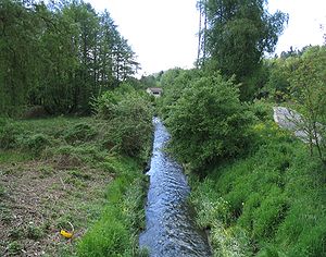
Rohrbach (Saar)
River in Germany
Distance: Approx. 1417 meters
Latitude and longitude: 49.21138889,7.02472222
Rohrbach is a river of Saarland, Germany. It flows into the Saar near Saarbrücken.
Eschberg
Distance: Approx. 1250 meters
Latitude and longitude: 49.233806,7.037385
Eschberg is a part of Saarbrücken, the capital of Saarland and has a population of 7,000 residents.

Saarbrücken Ost station
Railway station in Saarbrücken, Germany
Distance: Approx. 1306 meters
Latitude and longitude: 49.23027778,7.01861111
Saarbrücken Ost station is a station in Saarbrücken, the capital of the German state of Saarland, which is served by Regional-Express and Regionalbahn services.
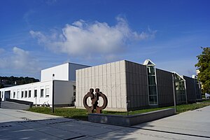
Hochschule für Musik Saar
Distance: Approx. 2664 meters
Latitude and longitude: 49.2303,6.9978
The Hochschule für Musik Saar is a conservatory of music in Saarbrücken, Germany and dates back to 1947. From 1994 until 2002, it was named Hochschule des Saarlandes für Musik und Theater (University of Music and Drama Saarbrücken). Since 2012, the rector is Prof.

Deutsch-Französisches Gymnasium Saarbrücken
French-german school (dfg/lfa) school in Germany
Distance: Approx. 1424 meters
Latitude and longitude: 49.2301,7.0164
DFG LFA Saarbrücken (French: Lycée Franco-Allemand de Sarrebruck, German: Deutsch-Französisches Gymnasium Saarbrücken is a French-German international gymnasium/collège and lycée (grades 5 to 12) in Saarbrücken, Germany. It is jointly administered by the French education agency AEFE and the local Regionalverband Saarbrücken district. The school is one of the DFG / LFA established in the 1963 Élysée Treaty between France and West Germany; the school was established in 1961 (1961) as a cooperation between a French and a German school and later became one school.

Saarbrücken Zoo
Zoo in Graf-Stauffenberg-Straße Saarbrücken, Germany
Distance: Approx. 998 meters
Latitude and longitude: 49.23076111,7.03958056
The Saarbrücken Zoo (German: Zoologischer Garten der Landeshauptstadt Saarbrücken) is with over 200.000 visitors annually, and over 1.700 animals from 160 Species the largest Zoo in Saarland. The Zoo is specialized in African animals.
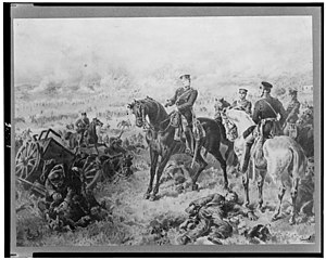
Battle of Saarbrücken
A Short skirmish that took place during the Franco-Prussian War
Distance: Approx. 2641 meters
Latitude and longitude: 49.23333333,7
The Battle of Saarbrücken was the first major engagement between the French Empire and the Kingdom of Prussia during the Franco-Prussian War. The battle took place on 2 August 1870, around the city of Saarbrücken.

Halberg Castle
German castle
Distance: Approx. 139 meters
Latitude and longitude: 49.2229,7.0308
Halberg Castle (German: Schloss Halberg) is a German castle built between 1877 and 1880 on Halberg mountain near Saarbrücken. The castle is located in the area of the former municipality of Brebach, which was merged with Fechingen to form Brebach-Fechingen in 1959 and incorporated into Saarbrücken in 1974. The castle complex, which was designed by the architects Edwin Oppler and Ferdinand Schorbach for Carl Ferdinand von Stumm-Halberg, is the second largest neo-Gothic secular building in Saarland after the St.
Weather in this IP's area
clear sky
14 Celsius
13 Celsius
11 Celsius
14 Celsius
1018 hPa
82 %
1018 hPa
989 hPa
10000 meters
5.14 m/s
50 degree
07:15:50
19:34:40