185.249.77.4 - IP Lookup: Free IP Address Lookup, Postal Code Lookup, IP Location Lookup, IP ASN, Public IP
Country:
 Spain
SpainRegion:
City:
Location:
Time Zone:
Postal Code:
ISP:
ASN:
language:
User-Agent:
Proxy IP:
Blacklist:
IP information under different IP Channel
ip-api
Country
Region
City
ASN
Time Zone
ISP
Blacklist
Proxy
Latitude
Longitude
Postal
Route
db-ip
Country
Region
City
ASN
Time Zone
ISP
Blacklist
Proxy
Latitude
Longitude
Postal
Route
IPinfo
Country
Region
City
ASN
Time Zone
ISP
Blacklist
Proxy
Latitude
Longitude
Postal
Route
IP2Location
185.249.77.4Country
esRegion
valenciana, comunidad
City
rosell
Time Zone
Europe/Madrid
ISP
Language
User-Agent
Latitude
Longitude
Postal
ipdata
Country
Region
City
ASN
Time Zone
ISP
Blacklist
Proxy
Latitude
Longitude
Postal
Route
Popular places and events near this IP address
Tinença de Benifassà
Distance: Approx. 7033 meters
Latitude and longitude: 40.65666667,0.15555556
Tinença de Benifassà (Valencian: [tiˈnɛnsa ðe benifaˈsa]) is a historical comarca of the Valencian Community, Spain. It is nowadays part of the Baix Maestrat, one of the present-day Comarques of the Valencian Community, even though commercial and human relationships have been stronger with Els Ports in the west, the Terres de l'Ebre in the northeast and the Matarranya in the northwest in historical times.
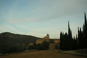
La Pobla de Benifassà
Municipality in Valencian Community, Spain
Distance: Approx. 7033 meters
Latitude and longitude: 40.65666667,0.15555556
La Pobla de Benifassà (Valencian pronunciation: [la ˈpɔbla ðe benifaˈsa]) is a municipality in the comarca of Baix Maestrat in the Valencian Community, Spain. It is located in the historical comarca of Tinença de Benifassà. Most villages in the area have only residual population owing to massive emigration in the late 20th century.

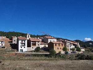
Rossell, Castellón
Municipality in Valencian Community, Spain
Distance: Approx. 233 meters
Latitude and longitude: 40.61861111,0.22388889
Rossell (Valencian pronunciation: [roˈseʎ]) is a municipality in the comarca of Baix Maestrat in the Valencian Community, Spain. The town is located at the eastern end of the Ports de Tortosa-Beseit, in the area known as Muntanyes de Benifassà. Rossell is part of the Taula del Sénia free association of municipalities.

Taula del Sénia
Free association of municipalities in Spain
Distance: Approx. 8928 meters
Latitude and longitude: 40.61194444,0.32666667
The Taula del Sénia (Catalan pronunciation: [ˈtawlə ðəl ˈseniə]) or Mancomunitat de la Taula del Sénia is a commonwealth or free association of municipalities made up of 22 towns, totalling up to 100,000 people, of some of the comarcas that make up the center of the historical region of Ilercavonia (present day southern Aragon and Catalonia, and northern Valencia), Spain. The origin of the name lies in the fact that all municipal terms involved are located within 15 km of the Sénia River, perceived as the centre of the region in its upper course.

Canet lo Roig
Municipality in Valencian Community, Spain
Distance: Approx. 7678 meters
Latitude and longitude: 40.55083333,0.2425
Canet lo Roig (Valencian pronunciation: [kaˈned lo ˈrɔtʃ]) is a municipality in the comarca of Baix Maestrat in the Valencian Community, Spain. The Serra de Sant Pere rises southeast of the town and the Cérvol River flows north of it. The Moles de Xert rise west of Canet, on the right side of the road between this town and Xert.

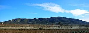
Penyagalera
Mountain in Spain
Distance: Approx. 3868 meters
Latitude and longitude: 40.64861111,0.24272222
Penyagalera (Catalan pronunciation: [ˌpɛɲəɣəˈlɛɾə]) is a rocky mountain in the northern side of the Ports de Tortosa-Beseit, Aragon, Spain. Punta de Penyagalera, the highest summit, has an altitude of 1,034.4 metres above sea level. Penyagalera, the name of the mountain (penya "rock" and galera "galley" in Catalan) derives from the fact that it looks like a ship keel upwards from certain angles.
Serra de Sant Pere
Distance: Approx. 9562 meters
Latitude and longitude: 40.54027778,0.26972222
Serra de Sant Pere (Saint Peter's Range) (Valencian pronunciation: [ˈsɛra ðe ˈsam ˈpeɾe], Spanish: Sierra del Solá) or Serra del Solà is a 5.8 km (4 mi) long mountain range in the Baix Maestrat comarca, Valencian Community, Spain. Its highest point is Tossal de Sant Pere (541 m).

Serra del Turmell
Distance: Approx. 7578 meters
Latitude and longitude: 40.57527778,0.15138889
Serra del Turmell, also known as Serra del Mont Turmell, (Spanish: Sierra del Turmell) is an over 12 km (7 mi) long mountain range in the Baix Maestrat comarca, Valencian Community, Spain. These mountains and their neighboring ranges are a desolate place with little human habitation. Their summits are frequently covered in snow in the winter.

Ulldecona Dam
Dam in Valencian Community, Spain
Distance: Approx. 5950 meters
Latitude and longitude: 40.67083333,0.23111111
The Ulldecona Dam (Catalan: Embassament d'Ulldecona) (Spanish: Embalse de Ulldecona) is a gravity dam located in the Tinença de Benifassà and the Ports de Tortosa-Beseit mountains, within the La Pobla de Benifassà municipal limits, Valencian Community, Spain. The dam was built in 1967 and was financed by farmers from the town of Ulldecona, hence its name.
Weather in this IP's area
light rain
11 Celsius
10 Celsius
10 Celsius
11 Celsius
1017 hPa
77 %
1017 hPa
943 hPa
10000 meters
12.56 m/s
19.17 m/s
324 degree
88 %