Country:
 Netherlands
Region:
City:
Latitude and Longitude:
Time Zone:
Postal Code:
IP information under different IP Channel
ip-api
Country
Region
City
ASN
Time Zone
ISP
Blacklist
Proxy
Latitude
Longitude
Postal
Route
IPinfo
Country
Region
City
ASN
Time Zone
ISP
Blacklist
Proxy
Latitude
Longitude
Postal
Route
MaxMind
Country
Region
City
ASN
Time Zone
ISP
Blacklist
Proxy
Latitude
Longitude
Postal
Route
Luminati
Country
NLRegion
fr
City
leeuwarden
ASN
Time Zone
Europe/Amsterdam
ISP
Qupra B.V.
Latitude
Longitude
Postal
db-ip
Country
Region
City
ASN
Time Zone
ISP
Blacklist
Proxy
Latitude
Longitude
Postal
Route
ipdata
Country
Region
City
ASN
Time Zone
ISP
Blacklist
Proxy
Latitude
Longitude
Postal
Route
Popular places and events near this IP address

Friesland
Province of the Netherlands
Distance: Approx. 1556 meters
Latitude and longitude: 53.20138889,5.8
Friesland (, Dutch: [ˈfrislɑnt] ; official West Frisian: Fryslân [ˈfrislɔ̃ːn] ), historically and traditionally known as Frisia, named after the Frisians, is a province of the Netherlands located in the country's northern part. It is situated west of Groningen, northwest of Drenthe and Overijssel, north of Flevoland, northeast of North Holland, and south of the Wadden Sea. As of January 2023, the province had a population of about 660,000, and a total area of 5,753 km2 (2,221 sq mi).

Leeuwarden
City and municipality in Friesland, Netherlands
Distance: Approx. 1339 meters
Latitude and longitude: 53.2,5.78333333
Leeuwarden (Dutch: [ˈleːu.ɑrdə(n)] ; West Frisian: Ljouwert [ˈljɔːʋ(ə)t]/[ˈʎɔːw(ə)t] ; Town Frisian: Liwwadden; Leeuwarder dialect: Leewarden) is a city and municipality in Friesland, Netherlands, with a population of 127,073 (2023). It is the provincial capital and seat of the Provincial Council of Friesland. The region has been continuously inhabited since the 10th century.

Oldehove (tower)
Leaning tower in Leeuwarden, Netherlands
Distance: Approx. 1590 meters
Latitude and longitude: 53.20297778,5.78971111
The Oldehove (West Frisian: Aldehou [ˈɔːdəhɔu]) is a leaning and unfinished church tower in the medieval centre of the Dutch city of Leeuwarden. Oldehove is also the name of an artificial mound (terp) on which in the late 9th century a (Catholic) church dedicated to Saint Vitus was built. Construction of the adjoining Late Gothic tower began in 1529, after the citizens of Leeuwarden demanded a tower taller than the one in the city of Groningen, the Martinitoren.

Leeuwarder Courant
Dutch newspaper
Distance: Approx. 1159 meters
Latitude and longitude: 53.19666667,5.80138889
The Leeuwarder Courant is the oldest daily newspaper in the Netherlands. Founded by Abraham Ferwerda, it first appeared in 1752. The Leeuwarder Courant was the first paper in the Dutch province Friesland and its capital Leeuwarden.

Goutum
Village in Friesland, Netherlands
Distance: Approx. 1558 meters
Latitude and longitude: 53.17861111,5.80638889
Goutum is a village in the municipality Leeuwarden in the province of Friesland, the Netherlands. It had a population of around 2,945 in January 2017. It is still an independent village, but is surrounded by the city of Leeuwarden on all sides.

Leeuwarden railway station
Railway station in Leeuwarden, Netherlands
Distance: Approx. 796 meters
Latitude and longitude: 53.19583333,5.79111111
Leeuwarden railway station is the main railway station in Leeuwarden in Friesland, Netherlands. The station, which opened on 27 October 1863, is on the Arnhem–Leeuwarden railway, the Harlingen–Nieuweschans railway and the Leeuwarden–Stavoren railway. Leeuwarden was also the terminus of the North Friesland Railway which served Anjum and Harlingen via Stiens.

Molen Hoogland, Goutum
Distance: Approx. 1601 meters
Latitude and longitude: 53.1756,5.7803
Molen Hoogland is a Hollow Post mill in Goutum, Friesland, Netherlands which was built in 2004. The mill is listed as a Rijksmonument, number 24521.
Protestant church of Goutum
Church
Distance: Approx. 1586 meters
Latitude and longitude: 53.1785,5.8068
The Protestant church of Goutum or Saint Agnes church is a medieval religious building in Goutum, Friesland, Netherlands. On the northern side remnants of an older tufa church from the 11th century or 12th century can be seen. The church was enlarged and heightened with brick in the 15th century and has a tower from the same century.

Stadhouderlijk Hof
Former residence of the Dutch royal family
Distance: Approx. 1576 meters
Latitude and longitude: 53.2025,5.7955
Stadhouderlijk Hof in the city of Leeuwarden is a former residence of the Dutch royal family and was owned by them until 1971.
Tresoar
Museum, archive in Leeuwarden, Netherlands
Distance: Approx. 1648 meters
Latitude and longitude: 53.2035,5.790278
Tresoar (West Frisian for "treasure") is the short name for the Frysk Histoarysk en Letterkundich Sintrum ("Frisian History and Literature Center") in Leeuwarden. Tresoar manages digital archives about Friesland and its literature. There is a study room open to the public, and most catalogs are online and free to access.
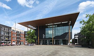
Fries Museum
Museum in Leeuwarden, Netherlands
Distance: Approx. 1246 meters
Latitude and longitude: 53.1996,5.79444
The Fries Museum (Frisian Museum) is a museum in Leeuwarden, Netherlands. It has won the Global Fine Art Award which is sometimes nicknamed the Museum-Oscar.

Huizum
Residential area in Friesland, Netherlands
Distance: Approx. 1445 meters
Latitude and longitude: 53.19138889,5.81138889
Huizum is a residential area of the municipality of Leeuwarden in the province of Friesland, Netherlands. It has approximately 9,000 inhabitants. Huizum was formerly part of Leeuwarderadeel and incorporates a former village.
Weather in this IP's area
mist
14 Celsius
14 Celsius
14 Celsius
16 Celsius
1028 hPa
86 %
1028 hPa
1028 hPa
1000 meters
3.6 m/s
60 degree
100 %
07:17:59
19:43:12