Country:
 Germany
Region:
City:
Latitude and Longitude:
Time Zone:
Postal Code:
IP information under different IP Channel
ip-api
Country
Region
City
ASN
Time Zone
ISP
Blacklist
Proxy
Latitude
Longitude
Postal
Route
IPinfo
Country
Region
City
ASN
Time Zone
ISP
Blacklist
Proxy
Latitude
Longitude
Postal
Route
MaxMind
Country
Region
City
ASN
Time Zone
ISP
Blacklist
Proxy
Latitude
Longitude
Postal
Route
Luminati
Country
DERegion
nw
City
dortmund
ASN
Time Zone
Europe/Berlin
ISP
GLASFASER RUHR GmbH & Co. KG
Latitude
Longitude
Postal
db-ip
Country
Region
City
ASN
Time Zone
ISP
Blacklist
Proxy
Latitude
Longitude
Postal
Route
ipdata
Country
Region
City
ASN
Time Zone
ISP
Blacklist
Proxy
Latitude
Longitude
Postal
Route
Popular places and events near this IP address

Hengsteysee
Dam in North Rhine-Westphalia
Distance: Approx. 3006 meters
Latitude and longitude: 51.41388889,7.46194444
The Hengsteysee (Lake Hengstey) is a reservoir on the Ruhr river between the cities of Hagen, Dortmund and Herdecke, North Rhine-Westphalia, Germany. It was built in 1929 and is one of five reservoirs on the Ruhr. The reservoir is about 4.2 km (2.6 mi) long and has an average width of 296 meters (971 ft).

Syberg
Mountain in Germany
Distance: Approx. 2978 meters
Latitude and longitude: 51.42028,7.48583
The Syberg is a hill in the Ruhr in the southern part of Dortmund, 240 m above sea level (NN), which is part of the Ardey Hills. The Syberg is home to the Sigiburg, the Vincke Tower, a monument to Emperor William I and other points of interest. The family name of the House of Syberg is derived from the Syberg.

Wichlinghofen
Human settlement in Germany
Distance: Approx. 2515 meters
Latitude and longitude: 51.45111111,7.49055556
Wichlinghofen is a Stadtteil (Quarter) in the south of the city of Dortmund, in Germany. With its 3,500 inhabitants it is like a separate village in the city. The city is building a rain retention basin in Wichlinghofen.
Klusenberg
Mountain in Germany
Distance: Approx. 2244 meters
Latitude and longitude: 51.42222,7.47083
The Klusenberg is, at 254.33 m above NHN, the highest elevation on the territory of the city of Dortmund. The Klusenberg part of the Ardey Hills lies west of the Hohensyburg. To the south its slopes fall away into the Hengsteysee lake.

Dortmund-Kruckel station
Railway station in Dortmund, Germany
Distance: Approx. 3551 meters
Latitude and longitude: 51.45845623,7.41566515
Dortmund-Kruckel station lies on the border between the suburbs of Dortmund-Kruckel and Dortmund-Persebeck of the city of Dortmund in the German state of North Rhine-Westphalia on the Elberfeld–Dortmund line. The station is currently classified as a category 6 station. It is served by regional services and Rhine-Ruhr S-Bahn line S 5.

St. Peter, Syburg
Church in Northrhine-Westphalia, Germany
Distance: Approx. 2998 meters
Latitude and longitude: 51.4225,7.49
St. Peter (also St. Peter zu Syburg) is a Romanesque church in Syburg, now a suburb of Dortmund, Germany.

Dortmund-Löttringhausen station
Railway station in Dortmund, Germany
Distance: Approx. 1433 meters
Latitude and longitude: 51.45166667,7.44722222
Dortmund-Löttringhausen station is on the former Rhenish Railway Company in the suburb of Löttringhausen in the Dortmund district of Hombruch in the German state of North Rhine-Westphalia.
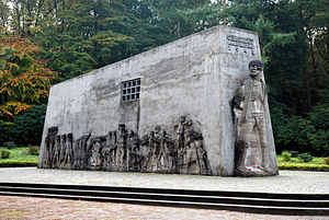
Mahnmal Bittermark
Memorial in Dortmund
Distance: Approx. 1644 meters
Latitude and longitude: 51.4481,7.4789
The Mahnmal Bittermark is a memorial place in Bittermark, a borough in the city of Dortmund, Germany. The place commemorates about 300 people killed by the Gestapo in Bittermark city forest and in the Rombergpark between March 7 and April 12, 1945. The people killed were forced laborers from France, Belgium, the Netherlands, Yugoslavia, Poland and the Soviet Union, members of the German resistance, as well as ordinary people whose careless utterance was judged to be "the dissemination of the opinion about the futility of the war and the insult of Hitler".

Sigiburg
Distance: Approx. 3052 meters
Latitude and longitude: 51.42,7.48694444
The Sigiburg was a Saxon hillfort in Western Germany, overlooking the River Ruhr near its confluence with the River Lenne. The ruins of the later Hohensyburg castle now stand on the site, which is in Syburg, a neighbourhood in the Hörde district of Dortmund. Archaeological evidence suggests the site was occupied in the Neolithic era.

Dortmund-Kirchhörde station
Railway station in Dortmund, Germany
Distance: Approx. 2605 meters
Latitude and longitude: 51.4642,7.4578
Dortmund-Kirchhörde station is a railway station in the Kirchhörde district of the town of Dortmund, located in North Rhine-Westphalia, Germany.
Syburg
Borough of Dortmund in North Rhine-Westphalia, Germany
Distance: Approx. 2628 meters
Latitude and longitude: 51.42555556,7.48722222
Syburg is a borough (Stadtbezirk) of the city of Dortmund in the Ruhr district of North Rhine-Westphalia, Germany. Since 1929, it has been a borough of Dortmund, located in the city's south. It is part of the Hörde district.

St. Patrokli, Kirchhörde
Distance: Approx. 1786 meters
Latitude and longitude: 51.456845,7.458244
St. Patrokli is a Catholic church ad parish Kirchhörde, a Stadtteil of Dortmund, North Rhine-Westphalia. The parish also has churches in St.
Weather in this IP's area
few clouds
16 Celsius
16 Celsius
15 Celsius
17 Celsius
1013 hPa
91 %
1013 hPa
991 hPa
10000 meters
0.51 m/s
20 %
07:59:26
18:30:45