Country:
 Norway
Region:
City:
Latitude and Longitude:
Time Zone:
Postal Code:
IP information under different IP Channel
ip-api
Country
Region
City
ASN
Time Zone
ISP
Blacklist
Proxy
Latitude
Longitude
Postal
Route
IPinfo
Country
Region
City
ASN
Time Zone
ISP
Blacklist
Proxy
Latitude
Longitude
Postal
Route
MaxMind
Country
Region
City
ASN
Time Zone
ISP
Blacklist
Proxy
Latitude
Longitude
Postal
Route
Luminati
Country
NORegion
15
City
isfjorden
ASN
Time Zone
Europe/Oslo
ISP
Telenor Norge AS
Latitude
Longitude
Postal
db-ip
Country
Region
City
ASN
Time Zone
ISP
Blacklist
Proxy
Latitude
Longitude
Postal
Route
ipdata
Country
Region
City
ASN
Time Zone
ISP
Blacklist
Proxy
Latitude
Longitude
Postal
Route
Popular places and events near this IP address
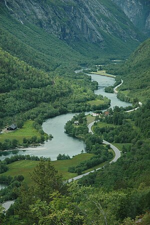
Rauma (river)
River in Norway
Distance: Approx. 6349 meters
Latitude and longitude: 62.5575,7.67806
The Rauma is a river that runs through Romsdalen, a valley in Møre og Romsdal and Innlandet counties in Norway. It runs for 68 kilometres (42 mi) from Lesjaskogsvatnet, a lake in the municipality of Lesja, to the town of Åndalsnes in the municipality of Rauma. The river was once famous for its salmon-fishing, but since an infection with Gyrodactylus salaris only 5 to 10% of the original stock survives.
Åndalsnes
Town in Western Norway, Norway
Distance: Approx. 5652 meters
Latitude and longitude: 62.5675,7.6871
is a town in Rauma Municipality in Møre og Romsdal county, Norway. Åndalsnes is in the administrative center of Rauma Municipality. It is located along the Isfjorden, at the mouth of the river Rauma, at the north end of the Romsdalen valley.

Isfjorden (village)
Village in Western Norway, Norway
Distance: Approx. 430 meters
Latitude and longitude: 62.5778,7.7923
Isfjorden is a village in Rauma Municipality in Møre og Romsdal county, Norway. It is located about 6 kilometres (3.7 mi) east of the town of Åndalsnes. The mountains Kyrkjetaket and Gjuratinden lie a few kilometers away.

Åndalsnes landings
Distance: Approx. 5926 meters
Latitude and longitude: 62.56345833,7.68321944
The Åndalsnes landings were a British military operation in 1940, during the Norwegian Campaign of World War II. Following the German invasion of Norway in April 1940, a British Army expeditionary force was landed at Åndalsnes, in Romsdal, to support Norwegian Army units defending the city of Trondheim. British forces were also landed at Namsos, north of Åndalsnes, in a complementary pincer movement. The British landings were unsuccessful and the Allies suffered a significant defeat at Åndalsnes.
Hen, Møre og Romsdal
Former municipality in Norway
Distance: Approx. 2910 meters
Latitude and longitude: 62.55,7.81666667
Hen is a former municipality in Møre og Romsdal county, Norway. The 245-square-kilometre (95 sq mi) municipality existed from 1902 until its dissolution in 1964. Hen encompassed the valleys extending to the south and east of the Isfjorden in the northeastern part of the present-day Rauma Municipality.
Hen Church
Church in Møre og Romsdal, Norway
Distance: Approx. 424 meters
Latitude and longitude: 62.57745061,7.79134244
Hen Church (Norwegian: Hen kyrkje) is a parish church of the Church of Norway in Rauma Municipality in Møre og Romsdal county, Norway. It is located in the village of Isfjorden, about 6 kilometres (3.7 mi) east of the town of Åndalsnes. It is the church for the Hen parish which is part of the Indre Romsdal prosti (deanery) in the Diocese of Møre.

Kyrkjetaket
Distance: Approx. 6850 meters
Latitude and longitude: 62.61194444,7.90222222
Kyrkjetaket or Kirketaket is a mountain on the border of the municipalities of Rauma and Nesset in Møre og Romsdal county, Norway. The 1,439-metre (4,721 ft) tall peak is located in Rauma, about 7 kilometres (4.3 mi) northeast of the village of Isfjorden and 12.4 kilometres (7.7 mi) from the town of Åndalsnes. The mountain Gjuratinden lies about 9 kilometres (5.6 mi) southeast of Kyrkjetaket.

Åndalsnes Station
Railway station in Rauma, Norway
Distance: Approx. 5495 meters
Latitude and longitude: 62.56722222,7.69027778
Åndalsnes Station (Norwegian: Åndalsnes stasjon) is a railway station in the town of Åndalsnes, the administrative centre of Rauma Municipality in Møre og Romsdal county, Norway. It has served as the terminal station of the Rauma Line since the line was extended to Åndalsnes on November 30, 1924. The station was designed by Gudmund Hoel and is located on reclaimed land along Isfjorden.

Veblungsnes
Village in Western Norway, Norway
Distance: Approx. 7185 meters
Latitude and longitude: 62.5532,7.664
Veblungsnes is a village located in Rauma Municipality in Møre og Romsdal county, Norway. The village lies along Romsdal Fjord just across the mouth of the Rauma river from the town of Åndalsnes. The European route E136 highway runs through the village on its way from Åndalsnes southwest to the village of Innfjorden.

Sogge Bridge
Bridge in Rauma, Norway
Distance: Approx. 5560 meters
Latitude and longitude: 62.532645,7.736844
The Sogge Bridge (Norwegian: Sogge bru) is a truss bridge crossing the river Rauma in Rauma Municipality in Møre og Romsdal county, Norway. The bridge carries County Road 63. The intersection between E136 and County Road 63 is located on the north side of the bridge.

Istra (Rauma)
River in Norway
Distance: Approx. 6711 meters
Latitude and longitude: 62.5379,7.6922
The Istra is a river in Rauma Municipality in Møre og Romsdal county, Norway. The river runs through the Isterdalen valley before emptying into the Rauma river in the Romsdalen valley. It discharges into the Rauma about 3 kilometres (1.9 mi) south of the town of Åndalsnes.

Grytten Church
Church in Møre og Romsdal, Norway
Distance: Approx. 6772 meters
Latitude and longitude: 62.55273827,7.67292291
Grytten Church (Norwegian: Grytten kyrkje) is a parish church of the Church of Norway in Rauma Municipality in Møre og Romsdal county, Norway. It is located near the mouth of the Rauma River in the village of Veblungsnes. It is the church for the Grytten parish which is part of the Indre Romsdal prosti (deanery) in the Diocese of Møre.
Weather in this IP's area
clear sky
7 Celsius
4 Celsius
7 Celsius
7 Celsius
1011 hPa
81 %
1011 hPa
1010 hPa
10000 meters
4.77 m/s
5.54 m/s
148 degree
1 %
08:26:19
18:00:48