185.246.11.59 - IP Lookup: Free IP Address Lookup, Postal Code Lookup, IP Location Lookup, IP ASN, Public IP
Country:
 Italy
ItalyRegion:
City:
Location:
Time Zone:
Postal Code:
ISP:
ASN:
language:
User-Agent:
Proxy IP:
Blacklist:
IP information under different IP Channel
ip-api
Country
Region
City
ASN
Time Zone
ISP
Blacklist
Proxy
Latitude
Longitude
Postal
Route
db-ip
Country
Region
City
ASN
Time Zone
ISP
Blacklist
Proxy
Latitude
Longitude
Postal
Route
IPinfo
Country
Region
City
ASN
Time Zone
ISP
Blacklist
Proxy
Latitude
Longitude
Postal
Route
IP2Location
185.246.11.59Country
itRegion
puglia
City
torremaggiore
Time Zone
Europe/Rome
ISP
Language
User-Agent
Latitude
Longitude
Postal
ipdata
Country
Region
City
ASN
Time Zone
ISP
Blacklist
Proxy
Latitude
Longitude
Postal
Route
Popular places and events near this IP address
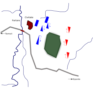
Battle of Civitate
1053 battle between the Normans and a coalition of Swabian, Italian, and Lombard forces
Distance: Approx. 5347 meters
Latitude and longitude: 41.73333333,15.26666667
The Battle of Civitate was fought on 18 June 1053 in southern Italy, between the Normans, led by the Count of Apulia Humphrey of Hauteville, and a Swabian-Italian-Lombard army, organised by Pope Leo IX and led on the battlefield by Gerard, Duke of Lorraine, and Rudolf, Prince of Benevento. The Norman victory over the allied papal army marked the climax of a conflict between the Norman mercenaries who came to southern Italy in the eleventh century, the de Hauteville family, and the local Lombard princes. By 1059 the Normans would create an alliance with the papacy, which included a formal recognition by Pope Nicholas II of the Norman conquest in south Italy, investing Robert Guiscard as Duke of Apulia and Calabria, and Count of Sicily.

San Paolo di Civitate
Comune in Apulia, Italy
Distance: Approx. 5347 meters
Latitude and longitude: 41.73333333,15.26666667
San Paolo di Civitate is a town and comune in the province of Foggia in the Apulia region of south-east Italy. San Paolo di Civitate was historically an Arbëreshë settlement; the inhabitants, however, no longer use the Albanian language.

Roman Catholic Diocese of San Severo
Roman Catholic diocese in Italy
Distance: Approx. 6917 meters
Latitude and longitude: 41.6951,15.3793
The Diocese of San Severo (Latin: Dioecesis Sancti Severi) is a Latin diocese of the Catholic Church in Apulia. It is a suffragan of the Archdiocese of Foggia-Bovino.

Sterparone Airfield
Distance: Approx. 9940 meters
Latitude and longitude: 41.60174444,15.30666667
Sterparone Airfield is an abandoned World War II military airfield in Italy. It was located 11.1 kilometers south-southeast of San Severo, in the Province of Foggia. The airfield was abandoned and dismantled after the end of the war in 1945.

San Severo railway station
Railway station in Italy
Distance: Approx. 8001 meters
Latitude and longitude: 41.6846,15.3922
San Severo railway station is an Italian railway station situated in San Severo. It is one of the main railway stations in the province of Foggia.
1627 Gargano earthquake
Large earthquake in eastern Italy
Distance: Approx. 6581 meters
Latitude and longitude: 41.74,15.34
The 1627 Gargano earthquake struck Gargano and part of Tavoliere, southern Italy, at about mid-day on 30 July 1627. A "very large earthquake" caused a major tsunami, the largest seismic event ever recorded in the Gargano region, which "produced severe damage in the whole promontory", killing about 5,000 people. Four aftershocks were documented.
Weather in this IP's area
overcast clouds
10 Celsius
8 Celsius
10 Celsius
10 Celsius
1026 hPa
86 %
1026 hPa
1013 hPa
10000 meters
3.57 m/s
9.24 m/s
127 degree
99 %