185.245.17.170 - IP Lookup: Free IP Address Lookup, Postal Code Lookup, IP Location Lookup, IP ASN, Public IP
Country:
Region:
City:
Location:
Time Zone:
Postal Code:
IP information under different IP Channel
ip-api
Country
Region
City
ASN
Time Zone
ISP
Blacklist
Proxy
Latitude
Longitude
Postal
Route
Luminati
Country
ASN
Time Zone
Europe/Copenhagen
ISP
Uni-tel A/S
Latitude
Longitude
Postal
IPinfo
Country
Region
City
ASN
Time Zone
ISP
Blacklist
Proxy
Latitude
Longitude
Postal
Route
IP2Location
185.245.17.170Country
Region
hovedstaden
City
lillerod
Time Zone
Europe/Copenhagen
ISP
Language
User-Agent
Latitude
Longitude
Postal
db-ip
Country
Region
City
ASN
Time Zone
ISP
Blacklist
Proxy
Latitude
Longitude
Postal
Route
ipdata
Country
Region
City
ASN
Time Zone
ISP
Blacklist
Proxy
Latitude
Longitude
Postal
Route
Popular places and events near this IP address

Allerød Municipality
Municipality in Hovedstaden, Denmark
Distance: Approx. 1600 meters
Latitude and longitude: 55.86666667,12.36666667
Allerød Kommune is a municipality (Danish, kommune) on the island of Zealand (Sjælland) in eastern Denmark. The municipality covers an area of 67 km2, and has a population of 25,962 (1 January 2024). Its mayor is Karsten Längerich of the political party Venstre.

Nordbanen
Railway line in North Zealand, Denmark
Distance: Approx. 2646 meters
Latitude and longitude: 55.8585,12.3763
Nordbanen is one of six radial S-train lines in Copenhagen.

Allerød railway station
Railway station in North Zealand, Denmark
Distance: Approx. 829 meters
Latitude and longitude: 55.871,12.357
Allerød station is an S-train railway station serving the satellite town of Lillerød in Allerød municipality north of Copenhagen, Denmark. Allerød station is located on the Hillerød radial of Copenhagen's S-train network. The station opened in 1864.
Høvelte railway halt
Railway halt in North Zealand, Denmark
Distance: Approx. 3769 meters
Latitude and longitude: 55.85083333,12.38805556
Høvelte railway halt (Danish: Høvelte Trinbræt) is a railway halt on the Hillerød radial of the S-train network in Greater Copenhagen, Denmark. It is located between Birkerød station and Allerød station and primarily serves Høvelte Barracks. There is only one station platform by the northbound track.

Lillerød
Place in Capital, Denmark
Distance: Approx. 815 meters
Latitude and longitude: 55.86805556,12.34166667
Lillerød (sometimes named Allerød) is a Danish town, seat of the Allerød Municipality, in the Region Hovedstaden. Its population 1 January 2024 was of 16,801.
Center Sandholm
Danish public institution for asylum seekers
Distance: Approx. 3396 meters
Latitude and longitude: 55.8725,12.4
Center Sandholm, or Sandholm, is a public institution for asylum seekers in Denmark. It is located in Sandholm, Blovstrød, Allerød Kommune. Children and young people under 18 who have fled alone are received at Center Gribskov.
Store Dyrehave
Distance: Approx. 4278 meters
Latitude and longitude: 55.91277778,12.35833333
Store Dyrehave (literally Large Animal Park) is a forest located to the east of the village Ny Hammersholt immediately south of Hillerød, on both sides of Københavnsvej, in North Zealand, Denmark. Consisting of conifers and beech, it was enclosed with stone walls in 1619–28 as a royal deer park for hunting. In 1680, Christian V introduced a geometrical system of roads forming a star with eight branches for par force hunting.
Tokkekøb Hegn
Distance: Approx. 2521 meters
Latitude and longitude: 55.88333333,12.38333333
Tokkekøb Hegn is a forest located north of Blovstrød and east of Lillerød in Allerød Municipality, North Zealand, some 20 km north of central Copenhagen, Denmark. It adjoins Store Dyrehave to the north, although an open landscape surrounding the village of Kirkelte partly separates the two forests. To the south it adjoins the Høvelte-Sandholm military trainings grounds.
Sandholm
Danish estate
Distance: Approx. 3667 meters
Latitude and longitude: 55.87,12.40383333
Sandholm is an estate in the parish of Blovstrød, Allerød Municipality some 30 km north of Copenhagen, Denmark.

Blovstrød
Town in Capital Region, Denmark
Distance: Approx. 2516 meters
Latitude and longitude: 55.86916667,12.38472222
Blovstrød is a small town and parish in Allerød Municipality, North Zealand, located some 30 km north of Copenhagen, Denmark. The town is situated on the east side of Lyngby Kongevej, approximately one kilometre east of Lillerød and Allerød station. Two new neighbourhoods, Ny Blovstrød and Teglværkskvarteret, are planned on the west side of Lyngby Kongevej.

Brudevælte Lurs
Distance: Approx. 4222 meters
Latitude and longitude: 55.855556,12.287778
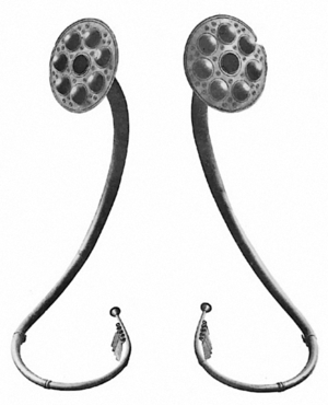
The Brudevælte Lurs, found in a bog north of Lynge on the Danish island of Zealand, are six lurs, which are so well preserved that they can still be played.

Lillerød Church
Distance: Approx. 169 meters
Latitude and longitude: 55.87348,12.34595
Lillerød Church (Danish: Lillerød Kirke) is a parish church in Lillerød, Allerød Municipality, some 20 km north of central Copenhagen, Denmark.
Weather in this IP's area
overcast clouds
8 Celsius
3 Celsius
7 Celsius
8 Celsius
1015 hPa
91 %
1015 hPa
1009 hPa
10000 meters
9.24 m/s
16.46 m/s
246 degree
100 %


