Country:
Region:
City:
Latitude and Longitude:
Time Zone:
Postal Code:
IP information under different IP Channel
ip-api
Country
Region
City
ASN
Time Zone
ISP
Blacklist
Proxy
Latitude
Longitude
Postal
Route
Luminati
Country
ASN
Time Zone
Europe/Zagreb
ISP
CRATIS d.o.o.
Latitude
Longitude
Postal
IPinfo
Country
Region
City
ASN
Time Zone
ISP
Blacklist
Proxy
Latitude
Longitude
Postal
Route
db-ip
Country
Region
City
ASN
Time Zone
ISP
Blacklist
Proxy
Latitude
Longitude
Postal
Route
ipdata
Country
Region
City
ASN
Time Zone
ISP
Blacklist
Proxy
Latitude
Longitude
Postal
Route
Popular places and events near this IP address

Bjelovar-Bilogora County
County in central Croatia
Distance: Approx. 1092 meters
Latitude and longitude: 45.90277778,16.8475
Bjelovar-Bilogora County (pronounced [bjêloʋaːr-bîloɡora]; Croatian: Bjelovarsko-bilogorska županija [bjêloʋaːrsko-bîloɡorskaː ʒupǎnija]) is a county in central Croatia. The central city of Bjelovar was first mentioned in 1413, and it only gained importance when a new fort was built in 1756 to defend against the Ottoman invasions. The town was pronounced a free royal town in 1874.
Bjelovar
City in Bjelovar-Bilogora County, Croatia
Distance: Approx. 573 meters
Latitude and longitude: 45.9,16.83333333
Bjelovar (Hungarian: Belovár, German: Bellowar, Czech: Bělovar or Bělovár, Kajkavian: Belovar, Latin: Bellovarium) is a city in central Croatia. It is the administrative centre of Bjelovar-Bilogora County as well as one of the youngest cities in Croatia, officially founded in the year 1756. At the 2021 census, there were 36,433 inhabitants, of whom 93.06% were Croats.

Bjelovar-Križevci County
Historic county of the Kingdom of Croatia-Slavonia
Distance: Approx. 1068 meters
Latitude and longitude: 45.9,16.85
The Bjelovar-Križevci County (Croatian: Bjelovarsko-križevačka županija; Hungarian: Belovár-Kőrös vármegye) was a historic administrative subdivision of the Kingdom of Croatia-Slavonia. Croatia-Slavonia was an autonomous kingdom within the Lands of the Crown of Saint Stephen (Transleithania), the Hungarian part of the dual Austro-Hungarian Empire. Its territory is now in northern Croatia.
Roman Catholic Diocese of Bjelovar-Križevci
Roman Catholic diocese in Croatia
Distance: Approx. 529 meters
Latitude and longitude: 45.8982,16.8435
The Roman Catholic Diocese of Bjelovar-Križevci (Croatian: Bjelovarsko-križevačka biskupija; Latin: Dioecesis Bellovariensis-Crisiensis) is a diocese in the ecclesiastical province of Zagreb in Croatia. On December 5, 2009 Pope Benedict XVI erected the Diocese of Bjelovar-Križevci with territory taken from the Archdiocese of Zagreb. On the same day the Pope erected the new Diocese of Sisak, also in Croatia and within the Ecclesiastical province of Zagreb.
Ždralovi
Village in Bjelovar-Bilogora County, Croatia
Distance: Approx. 2645 meters
Latitude and longitude: 45.88333333,16.86666667
Ždralovi is a suburb of the city of Bjelovar.

Bjelovar Synagogue
Former synagogue in Bjelovar, Croatia
Distance: Approx. 675 meters
Latitude and longitude: 45.9,16.84388889
The Bjelovar Synagogue (Croatian: Izraelitički templ) is a former Orthodox Jewish synagogue, located in Bjelovar, Croatia. Built in 1917, partially destroyed during World War II, the building has served as the House of Culture in Bjelovar, a cultural center, since the 1950s.
Siege of Bjelovar Barracks
Part of the Battle of the Barracks
Distance: Approx. 899 meters
Latitude and longitude: 45.903407,16.833721
The siege of Bjelovar Barracks, also known by the codename Operation Bilogora (Croatian: Operacija Bilogora), was the blockade and capture of the Yugoslav People's Army (JNA) barracks and other facilities in and around the city of Bjelovar, a part of the JNA 32nd (Varaždin) Corps, during the Croatian War of Independence. A general blockade of the JNA facilities in Croatia was ordered on 14 September 1991, and it continued until 29 September when the JNA garrison was captured by Croatian forces. Its capture occurred one week after the bulk of the 32nd Corps surrendered.

Bjelovar Cathedral
Distance: Approx. 510 meters
Latitude and longitude: 45.8981,16.8433
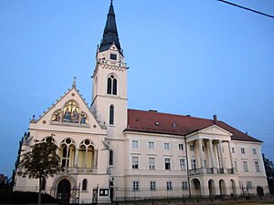
Cathedral of Teresa of Ávila in Bjelovar (Croatian: Katedrala sv. Terezije Avilske u Bjelovaru) is the baroque church of Diocese of Bjelovar-Križevci. It is located in the center of the town of Bjelovar, Croatia, on Eugen Kvaternik Square.

Makarska Co-cathedral
Distance: Approx. 510 meters
Latitude and longitude: 45.8981,16.8433
Co-cathedral of St. Mark the Evangelist (Croatian: Konkatedrala sv. Marka evanđelista) is a baroque church and former cathedral in the Archdiocese of Split-Makarska.

Greek Catholic Co-Cathedral of Saints Cyril and Methodius, Zagreb
Distance: Approx. 510 meters
Latitude and longitude: 45.8981,16.8433
The Greek Catholic Co-cathedral of Saints Cyril and Methodius (Croatian: Grkokatolička konkatedrala Sv. Ćirila i Metoda) is the historicistic co-cathedral church of the Greek Catholic Eparchy of Križevci. It belongs to the Vicariate of Diocese of Žumberak-Križevci.

Križevci Cathedral
Distance: Approx. 510 meters
Latitude and longitude: 45.8981,16.8433
Greek Catholic Cathedral of the Holy Trinity (Croatian: Grkokatolička katedrala Svetog Trojstva) is a Neo-Gothic church in Križevci, Croatia.
Roman Catholic Diocese of Makarska
Distance: Approx. 510 meters
Latitude and longitude: 45.8981,16.8433
The Diocese of Makarska was a Latin Catholic bishopric from 533 to 590, from 1344 to 1400 and from 1615 until its 1828 merger into the (meanwhile Metropolitan Arch)Diocese of Split-Makarska, which preserves its title. No statistics available.
Weather in this IP's area
overcast clouds
2 Celsius
2 Celsius
2 Celsius
2 Celsius
1026 hPa
75 %
1026 hPa
1010 hPa
10000 meters
0.59 m/s
0.67 m/s
8 degree
93 %
06:51:49
16:22:38
