Country:
 France
Region:
City:
Latitude and Longitude:
Time Zone:
Postal Code:
IP information under different IP Channel
ip-api
Country
Region
City
ASN
Time Zone
ISP
Blacklist
Proxy
Latitude
Longitude
Postal
Route
IPinfo
Country
Region
City
ASN
Time Zone
ISP
Blacklist
Proxy
Latitude
Longitude
Postal
Route
MaxMind
Country
Region
City
ASN
Time Zone
ISP
Blacklist
Proxy
Latitude
Longitude
Postal
Route
Luminati
Country
FRRegion
ara
City
chavanod
ASN
Time Zone
Europe/Paris
ISP
Alpes Networks SAS
Latitude
Longitude
Postal
db-ip
Country
Region
City
ASN
Time Zone
ISP
Blacklist
Proxy
Latitude
Longitude
Postal
Route
ipdata
Country
Region
City
ASN
Time Zone
ISP
Blacklist
Proxy
Latitude
Longitude
Postal
Route
Popular places and events near this IP address

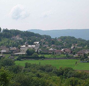
Chavanod
Commune in Auvergne-Rhône-Alpes, France
Distance: Approx. 562 meters
Latitude and longitude: 45.8908,6.0403
Chavanod (French pronunciation: [ʃavano]; Arpitan: Chavanôd) is a commune in the Haute-Savoie department and Auvergne-Rhône-Alpes region of eastern France. It is part of the urban area of Annecy.

Seynod
Part of Annecy in Auvergne-Rhône-Alpes, France
Distance: Approx. 3817 meters
Latitude and longitude: 45.8897,6.0967
Seynod (French pronunciation: [sɛno]; Arpitan: Sénu) is a former commune in the Haute-Savoie department in the Auvergne-Rhône-Alpes region in south-eastern France. On 1 January 2017, it was merged into the commune Annecy. The inhabitants of Seynod are called Seynodiens.

Cran-Gevrier
Part of Annecy in Auvergne-Rhône-Alpes, France
Distance: Approx. 5303 meters
Latitude and longitude: 45.9097,6.1107
Cran-Gevrier (French pronunciation: [kʁɑ̃ ʒəvʁije]; Arpitan: Kran-Zhèvrî) is a former commune in the Haute-Savoie department in the Auvergne-Rhône-Alpes region in south-eastern France. On 1 January 2017, it was merged into the commune Annecy.
Marcellaz-Albanais
Commune in Auvergne-Rhône-Alpes, France
Distance: Approx. 3947 meters
Latitude and longitude: 45.8756,6.0019
Marcellaz-Albanais (French pronunciation: [maʁsela albanɛ]) is a commune in the Haute-Savoie department located in the Auvergne-Rhône-Alpes region in south-eastern France.

Montagny-les-Lanches
Commune in Auvergne-Rhône-Alpes, France
Distance: Approx. 3254 meters
Latitude and longitude: 45.8622,6.0456
Montagny-les-Lanches (French pronunciation: [mɔ̃taɲi le lɑ̃ʃ]; Arpitan: Montanyi-lé-Lanshe) is a commune in the Haute-Savoie department in the Auvergne-Rhône-Alpes region in south-eastern France.
Nonglard
Commune in Auvergne-Rhône-Alpes, France
Distance: Approx. 3589 meters
Latitude and longitude: 45.9175,6.0203
Nonglard (French pronunciation: [nɔ̃ɡlaʁ]) is a commune in the Haute-Savoie department in the Auvergne-Rhône-Alpes region in south-eastern France.
Étercy
Commune in Auvergne-Rhône-Alpes, France
Distance: Approx. 2929 meters
Latitude and longitude: 45.8917,6.0097
Étercy (French pronunciation: [etɛʁsi]) is a commune in the Haute-Savoie department in the Auvergne-Rhône-Alpes region in south-eastern[France. The area of this commune is 4.55 km2 (1.76 sq mi) and population as of January 2019 is 838.

Lovagny
Commune in Auvergne-Rhône-Alpes, France
Distance: Approx. 1844 meters
Latitude and longitude: 45.905,6.0339
Lovagny (French pronunciation: [lɔvaɲi]) is a commune in the Haute-Savoie department in the Auvergne-Rhône-Alpes region in south-eastern France.

Meythet
Part of Annecy in Auvergne-Rhône-Alpes, France
Distance: Approx. 4473 meters
Latitude and longitude: 45.9156,6.0936
Meythet (French pronunciation: [mɛtɛ]; Arpitan: Métè) is a former commune in the Haute-Savoie department in the Auvergne-Rhône-Alpes region in south-eastern France. On 1 January 2017, it was merged into the commune Annecy.

Poisy
Commune in Auvergne-Rhône-Alpes, France
Distance: Approx. 3549 meters
Latitude and longitude: 45.9216,6.0622
Poisy (French pronunciation: [pwazi]; Arpitan: Pouêzy) is a commune in the Haute-Savoie department in the Auvergne-Rhône-Alpes region in south-eastern France. It is part of the urban area of Annecy.

Mandallaz Mountain
Mountain in Rhône-Alpes, France
Distance: Approx. 5124 meters
Latitude and longitude: 45.898779,6.112776
Geographically, the Mandallaz Mountain is a small pre-Alpine massif 8 kilometres (5.0 mi) long by 3–4 km (1.9–2.5 mi) wide, between 500 metres (1,600 ft) and 929 metres (3,048 ft) high (the top is called "The Head"), north-west of Annecy in the Haute-Savoie department in the Rhône-Alpes region in south-eastern France. The Mandallaz has a mirror break, which provoked an earthquake in 1996.

Thiou
River in France
Distance: Approx. 4402 meters
Latitude and longitude: 45.90944444,6.09805556
The Thiou (French pronunciation: [tju]) is a short river in the city of Annecy, France. It is 3.6 km (2.2 mi) long. It is an effluent of Lake Annecy and an affluent of the Fier, which is in turn a tributary of the Rhône.
Weather in this IP's area
light rain
14 Celsius
14 Celsius
14 Celsius
15 Celsius
1013 hPa
100 %
1013 hPa
958 hPa
4600 meters
1.03 m/s
100 %
07:56:44
18:44:44