Country:
 France
Region:
City:
Latitude and Longitude:
Time Zone:
Postal Code:
IP information under different IP Channel
ip-api
Country
Region
City
ASN
Time Zone
ISP
Blacklist
Proxy
Latitude
Longitude
Postal
Route
IPinfo
Country
Region
City
ASN
Time Zone
ISP
Blacklist
Proxy
Latitude
Longitude
Postal
Route
MaxMind
Country
Region
City
ASN
Time Zone
ISP
Blacklist
Proxy
Latitude
Longitude
Postal
Route
Luminati
Country
FRASN
Time Zone
Europe/Paris
ISP
Axione S.a.s.
Latitude
Longitude
Postal
db-ip
Country
Region
City
ASN
Time Zone
ISP
Blacklist
Proxy
Latitude
Longitude
Postal
Route
ipdata
Country
Region
City
ASN
Time Zone
ISP
Blacklist
Proxy
Latitude
Longitude
Postal
Route
Popular places and events near this IP address

Lille
Prefecture and commune in Hauts-de-France, France
Distance: Approx. 172 meters
Latitude and longitude: 50.6278,3.0583
Lille ( LEEL; French: [lil] ; Dutch: Rijsel [ˈrɛisəl]; Picard: Lile; West Flemish: Rysel) is a city in the northern part of France, within French Flanders. Positioned along the Deûle river, near France's border with Belgium, it is the capital of the Hauts-de-France region, the prefecture of the Nord department, and the main city of the European Metropolis of Lille. The city of Lille proper had a population of 236,234 in 2020 within its small municipal territory of 35 km2 (14 sq mi), but together with its French suburbs and exurbs the Lille metropolitan area (French part only), which extends over 1,666 km2 (643 sq mi), had a population of 1,515,061 that same year (Jan.

Siege of Lille (1667)
Episode of the war of Devolution
Distance: Approx. 6 meters
Latitude and longitude: 50.62925,3.05725556
The siege of Lille took place during the War of Devolution. Louis XIV's forces besieged Lille from 10 August to 28 August 1667. It was the only major engagement of the war.

Musée d'Histoire Naturelle de Lille
Distance: Approx. 722 meters
Latitude and longitude: 50.62666667,3.06666667
The Musée d'Histoire Naturelle de Lille, or Lille Natural History Museum, was founded in 1822. It houses zoological and geological collections. Its holdings have recently been enhanced by ethnographic specimens from the Musée Moillet and industrial objects from the old Musée Industriel et Commercial de Lille.

Palais des Beaux-Arts de Lille
Art gallery in Lille, France
Distance: Approx. 419 meters
Latitude and longitude: 50.630353,3.062906
The Palais des Beaux-Arts de Lille (Lille Palace of Fine Arts) is a municipal museum dedicated to fine arts, modern art, and antiquities located in Lille. It is one of the largest art museums in France. It was one of the first museums built in France, established under the instructions of Napoleon I at the beginning of the 19th century as part of the popularisation of art.

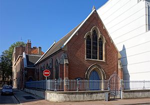
Church of Saint-Étienne, Lille
Church in Lille, France
Distance: Approx. 687 meters
Latitude and longitude: 50.63515833,3.05978611
The Church of Saint-Étienne, Lille (French: Église Saint-Étienne de Lille) is a Roman Catholic church located on the rue de l'Hôpital Militaire in Lille, France. It has been classed as a monument historique since 1987 and is dedicated to Saint Stephen. It is one of the largest Jesuit churches in France.

Siege of Lille (1792)
Battle
Distance: Approx. 176 meters
Latitude and longitude: 50.62777778,3.05833333
The siege of Lille (25 September – 8 October 1792) saw a Republican French garrison under Jean-Baptiste André Ruault de La Bonnerie hold Lille against an assault by a Habsburg army commanded by Duke Albert of Saxe-Teschen. Though the city was fiercely bombarded, the French successfully withstood the Austrian attack in the action. Because the Austrians were unable to completely encircle the city, the French were able to continuously send in reinforcements.
Wazemmes
Distance: Approx. 569 meters
Latitude and longitude: 50.62611111,3.05083333
Wazemmes is a former commune in the Nord department in northern France, merged into Lille in 1858. It is a cosmopolitan neighborhood, with a significant population of Chinese immigrants.
Christ Church, Lille
Distance: Approx. 641 meters
Latitude and longitude: 50.6302,3.0662
Christ Church Lille is an English-speaking Anglican Church located in the city of Lille in Nord-Pas-de-Calais, the Flemish area of France. Christ Church Lille is part of the Church of England, Diocese in Europe.
Canton of Lille-5
Distance: Approx. 520 meters
Latitude and longitude: 50.63,3.05
The canton of Lille-5 is an administrative division of the Nord department, northern France. It was created at the French canton reorganisation which came into effect in March 2015. Its seat is in Lille.

École supérieure de journalisme de Lille
Distance: Approx. 477 meters
Latitude and longitude: 50.62880694,3.06399194
The École supérieure de journalisme (ESJ Lille) (in English: Superior School of Journalism of Lille) is a private non-profit institution of higher education, a French Grande École in Lille dedicated to journalism and related studies. The ESJ is a graduate school of the University of Lille as part of a public-private partnership. It has been elected best French journalism school in 2013 by Le Figaro.

Saint-Joseph Chapel of Saint-Paul College in Lille
Demolished chapel in Lille, France
Distance: Approx. 760 meters
Latitude and longitude: 50.6335,3.0489
The Saint-Joseph Chapel was a historic church on the grounds of Saint-Paul College in Lille, France. It was built in 1887, and was demolished in February 2021 to build a new campus.
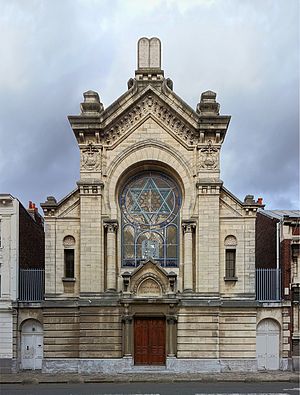
Lille Synagogue
Synagogue located in Nord, in France
Distance: Approx. 582 meters
Latitude and longitude: 50.6284,3.0654
Lille Synagogue (French: Synagogue de Lille) is a Jewish congregation and synagogue, located at 5, rue Auguste Angellie, in Lille, in the Hauts-de-France region of France. The congregation worships in the Ashkenazi rite.
Weather in this IP's area
drizzle
13 Celsius
13 Celsius
12 Celsius
14 Celsius
1014 hPa
88 %
1014 hPa
1011 hPa
6000 meters
4.63 m/s
310 degree
100 %
08:15:43
18:49:40