Country:
 Germany
Region:
City:
Latitude and Longitude:
Time Zone:
Postal Code:
IP information under different IP Channel
ip-api
Country
Region
City
ASN
Time Zone
ISP
Blacklist
Proxy
Latitude
Longitude
Postal
Route
IPinfo
Country
Region
City
ASN
Time Zone
ISP
Blacklist
Proxy
Latitude
Longitude
Postal
Route
MaxMind
Country
Region
City
ASN
Time Zone
ISP
Blacklist
Proxy
Latitude
Longitude
Postal
Route
Luminati
Country
DEASN
Time Zone
Europe/Berlin
ISP
Hetzner Online GmbH
Latitude
Longitude
Postal
db-ip
Country
Region
City
ASN
Time Zone
ISP
Blacklist
Proxy
Latitude
Longitude
Postal
Route
ipdata
Country
Region
City
ASN
Time Zone
ISP
Blacklist
Proxy
Latitude
Longitude
Postal
Route
Popular places and events near this IP address
Roth (district)
District in Bavaria, Germany
Distance: Approx. 8468 meters
Latitude and longitude: 49.25,11.08
Roth is a Landkreis (district) in Middle Franconia, Bavaria, Germany. It is bounded by (from the northeast and clockwise) the districts of Nürnberger Land, Neumarkt, Eichstätt, Weißenburg-Gunzenhausen, Ansbach and Fürth, and the cities of Schwabach and Nürnberg. In medieval times the area was ruled by many lords.

Abenberg
Town in Bavaria, Germany
Distance: Approx. 825 meters
Latitude and longitude: 49.25,10.96666667
Abenberg (German: [ˈaːbm̩bɛʁk] ) is a town in the Middle Franconian district of Roth, in Bavaria, Germany. It is situated 9 km west of Roth bei Nürnberg and 25 km southwest of Nuremberg.

Spalt
Town in Bavaria, Germany
Distance: Approx. 8117 meters
Latitude and longitude: 49.17388889,10.9275
Spalt (Franconian dialect: Schbåld) is a town in the district of Roth, in Bavaria, Germany. It is situated 19 km southwest of Schwabach. Spalt is famous for growing hops for brewing beer.

Büchenbach
Municipality in Bavaria, Germany
Distance: Approx. 7919 meters
Latitude and longitude: 49.26666667,11.06666667
Büchenbach is a municipality in the district of Roth, in Bavaria, Germany.

Georgensgmünd
Municipality in Bavaria, Germany
Distance: Approx. 7119 meters
Latitude and longitude: 49.18333333,11
Georgensgmünd is a municipality in the district of Roth, in Bavaria, Germany.

Kammerstein
Municipality in Bavaria, Germany
Distance: Approx. 4516 meters
Latitude and longitude: 49.28333333,10.96666667
Kammerstein is a municipality in the district of Roth in Bavaria in Germany.

Swabian Rezat
River in Germany
Distance: Approx. 7409 meters
Latitude and longitude: 49.18805556,11.02194444
The Swabian Rezat (German: Schwäbische Rezat, pronounced [ˈʃvɛːbɪʃə ˈʁɛtsat]) is a 33.3-kilometre-long river in southern Germany (Bavaria). It is the southern, right source river of the Rednitz. It rises in the Franconian Jura hills, near Weißenburg in Bayern.

Aurach (Rednitz)
River in Germany
Distance: Approx. 8603 meters
Latitude and longitude: 49.2542,11.0811
Aurach (German pronunciation: [ˈaʊ̯ʁax] ) is a river in the Bavarian Landkreise (districts) of Ansbach and Roth, Germany. The name means "river, where the Aurochs' graze" (Old High German ūr = Auerochs and aha = flowing water). The Aurach originates about 1 kilometre (0.6 mi) west of Petersaurach, Middle Franconia at an altitude of 452 metres (1,483 ft) above sea level.

Roth (Rednitz)
River in Germany
Distance: Approx. 8973 meters
Latitude and longitude: 49.2481,11.0872
Roth is a river of Bavaria, Germany. It is a right tributary of the Rednitz in the town Roth.
Stadtbrauerei Spalt
German brewery
Distance: Approx. 8121 meters
Latitude and longitude: 49.17444444,10.925
The Stadtbrauerei Spalt (Spalt City Brewery in German) is a brewery in the Middle Franconian town of Spalt which was created in the year 1879 through the merger of numerous smaller breweries. Since 2006, it is the last municipally owned brewery in Germany. For brewing, the local hop variety "Spalter Aromahopfen" is used, which is the town's most important trade good.
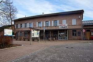
Georgensgmünd station
Railway station in Germany
Distance: Approx. 7643 meters
Latitude and longitude: 49.1831,11.0159
Georgensgmünd station is a railway station in the municipality of Georgensgmünd, located in the Roth district in Middle Franconia, Bavaria, Germany.
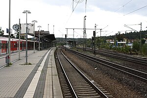
Roth station
Railway station in Roth, Germany
Distance: Approx. 8628 meters
Latitude and longitude: 49.24114,11.08268806
Roth station is a railway station in the municipality of Roth, located in the Roth district in Middle Franconia, Germany. The station is located at the junction of the Nuremberg–Roth, Nuremberg–Augsburg, and Roth–Greding lines.
Weather in this IP's area
light rain
9 Celsius
8 Celsius
9 Celsius
10 Celsius
1022 hPa
97 %
1022 hPa
973 hPa
10000 meters
2.42 m/s
8.22 m/s
289 degree
100 %
06:54:21
19:27:40