Country:
 Germany
Region:
City:
Latitude and Longitude:
Time Zone:
Postal Code:
IP information under different IP Channel
ip-api
Country
Region
City
ASN
Time Zone
ISP
Blacklist
Proxy
Latitude
Longitude
Postal
Route
IPinfo
Country
Region
City
ASN
Time Zone
ISP
Blacklist
Proxy
Latitude
Longitude
Postal
Route
MaxMind
Country
Region
City
ASN
Time Zone
ISP
Blacklist
Proxy
Latitude
Longitude
Postal
Route
Luminati
Country
DERegion
be
City
berlin
ASN
Time Zone
Europe/Berlin
ISP
Buchholz und Suenderhauf GbR
Latitude
Longitude
Postal
db-ip
Country
Region
City
ASN
Time Zone
ISP
Blacklist
Proxy
Latitude
Longitude
Postal
Route
ipdata
Country
Region
City
ASN
Time Zone
ISP
Blacklist
Proxy
Latitude
Longitude
Postal
Route
Popular places and events near this IP address

Pankstraße (Berlin U-Bahn)
Station of the Berlin U-Bahn
Distance: Approx. 881 meters
Latitude and longitude: 52.55222222,13.38166667
Pankstraße is a Berlin U-Bahn station located on the U8. It was opened on 5 October 1977 (Rümmler) with the line's extension from Gesundbrunnen to Osloer Straße. The station's name derives from its location: It sits under the intersection of Pankstraße and Badstraße.

Voltastraße (Berlin U-Bahn)
Station of the Berlin U-Bahn
Distance: Approx. 546 meters
Latitude and longitude: 52.54222222,13.39305556
Voltastraße is a Berlin U-Bahn station located on the U8. Built in 1914 but not opened until 1930 (a delay caused by the First World War), it has granite columns and is 4.5 metres (15 ft) below the street. After the completion of the Berlin Wall, line U8 was severely curtailed.

Bernauer Straße (Berlin U-Bahn)
Station of the Berlin U-Bahn
Distance: Approx. 1078 meters
Latitude and longitude: 52.5375,13.39666667
Bernauer Straße is a Berlin U-Bahn station located on the U8.

Berlin Gesundbrunnen station
Railway station in Berlin
Distance: Approx. 478 meters
Latitude and longitude: 52.54861111,13.38944444
Berlin Gesundbrunnen station (German: Bahnhof Berlin Gesundbrunnen) is a railway station in Berlin, Germany. It is situated in the Gesundbrunnen district, part of the central Mitte borough, as an interconnection point between the northern Ringbahn and Nord-Süd Tunnel lines of the Berlin S-Bahn, as well as a regional and long distance station of the Deutsche Bahn network. The station is operated by the DB Station&Service subsidiary of Deutsche Bahn AG and is classified as a Category 1 station, one of 21 in Germany and four in Berlin, the others being Berlin Hauptbahnhof, Berlin Südkreuz and Berlin Ostbahnhof.

Berlin Humboldthain station
Railway station in Mitte, Germany
Distance: Approx. 458 meters
Latitude and longitude: 52.545,13.37944444
Berlin Humboldthain station (German: Bahnhof Berlin Humboldthain) is a railway station in the city of Berlin, Germany. It is served by the Berlin S-Bahn lines S1,S2,S25 and S26. It is also served by local bus route 247.
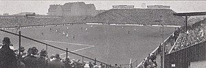
Stadion am Gesundbrunnen
Distance: Approx. 752 meters
Latitude and longitude: 52.54998,13.39334
Stadion am Gesundbrunnen was a multi-use stadium in the Gesundbrunnen locality of Berlin, Germany. It was initially used as the stadium of Hertha BSC matches. During the 1936 Summer Olympics, it hosted some of the football matches.
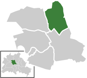
Gesundbrunnen (Berlin)
Quarter of Berlin in Germany
Distance: Approx. 506 meters
Latitude and longitude: 52.54861111,13.39027778
Gesundbrunnen (German: [ɡəˈzʊntˌbʁʊnən] , literally "health springs"; colloquially Plumpe, "pump") is a locality (Ortsteil) of Berlin in the borough (Bezirk) of Mitte. It was created as a separate entity by the 2001 administrative reform, formerly the eastern half of the former Wedding district (merged into Mitte) and locality. Gesundbrunnen has the highest percentage of non-German residents of any Berlin locality, at 35.1% as of the end of 2008.

Chapel of Reconciliation
Distance: Approx. 1071 meters
Latitude and longitude: 52.53583333,13.39194444
The Chapel of Reconciliation (German: Kapelle der Versöhnung) is a place of worship in Berlin, Germany. It stands on the site of the old Church of Reconciliation (de) (German: Versöhnungskirche), on Bernauer Strasse in the Mitte district.

Ackerstraße
Street in Berlin, Germany
Distance: Approx. 1083 meters
Latitude and longitude: 52.535401,13.390317
The Ackerstraße is a street in Berlin which runs northwest from near the Liesenstraße – Scheringstraße traffic circle in Gesundbrunnen to Invalidenstraße, where it turns south, terminating at the Linienstraße in Mitte.

Gedenkstätte Berliner Mauer
Berlin Wall Memorial built in 1998
Distance: Approx. 1117 meters
Latitude and longitude: 52.535,13.38972222
The Gedenkstätte Berliner Mauer (Berlin Wall Memorial) commemorates the division of Berlin by the Berlin Wall and the deaths that occurred there. The monument was created in 1998 by the Federal Republic of Germany and the Federal State of Berlin. It is located on Bernauer Straße at the corner of Ackerstraße and includes a Chapel of Reconciliation, the Berlin Wall Documentation Centre, a 60-metre (200 ft) section of the former border, a window of remembrance and a visitor center.

Tunnel 57
Tunnel under the Berlin Wall
Distance: Approx. 1046 meters
Latitude and longitude: 52.53628333,13.39271944
Tunnel 57 was a tunnel under the Berlin Wall that on 3 and 4 October 1964 was the location of a mass escape by 57 East Berlin citizens to West Berlin. It was built from the basement of an empty bakery at 97 Bernauer Straße in West Berlin, under the Berlin Wall – which at that time and place consisted of empty, bricked-up apartment buildings on the east side of Bernauer Straße – all the way to a disused outhouse in the rear courtyard at 55 Strelitzer Straße in East Berlin. At a depth of 12 meters (39 ft) and a length of 145 meters (476 ft), Tunnel 57 was the longest, deepest and most expensive flight tunnel built in Berlin.

St. Sebastian Church, Berlin
Distance: Approx. 788 meters
Latitude and longitude: 52.5379,13.38361
St. Sebastian or the Sebastiankirche is a neo-Gothic parish church and state monument on Gartenplatz in Berlin-Gesundbrunnen. It was built between 1890 and 1893 to have capacity for 1000 seats or 3000 standing.
Weather in this IP's area
overcast clouds
31 Celsius
31 Celsius
29 Celsius
32 Celsius
1009 hPa
44 %
1009 hPa
1003 hPa
10000 meters
4.47 m/s
7.15 m/s
137 degree
94 %
06:29:34
19:38:53