185.237.91.193 - IP Lookup: Free IP Address Lookup, Postal Code Lookup, IP Location Lookup, IP ASN, Public IP
Country:
Region:
City:
Location:
Time Zone:
Postal Code:
IP information under different IP Channel
ip-api
Country
Region
City
ASN
Time Zone
ISP
Blacklist
Proxy
Latitude
Longitude
Postal
Route
Luminati
Country
Region
eng
City
greenwich
ASN
Time Zone
Europe/London
ISP
Merula Limited
Latitude
Longitude
Postal
IPinfo
Country
Region
City
ASN
Time Zone
ISP
Blacklist
Proxy
Latitude
Longitude
Postal
Route
IP2Location
185.237.91.193Country
Region
england
City
clevedon
Time Zone
Europe/London
ISP
Language
User-Agent
Latitude
Longitude
Postal
db-ip
Country
Region
City
ASN
Time Zone
ISP
Blacklist
Proxy
Latitude
Longitude
Postal
Route
ipdata
Country
Region
City
ASN
Time Zone
ISP
Blacklist
Proxy
Latitude
Longitude
Postal
Route
Popular places and events near this IP address

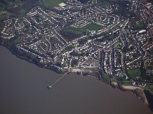
Clevedon
Town and civil parish in Somerset, England
Distance: Approx. 378 meters
Latitude and longitude: 51.438,-2.854
Clevedon (, KLEEV-dən) is a seaside town and civil parish in the unitary authority of North Somerset, England. It recorded a parish population of 21,281 in the United Kingdom Census 2011, estimated at 21,442 in 2019. It lies along the Severn Estuary, among small hills that include Church Hill, Wain's Hill (topped by the remains of an Iron Age hill fort), Dial Hill, Strawberry Hill, Castle Hill, Hangstone Hill and Court Hill, a Site of Special Scientific Interest with overlaid Pleistocene deposits.

Clevedon Pier
Grade I listed pier in North Somerset, UK
Distance: Approx. 490 meters
Latitude and longitude: 51.4432,-2.8632
Clevedon Pier is a seaside pier in the town of Clevedon, Somerset, England on the east shore of the Severn Estuary. It was described by Sir John Betjeman, as "the most beautiful pier in England" and was designated a Grade I listed building in 2001. The pier was built during the 1860s to attract tourists and provide a ferry port for rail passengers to South Wales.

Curzon Community Cinema, Clevedon
Distance: Approx. 568 meters
Latitude and longitude: 51.43573889,-2.85502222
The Curzon Cinema & Arts, in Clevedon, North Somerset, England, is one of the oldest continually running purpose-built cinemas in the world.

Clevedon Shore
Distance: Approx. 395 meters
Latitude and longitude: 51.44292,-2.86181
Clevedon Shore (grid reference ST402719) is a 0.38 hectare geological Site of Special Scientific Interest adjacent to the Severn Estuary at Clevedon, North Somerset, notified in 1991. It is the side of a mineralised fault, which runs east-west adjacent to the pier, and forms a small cliff feature in dolomitic conglomerate on the north side of Clevedon Beach, containing cream to pink baryte together with sulphides. The minerals identified at the site include: haematite, chalcopyrite, tennantite, galena, tetrahedrite, bornite, pyrite, marcasite, enargite and sphalerite.

Royal Pier Hotel, Clevedon
Historic site in Clevedon, North Somerset
Distance: Approx. 469 meters
Latitude and longitude: 51.44444444,-2.86027778
The Royal Pier Hotel is a Grade II listed building in Clevedon, England.

Clock Tower, Clevedon
Victorian-era English structure in Somerset
Distance: Approx. 606 meters
Latitude and longitude: 51.43630556,-2.85213889
A Victorian Clock Tower is located in the heart of the Triangle shopping centre in Clevedon, Somerset, England. It has been designated as a Grade II listed building.
St Brandon's School
Distance: Approx. 596 meters
Latitude and longitude: 51.43722222,-2.86416667
St Brandon's School was an independent school incorporating an infant and junior school and a senior boarding school for girls, located in the town of Clevedon in Somerset, in South West England. The school was opened in 1831 and closed in 2004.

Clevedon Hall
Victorian mansion in Clevedon, Somerset, England
Distance: Approx. 679 meters
Latitude and longitude: 51.43583333,-2.86361111
Clevedon Hall is a mansion with 17 acres (6.9 ha) of land in Clevedon, North Somerset, England. It is a Grade II* listed building. It is not to be confused with Cliveden on the Thames near Taplow, nor other houses with similar names.

Christ Church, Clevedon
Church in Somerset, England
Distance: Approx. 427 meters
Latitude and longitude: 51.439,-2.8519
Christ Church in Clevedon, within the English county of Somerset was built between 1838 and 1839 by Richard Charles Hussey and Thomas Rickman and revised by George Phillips Manners and John Elkington Gill in the 1850s. It is a Grade II* listed building.

Church of St John the Evangelist, Clevedon
Church in Somerset, England
Distance: Approx. 468 meters
Latitude and longitude: 51.4367,-2.855
The Church of St John the Evangelist is a Church of England church in Clevedon, Somerset, England. Designed by William Butterfield, it was built in 1876–78 at the expense of Sir Arthur Elton and has been a Grade II* listed building since 1976.

Clevedon railway station (WCP)
Disused railway station in Clevedon, North Somerset
Distance: Approx. 642 meters
Latitude and longitude: 51.4351,-2.8547
Clevedon railway station served the town of Clevedon, North Somerset, England, from 1897 to 1940 on the Weston, Clevedon and Portishead Railway.

Clevedon Town Hall
Municipal building in Clevedon, Somerset, England
Distance: Approx. 736 meters
Latitude and longitude: 51.4372,-2.8484
Clevedon Town Hall is a municipal building in Old Street in Clevedon, a town in Somerset in England. The building, which was commissioned as a primary school but currently accommodates the offices and meeting place of Clevedon Town Council, is a Grade II listed building.
Weather in this IP's area
overcast clouds
9 Celsius
6 Celsius
8 Celsius
9 Celsius
1030 hPa
94 %
1030 hPa
1026 hPa
10000 meters
4.63 m/s
250 degree
100 %