Country:
 Belgium
Region:
City:
Latitude and Longitude:
Time Zone:
Postal Code:
IP information under different IP Channel
ip-api
Country
Region
City
ASN
Time Zone
ISP
Blacklist
Proxy
Latitude
Longitude
Postal
Route
IPinfo
Country
Region
City
ASN
Time Zone
ISP
Blacklist
Proxy
Latitude
Longitude
Postal
Route
MaxMind
Country
Region
City
ASN
Time Zone
ISP
Blacklist
Proxy
Latitude
Longitude
Postal
Route
Luminati
Country
BEASN
Time Zone
Europe/Brussels
ISP
Syntax Bvba
Latitude
Longitude
Postal
db-ip
Country
Region
City
ASN
Time Zone
ISP
Blacklist
Proxy
Latitude
Longitude
Postal
Route
ipdata
Country
Region
City
ASN
Time Zone
ISP
Blacklist
Proxy
Latitude
Longitude
Postal
Route
Popular places and events near this IP address

Brasschaat
Municipality in Flemish Community, Belgium
Distance: Approx. 3515 meters
Latitude and longitude: 51.3,4.5
Brasschaat (Dutch pronunciation: [brɑˈsxaːt] ) is a municipality located in Flanders, one of the three regions of Belgium, and in the Flemish province of Antwerp. The municipality only comprises the town of Brasschaat proper. In November 2006, Brasschaat won the LivCom-Award 2006 for the most livable municipality in the world.

Kalmthout
Municipality in Flemish Community, Belgium
Distance: Approx. 7249 meters
Latitude and longitude: 51.38333333,4.46666667
Kalmthout (Dutch pronunciation: [ˈkɑl(ə)mtɦʌut]) is a municipality in the Belgian province of Antwerp. The municipality comprises the villages of Kalmthout, Achterbroek, Heide, and Nieuwmoer. In 2021, Kalmthout had a population of 19,020.

Kapellen, Belgium
Municipality in Flemish Community, Belgium
Distance: Approx. 6331 meters
Latitude and longitude: 51.31666667,4.43333333
Kapellen (Dutch pronunciation: [kaːˈpɛlə(n)] , old spelling: Cappellen) is a municipality in the Belgian province of Antwerp. The municipality lies in the Campine in the northern part of the province. Kapellen consists only of the town of Kapellen proper.
Belgian Open (golf)
Golf tournament
Distance: Approx. 6389 meters
Latitude and longitude: 51.2807,4.5737
The Belgian Open is a men's golf tournament which has been played intermittently from 1910 to 2000. All editions since 1978 have been part of the European Tour. After not having been played since 2000, it returned in 2018 as the Belgian Knockout, hosted by PietersProductions, along with its co-founder, Belgian professional golfer Thomas Pieters.

Brecht Abbey
Trappist abbey in Belgium
Distance: Approx. 7763 meters
Latitude and longitude: 51.316523,4.6323994
Brecht Abbey, also known as the Abbey of Our Lady of Nazareth, is an abbey of Trappistine nuns located in Brecht, in the Campine region of the province of Antwerp (Flanders, Belgium). Life in the abbey is characterized by prayer, reading and manual work, the three basic elements of Trappist life.
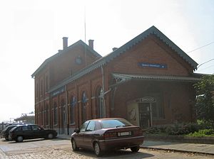
Kalmthout railway station
Railway station in Antwerp, Belgium
Distance: Approx. 7958 meters
Latitude and longitude: 51.39083333,4.46694444
Kalmthout is a railway station in the town of Kalmthout, Antwerp, Belgium. The station opened on 26 June 1854 on the Antwerp–Lage Zwaluwe railway, known in Belgium as Line 12.

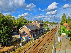
Kapellen railway station
Railway station in Antwerp, Belgium
Distance: Approx. 6474 meters
Latitude and longitude: 51.31333333,4.4325
Kapellen is a railway station in the town of Kapellen, Antwerp, Belgium. The station opened on 26 June 1854 on the Antwerp–Lage Zwaluwe railway, known in Belgium as Line 12. Just outside the station, to the north, on the east-side there is a single rail fork towards the military domain of Brasschaat.
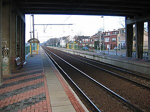
Ekeren railway station
Railway station in Antwerp, Belgium
Distance: Approx. 8042 meters
Latitude and longitude: 51.28166667,4.43416667
Ekeren is a railway station in the town of Ekeren, Antwerp, Belgium. The station opened on 3 July 1854 on the Antwerp–Lage Zwaluwe railway, known in Belgium as Line 12.

Kijkuit railway station
Railway station in Antwerp, Belgium
Distance: Approx. 6815 meters
Latitude and longitude: 51.37888889,4.46722222
Kijkuit is a railway station in the town of Kalmthout, Antwerp, Belgium. The station opened on 15 May 1933 on the Antwerp–Lage Zwaluwe railway, known in Belgium as Line 12.
Sint-Mariaburg railway station
Railway station in Antwerp, Belgium
Distance: Approx. 7357 meters
Latitude and longitude: 51.29138889,4.43472222
Sint-Mariaburg is a railway station in the town of Ekeren, Antwerp, Belgium. The station opened in 1934 on the Antwerp–Lage Zwaluwe railway, known in Belgium as Line 12.
Brasschaat Airfield
Former military, currently civilian airfield in Belgium
Distance: Approx. 1886 meters
Latitude and longitude: 51.34083333,4.50416667
Brasschaat Airfield (Dutch: Vliegveld Brasschaat, (ICAO: EBBT)) is an airfield located 4 kilometres (2 mi) north of Brasschaat, Antwerp, Belgium. Formerly the base of the Belgian Army Flying Service, it is today home to recreational flying, including gliders and microlights.
Rugbyclub Diabolos
Rugby team
Distance: Approx. 7022 meters
Latitude and longitude: 51.269866,4.56043727
Rugbyclub Diabolos is a Belgian rugby club in Schilde, founded in 1991. The club is affiliated to the Belgian Rugby Federation through its flemish branch Rugby Vlaanderen. The first teams, both men´s and women´s, played in 2022-2023 in the Belgian third division (D3).
Weather in this IP's area
drizzle
12 Celsius
12 Celsius
12 Celsius
13 Celsius
1005 hPa
94 %
1005 hPa
1003 hPa
10000 meters
7.2 m/s
230 degree
75 %
07:42:49
19:19:58