Country:
 Sweden
Region:
City:
Latitude and Longitude:
Time Zone:
Postal Code:
IP information under different IP Channel
ip-api
Country
Region
City
ASN
Time Zone
ISP
Blacklist
Proxy
Latitude
Longitude
Postal
Route
IPinfo
Country
Region
City
ASN
Time Zone
ISP
Blacklist
Proxy
Latitude
Longitude
Postal
Route
MaxMind
Country
Region
City
ASN
Time Zone
ISP
Blacklist
Proxy
Latitude
Longitude
Postal
Route
Luminati
Country
SEASN
Time Zone
Europe/Stockholm
ISP
GlobalConnect AB
Latitude
Longitude
Postal
db-ip
Country
Region
City
ASN
Time Zone
ISP
Blacklist
Proxy
Latitude
Longitude
Postal
Route
ipdata
Country
Region
City
ASN
Time Zone
ISP
Blacklist
Proxy
Latitude
Longitude
Postal
Route
Popular places and events near this IP address

Stockholm Concert Hall
Building in Stockholm, Sweden
Distance: Approx. 225 meters
Latitude and longitude: 59.335,18.06305556
The Stockholm Concert Hall (Swedish: Stockholms konserthus) is the main hall for orchestral music in Stockholm, Sweden. With a design by Ivar Tengbom chosen in competition, inaugurated in 1926, the Hall is home to the Royal Stockholm Philharmonic Orchestra. It is also where the awarding ceremonies for the Nobel Prize and the Polar Music Prize are held annually.

Hötorget
Square in central Stockholm, Sweden
Distance: Approx. 224 meters
Latitude and longitude: 59.335,18.063
Hötorget (Haymarket) is a city square in the center of Stockholm, Sweden that has been transitioning since the Early Medieval Period.

Adolf Fredrik Church
Church in Stockholm, Sweden
Distance: Approx. 127 meters
Latitude and longitude: 59.33777778,18.06027778
Adolf Fredrik Church (Swedish: Adolf Fredriks kyrka) is a church in central Stockholm, Sweden, named after Adolf Frederick. It was built in 1768–1774, replacing a wooden chapel from 1674, which was dedicated to Saint Olof. It was inaugurated on 27 November 1774.

Assassination of Olof Palme
1986 murder of the Prime Minister of Sweden
Distance: Approx. 71 meters
Latitude and longitude: 59.3366,18.0628
On 28 February 1986, at 23:21 CET (22:21 UTC), Olof Palme, Prime Minister of Sweden, was fatally wounded by a single gunshot while walking home from a cinema with his wife Lisbeth Palme on the central Stockholm street Sveavägen. Lisbeth Palme was slightly wounded by a second shot. The couple did not have bodyguards with them.

Brunkeberg Tunnel
Distance: Approx. 156 meters
Latitude and longitude: 59.33694444,18.06444444
The Brunkeberg Tunnel in Norrmalm, Stockholm, is a 231-metre-long passageway for pedestrians through the esker Brunkebergsåsen.

Kungsgatan, Stockholm
Street in central Stockholm, Sweden
Distance: Approx. 187 meters
Latitude and longitude: 59.33525,18.06233333
Kungsgatan (Swedish for "King's Street") is a street address in central Stockholm, Sweden. It was formerly a red-light district and is currently a busy shopping street. At its western end it is connected to Kungsholmen by Kungsbron bridge, from where it stretches east to Stureplan public square.

Kungstornen
Commercial offices in Stockholm, Sweden
Distance: Approx. 236 meters
Latitude and longitude: 59.33611111,18.06555556
Kungstornen (King's Towers) are twin tower skyscrapers, individually named Norra Kungstornet (Northern King's Tower) and Södra Kungstornet (Southern King's Tower), in Norrmalm, Stockholm. The 16-storey Norra Kungstornet is 60 m (200 ft) and was built between 1919 and 1924; and the taller 17-storey, 61 m (200 ft) Södra Kungstornet was built between 1924 and 1925. Together, they are considered the first modern skyscrapers in Europe.

Brunkebergsåsen
Distance: Approx. 190 meters
Latitude and longitude: 59.33805556,18.06416667
Brunkebergsåsen was an esker that once reached over much of Stockholm's Norrmalm district. Geologically, it is a part of the much larger Stockholmsåsen. It formed a considerable obstacle to traffic, effectively dividing Norrmalm into a western and an eastern part.

Tunnelgatan
Distance: Approx. 96 meters
Latitude and longitude: 59.33678333,18.06338333
Tunnelgatan (Tunnel Street) is a street in Stockholm, Sweden, which stretches from Sveavägen to the Brunkeberg Tunnel. Tunnelgatan was named after the Brunkeberg tunnel which opened in 1886. The previous name was Barnhus trädgårdsgata (Orphanage garden street), after the orphanage at Norra Bantorget.

2010 Stockholm bombings
Terrorist suicide attack
Distance: Approx. 173 meters
Latitude and longitude: 59.33569444,18.05977778
On 11 December 2010, two bombs exploded in central Stockholm, killing the bomber. Swedish Minister for Foreign Affairs Carl Bildt and the Swedish Security Service (SÄPO) described the bombings as acts of terrorism. Taimour Abdulwahab al-Abdaly, an Iraqi-born Swedish citizen, is suspected of carrying out the bombing.
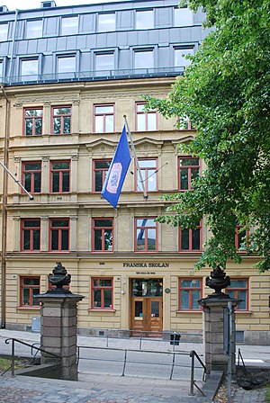
Franska Skolan
School in Stockholm, Sweden
Distance: Approx. 215 meters
Latitude and longitude: 59.33863,18.063371
Franska Skolan (English: French School) is a private school located in Stockholm, Sweden. It was founded in 1862. French school (French: École Française) is a school located on Döbelnsgatan 9 in Stockholm, founded in 1862 originally as a girls' school of the Roman Catholic religious congregation Sisters of St.
Stora Barnhuset
Distance: Approx. 223 meters
Latitude and longitude: 59.3367,18.0578
Stora Barnhuset (literally: "Great Children's Home"), from 1785 known as Allmänna Barnhuset ("Public Children's Home"), was Sweden's largest orphanage, founded 1633 in Stockholm and active until 1922. The charitable foundation of the orphanage still exists, now supporting research associated with children's care.
Weather in this IP's area
fog
5 Celsius
5 Celsius
4 Celsius
7 Celsius
1019 hPa
98 %
1019 hPa
1015 hPa
1400 meters
93 %
07:02:29
18:09:27