185.235.144.5 - IP Lookup: Free IP Address Lookup, Postal Code Lookup, IP Location Lookup, IP ASN, Public IP
Country:
 Netherlands
Region:
City:
Location:
Time Zone:
Postal Code:
ISP:
ASN:
language:
User-Agent:
Proxy IP:
Blacklist:
IP information under different IP Channel
ip-api
Country
Region
City
ASN
Time Zone
ISP
Blacklist
Proxy
Latitude
Longitude
Postal
Route
db-ip
Country
Region
City
ASN
Time Zone
ISP
Blacklist
Proxy
Latitude
Longitude
Postal
Route
IPinfo
Country
Region
City
ASN
Time Zone
ISP
Blacklist
Proxy
Latitude
Longitude
Postal
Route
IP2Location
185.235.144.5Country
nlRegion
groningen
City
zuidhorn
Time Zone
Europe/Amsterdam
ISP
Language
User-Agent
Latitude
Longitude
Postal
ipdata
Country
Region
City
ASN
Time Zone
ISP
Blacklist
Proxy
Latitude
Longitude
Postal
Route
Popular places and events near this IP address

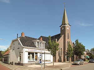
Zuidhorn
Place in Groningen, Netherlands
Distance: Approx. 412 meters
Latitude and longitude: 53.25,6.4
Zuidhorn (Dutch pronunciation: [zœytˈɦɔr(ə)n] ; Gronings: Zuudhörn [zytˈɦœːn]) is a town and former municipality in the northeastern Netherlands. The town largely depends on the city of Groningen. A railway line, operated by Arriva, connects the town with Leeuwarden in Friesland and Groningen.
Aduard
Village in Groningen, Netherlands
Distance: Approx. 3913 meters
Latitude and longitude: 53.25472222,6.46
Aduard (Dutch: [ˈaːdyɑrt]; Gronings: Auwerd [ˈau̯wərt]) is a village in the municipality of Westerkwartier, in the Netherlands. It is located about 8 km northwest of Groningen. As of 1 January 2023, it had a population of 2,095.

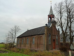
Zuidhorn railway station
Railway station in the Netherlands
Distance: Approx. 258 meters
Latitude and longitude: 53.24833333,6.40555556
Zuidhorn (Dutch pronunciation: [ˈzœytɦɔr(ə)n] ; abbreviation: Zh) is a railway station located in Zuidhorn in the Netherlands. The station was opened on 1 June 1866 and is located on the Harlingen–Nieuweschans railway between Leeuwarden and Groningen. The train service is operated by Arriva.

Herberg Onder de Linden
Restaurant in Aduard, Netherlands
Distance: Approx. 3868 meters
Latitude and longitude: 53.25823056,6.45758611
Herberg Onder de Linden is a restaurant located in Aduard, in the Netherlands. It is a fine dining restaurant that holds a Michelin star rating since 1992. GaultMillau awarded the restaurant 16.0 out of 20 points.

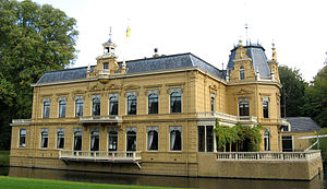
Piloersemaborg
Distance: Approx. 3420 meters
Latitude and longitude: 53.27612222,6.417575
The Piloersemaborg (Dutch pronunciation: [piˈluːrsəmaːˌbɔr(ə)x]; Borg of Piloersema) is a 17th-century borg (castle) in the village of Den Ham in Groningen in the Netherlands. It currently houses a restaurant.

Aduard Abbey
Building in Netherlands
Distance: Approx. 3892 meters
Latitude and longitude: 53.25629167,6.45899444
Aduard Abbey (Dutch: Abdij van Aduard, Abdij Sint-Bernardus in Aduard) is a former Cistercian abbey in the village of Aduard about 8 kilometres to the north-west of Groningen in the Netherlands, founded in 1192 and dissolved in 1580.
Westerkwartier (municipality)
Municipality in Groningen, Netherlands
Distance: Approx. 4116 meters
Latitude and longitude: 53.225,6.35277778
Westerkwartier (West Frisian: Westerkertier) is a municipality in the Netherlands, in the province of Groningen. The municipality was formed on 1 January 2019, by the merger of the municipalities of Grootegast, Leek, Marum, Zuidhorn and partly Winsum.

Noordhorn
Village in Groningen, Netherlands
Distance: Approx. 1408 meters
Latitude and longitude: 53.2582,6.394
Noordhorn (Gronings: Noordhörn) is a village in the Dutch province of Groningen. It is part of the municipality of Westerkwartier and is separated from Zuidhorn by the van Starkenborghkanaal.

Briltil
Village in Groningen, Netherlands
Distance: Approx. 1083 meters
Latitude and longitude: 53.24217,6.38842
Briltil (Dutch: [ˈbrɪltɪl]; Gronings: (de) Bril) is a village in the municipality of Westerkwartier in the province of Groningen in the Netherlands, founded around 1600. The name of the village comes from a drawbridge (til) over the Hoendiep to the region of the Bril (bril means 'swampy land') northwest of the bridge. As of 2021, Briltil had a population of 490.
Den Horn
Village in Groningen, Netherlands
Distance: Approx. 3400 meters
Latitude and longitude: 53.22659,6.44121
Den Horn (Dutch: [dɛn ˈɦɔr(ə)n]; Gronings: Den Hörn) is a small village in the municipality of Westerkwartier in the province of Groningen in the Netherlands. The village is quite isolated in the east of the municipality, just south of the railway line between Groningen and Leeuwarden. As of 2021, it had a population of 710.

Enumatil
Village in Groningen, Netherlands
Distance: Approx. 3469 meters
Latitude and longitude: 53.21666667,6.41666667
Enumatil (Dutch: [ˈeːnymaːtɪl]; Gronings: Aimtil or IJmentil) is a village in the municipality of Westerkwartier in the province of Groningen in the Netherlands. As of 2021, it had a population of 335. It is located to the south of Briltil and to the west of Den Horn.

Hoendiep
Canal in the Netherlands
Distance: Approx. 1767 meters
Latitude and longitude: 53.231111,6.397778
The Hoendiep (Dutch: [ˈɦundip]; Gronings: Houndaip) is a canal in the Dutch province of Groningen, located between the city of Groningen and Zuidhorn. Before 1938, the current section of the Van Starkenborgh Canal from Zuidhorn to the Frisian border was also called Hoendiep. The road on the south side of the Van Starkenborgh Canal is still called Hoendiep.
Weather in this IP's area
few clouds
-2 Celsius
-5 Celsius
-2 Celsius
-1 Celsius
1032 hPa
89 %
1032 hPa
1032 hPa
10000 meters
2.37 m/s
2.31 m/s
210 degree
24 %