Country:
Region:
City:
Latitude and Longitude:
Time Zone:
Postal Code:
IP information under different IP Channel
ip-api
Country
Region
City
ASN
Time Zone
ISP
Blacklist
Proxy
Latitude
Longitude
Postal
Route
Luminati
Country
ASN
Time Zone
Europe/Berlin
ISP
VSE NET GmbH
Latitude
Longitude
Postal
IPinfo
Country
Region
City
ASN
Time Zone
ISP
Blacklist
Proxy
Latitude
Longitude
Postal
Route
db-ip
Country
Region
City
ASN
Time Zone
ISP
Blacklist
Proxy
Latitude
Longitude
Postal
Route
ipdata
Country
Region
City
ASN
Time Zone
ISP
Blacklist
Proxy
Latitude
Longitude
Postal
Route
Popular places and events near this IP address
Osnabrück (district)
District in Lower Saxony, Germany
Distance: Approx. 4169 meters
Latitude and longitude: 52.33,8.17
Osnabrück (German: [ɔsnaˈbʁʏk] ) is a district (Landkreis) in the southwest of Lower Saxony, Germany. With 2,122 km2 it is the second largest district of Lower Saxony.
Karmann
German automobile and contract manufacturer
Distance: Approx. 5365 meters
Latitude and longitude: 52.26583333,8.07777778
Wilhelm Karmann GmbH, commonly known as Karmann, was a German automobile manufacturer and contract manufacturer based in Osnabrück, Germany. Founded by Wilhelm Karmann in 1901, the company specialised in various automotive roles, including design, production and assembly of components for a wide variety of automobile manufacturers, including Chrysler, Porsche, Mercedes-Benz and Volkswagen Group. The company was broken up in 2010, after filing for bankruptcy the previous year.

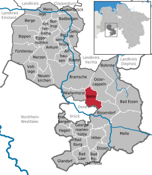
Belm
Municipality in Lower Saxony, Germany
Distance: Approx. 0 meters
Latitude and longitude: 52.3,8.13333333
Belm is a municipality in the district of Osnabrück, in Lower Saxony, Germany. It is located in the Wiehengebirge, approximately 7 km northeast of Osnabrück, and is therefore part of the city-agglomeration of Osnabrück. It is seated in the middle of the TERRA.vita Nature Park.

Stadion an der Bremer Brücke
Football stadium in Osnabrück, Germany
Distance: Approx. 4743 meters
Latitude and longitude: 52.28083333,8.07111111
Stadion an der Bremer Brücke or Bremer Brücke is a football stadium in the Schinkel district of Osnabrück, Germany. It is used mostly for football matches and is the home stadium of VfL Osnabrück. The stadium currently holds 16,100 people and was opened in 1933.

Prince-Bishopric of Osnabrück
Territory of the Holy Roman Empire (1225–1803)
Distance: Approx. 2061 meters
Latitude and longitude: 52.2833,8.1464
The Prince-Bishopric of Osnabrück (German: Hochstift Osnabrück; Fürstbistum Osnabrück, Bistum Osnabrück) was an ecclesiastical principality of the Holy Roman Empire from 1225 until 1803. It should not be confused with the Diocese of Osnabrück (Bistum Osnabrück), which was larger and over which the prince-bishop exercised only the spiritual authority of an ordinary bishop. It was named after its capital, Osnabrück.

Widukindland
Distance: Approx. 3029 meters
Latitude and longitude: 52.2931,8.0903
Widukindland is a district of Osnabrück, Germany. It is situated in the north-east of the city, on the slopes of the Schinkelberg (Schinkel Hill). It arose from the former boundaries of Schinkel.
Schinkel (Osnabrück district)
District of Osnabrück, Lower Saxony, Germany
Distance: Approx. 4272 meters
Latitude and longitude: 52.2792,8.0806
Schinkel is a district of Osnabrück, Germany, first mentioned in records in 1332. It is situated in the east of the city, into which it was incorporated on 1 April 1914. There are roughly 13,300 people in Schinkel.
Schinkel-Ost (Osnabrück district)
Distance: Approx. 4347 meters
Latitude and longitude: 52.2667,8.1
Schinkel-Ost is a district of Osnabrück, Germany. It originally lay within the former boundaries of Schinkel, which was incorporated into Osnabrück in 1914. Schinkel-Ost is home to roughly 3,500 residents.

Dodesheide
Town in Osnabrück, Lower Saxony, Germany
Distance: Approx. 4143 meters
Latitude and longitude: 52.3039,8.0728
Dodesheide is a town in the borough of Osnabrück, Germany; with a population of roughly 7,900 residents it is located to the north-east of the city. Its boundaries are delineated in the north by the Vehrter Landstraße, in the west by the landwehr – a former defensive line around the town consisting of a bank and ditches – in the south by the Sandbach and the Osnabrück-Bremen railway line; the city boundary itself marks its eastern border. It is made up of sections of the former districts of Schinkel and Haste.

Gartlage
District of Osnabrück, Lower Saxony, Germany
Distance: Approx. 4496 meters
Latitude and longitude: 52.2917,8.0687
Gartlage is a district of the city of Osnabrück, Lower Saxony, Germany. It is situated next to the Innenstadt (city centre). As of late 2008 the Gartlage district was home to 2,403 households comprising 3,644 residents; a rise of 24 residents from the previous year.

Fledder
District of Osnabrück, Germany
Distance: Approx. 5554 meters
Latitude and longitude: 52.2669,8.0723
Fledder is a district in the east of Osnabrück, Germany, characterised by its large prevalence of industrial estates. Despite being the location of numerous businesses and large supermarkets the district has comparatively few residential buildings; its population is roughly 2,590. In 1912, a centrally located shunting yard was set up between the factory of the car manufacturer Karmann and the former Klöckner steelworks.
Darum-Gretesch-Lüstringen
District of the city of Osnabrück, Lower Saxony, Germany
Distance: Approx. 3623 meters
Latitude and longitude: 52.2675,8.1306
Darum-Gretesch-Lüstringen is a district of the city of Osnabrück, Lower Saxony, Germany. It is situated in the east of the city and is made up of these three localities, as well as land from within the former boundaries of Schinkel. It is home to a Protestant and a Catholic church – respectively the Petruskirche (St.
Weather in this IP's area
overcast clouds
7 Celsius
7 Celsius
6 Celsius
7 Celsius
1026 hPa
89 %
1026 hPa
1016 hPa
10000 meters
1.18 m/s
1.65 m/s
176 degree
98 %
07:40:04
16:42:52