Country:
 Italy
ItalyRegion:
City:
Latitude and Longitude:
Time Zone:
Postal Code:
IP information under different IP Channel
ip-api
Country
Region
City
ASN
Time Zone
ISP
Blacklist
Proxy
Latitude
Longitude
Postal
Route
IPinfo
Country
Region
City
ASN
Time Zone
ISP
Blacklist
Proxy
Latitude
Longitude
Postal
Route
MaxMind
Country
Region
City
ASN
Time Zone
ISP
Blacklist
Proxy
Latitude
Longitude
Postal
Route
Luminati
Country
ITRegion
32
City
latsch
ASN
Time Zone
Europe/Rome
ISP
Consorzio Energetico Val Venosta Soc. Coop.
Latitude
Longitude
Postal
db-ip
Country
Region
City
ASN
Time Zone
ISP
Blacklist
Proxy
Latitude
Longitude
Postal
Route
ipdata
Country
Region
City
ASN
Time Zone
ISP
Blacklist
Proxy
Latitude
Longitude
Postal
Route
Popular places and events near this IP address

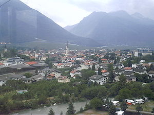
Schlanders
Comune in Trentino-Alto Adige/Südtirol, Italy
Distance: Approx. 7282 meters
Latitude and longitude: 46.63333333,10.76666667
Schlanders (German pronunciation: [ˈʃlandɐs]; Italian: Silandro [siˈlandro]) is a comune (municipality) and a village in South Tyrol in northern Italy, located about 50 kilometres (31 mi) west of the city of Bolzano.

Vinschgau
District in Italy
Distance: Approx. 6087 meters
Latitude and longitude: 46.63333333,10.78333333
The Vinschgau, Vintschgau (German: [ˈfɪn(t)ʃɡaʊ]) or Vinschgau Valley (Italian: Val Venosta [ˈval veˈnɔsta]; Romansh: Vnuost [ˈfnuɔ̯ʃt] ; Ladin: Val Venuesta; medieval toponym: Finsgowe) is the upper part of the Adige or Etsch river valley, in the western part of the province of South Tyrol, Italy.
Kastelbell-Tschars
Comune in Trentino-Alto Adige/Südtirol, Italy
Distance: Approx. 4017 meters
Latitude and longitude: 46.63333333,10.9
Kastelbell-Tschars (German: [ˌkastl̩ˈbɛl ˈtʃaːɐ̯s]; Italian: Castelbello-Ciardes [kaˌstɛlˈbɛllo ˈtʃardes]) is a comune (municipality) in South Tyrol in northern Italy, located about 40 kilometres (25 mi) northwest of Bolzano.
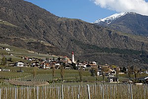
Latsch
Comune in Trentino-Alto Adige/Südtirol, Italy
Distance: Approx. 867 meters
Latitude and longitude: 46.61666667,10.86666667
Latsch (German pronunciation: [latʃ]; Italian: Laces [ˈlaːtʃes]) is a comune (municipality) and a village in the province of South Tyrol in northern Italy, located about 40 kilometres (25 mi) northwest of the city of Bolzano.

Martell, South Tyrol
Comune in Trentino-Alto Adige/Südtirol, Italy
Distance: Approx. 8963 meters
Latitude and longitude: 46.55,10.78333333
Martell (German pronunciation: [marˈtɛl]; Italian: Martello [marˈtɛllo]) is a valley and comune (municipality) in South Tyrol in northern Italy. It is located in the Martell Valley of the 28.5-kilometre (17.7 mi) long river Plima, about 45 kilometres (28 mi) west of Bolzano. The commune reaches from an elevation of 957 metres (3,140 ft) up to the 3,757 metres (12,326 ft) of the Zufallspitze (Italian: Monte Cevedale) which towers over the southeastern end of the valley.
Ulten
Comune in Trentino-Alto Adige/Südtirol, Italy
Distance: Approx. 7008 meters
Latitude and longitude: 46.55,10.86666667
Ulten (German pronunciation: [ˈʊltn̩]; Italian: Ultimo [ˈultimo]) is a comune (municipality) in South Tyrol in northern Italy, located about 35 kilometres (22 mi) west of Bolzano.

Plima
River in Italy
Distance: Approx. 1609 meters
Latitude and longitude: 46.61888889,10.83805556
The Plima (Italian: Rio Plima; German: Plima) is a stream in South Tyrol, Italy. It flows into the Adige near Latsch.
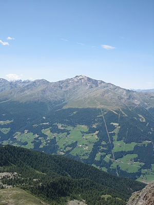
Hasenöhrl (Ortler Alps)
Mountain in Italy
Distance: Approx. 7525 meters
Latitude and longitude: 46.545,10.85777778
Hasenöhrl (3,257 m) is a mountain of the Ortler Alps in South Tyrol, Italy. The easternmost summit of the Ortlers, it is located in a triangle between the valleys of Val Martello, Ulten Valley and Vinschgau. It is a popular peak to climb due to its relative ease and far reaching views which include the Ötztal Alps, the Adamello-Presanella Alps and the Dolomites.

Mastaunspitze
Mountain in Italy
Distance: Approx. 9933 meters
Latitude and longitude: 46.69361111,10.8025
The Mastaunspitze (Italian: Punta di Mastàun) is a mountain in the Saldurkamm group of the Ötztal Alps.

Morter
Distance: Approx. 3389 meters
Latitude and longitude: 46.6,10.81666667
Morter is a subdivision of the municipality of Latsch in South Tyrol, Italy.
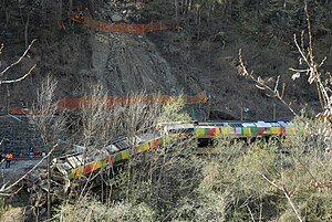
Merano derailment
2010 railway accident in Italy
Distance: Approx. 1922 meters
Latitude and longitude: 46.62384444,10.87607778
The Merano derailment occurred on 12 April 2010 when a train derailed between Latsch and Kastelbell, near Merano, Italy, after running into a landslide, causing nine deaths and injuring 28 people.

Juval Castle
Distance: Approx. 9533 meters
Latitude and longitude: 46.6515,10.9681
Juval Castle (German: Schloss Juval; Italian: Castel Juval [kaˈstɛl juˈval]) is a medieval castle located at the entrance of the Schnalstal, in the Vinschgau, above the village of Naturns in the comune of Kastelbell-Tschars at around 1000 meters above sea level, in South Tyrol, northern Italy. It derives its name from the Latin name of the mountain, Mons Jovis (mountain of Jupiter). The oldest account of the castle dates to 1278, when it was owned by Hugo of Montalban.
Weather in this IP's area
broken clouds
19 Celsius
19 Celsius
17 Celsius
20 Celsius
1017 hPa
64 %
1017 hPa
943 hPa
10000 meters
2.26 m/s
2.27 m/s
142 degree
63 %
06:59:53
19:20:47