185.231.220.110 - IP Lookup: Free IP Address Lookup, Postal Code Lookup, IP Location Lookup, IP ASN, Public IP
Country:
Region:
City:
Location:
Time Zone:
Postal Code:
IP information under different IP Channel
ip-api
Country
Region
City
ASN
Time Zone
ISP
Blacklist
Proxy
Latitude
Longitude
Postal
Route
Luminati
Country
ASN
Time Zone
Europe/Amsterdam
ISP
WIIT AG
Latitude
Longitude
Postal
IPinfo
Country
Region
City
ASN
Time Zone
ISP
Blacklist
Proxy
Latitude
Longitude
Postal
Route
IP2Location
185.231.220.110Country
Region
gelderland
City
doesburg
Time Zone
Europe/Amsterdam
ISP
Language
User-Agent
Latitude
Longitude
Postal
db-ip
Country
Region
City
ASN
Time Zone
ISP
Blacklist
Proxy
Latitude
Longitude
Postal
Route
ipdata
Country
Region
City
ASN
Time Zone
ISP
Blacklist
Proxy
Latitude
Longitude
Postal
Route
Popular places and events near this IP address

Angerlo
Village in Gelderland, Netherlands
Distance: Approx. 1893 meters
Latitude and longitude: 51.9956,6.1358
Angerlo is a village in the municipality of Zevenaar, in the eastern Netherlands. It is located about 2 km south of Doesburg. Until 1 January 2005, Angerlo was an independent municipality, with a population of about 5,000.

Doesburg
Municipality in Gelderland, Netherlands
Distance: Approx. 600 meters
Latitude and longitude: 52.01666667,6.13333333
Doesburg (Dutch pronunciation: [ˈduzbʏr(ə)x] ) is a municipality and a city in the eastern Netherlands in the province of Gelderland. Doesburg received city rights in 1237 and had a population of 11,064 in 2021. The city is situated on the right bank of the River IJssel at its confluence with the River Oude IJssel.

Dieren
Town in Gelderland, Netherlands
Distance: Approx. 5004 meters
Latitude and longitude: 52.05,6.09861111
Dieren (Dutch pronunciation: [ˈdiːrə(n)]) is a town in the eastern Netherlands. It is located in Rheden, Gelderland, between Zutphen and Arnhem, on the bank of the IJssel. Dieren was a separate municipality until 1818, when it became a part of Rheden.

Oude IJssel
River in Germany and the Netherlands
Distance: Approx. 745 meters
Latitude and longitude: 52.01275,6.12802778
The Oude IJssel (Dutch, pronounced [ˌʌudə ˈʔɛisəl], literally old IJssel) or Issel (German, pronounced [ˈɪsl̩]) is a river in Germany and the Netherlands approximately 82 km (51 mi) long. It is a right tributary of the river IJssel. Oude IJssel is Dutch for "Old IJssel"; the Oude IJssel was the upper course of the IJssel until the connection with the Rhine was dug, possibly in the Roman era.
Keppel, Netherlands
Former municipality in Gelderland
Distance: Approx. 5131 meters
Latitude and longitude: 52.0025,6.212
Keppel is a former municipality in the Dutch province of Gelderland, consisting of the villages of Laag-Keppel and Hoog-Keppel. It existed until 1818, when it merged with Hummelo to form the new municipality of Hummelo en Keppel.
Dieren railway station
Railway station located in Dieren, Netherlands
Distance: Approx. 4362 meters
Latitude and longitude: 52.045,6.10333333
Dieren is a railway station located in Dieren, Netherlands. The station was opened on 2 February 1865 and is located on the Arnhem–Leeuwarden railway. Until 1976, the official name was Dieren-Doesburg.

Martinikerk (Doesburg)
Church in Doesburg, Netherlands
Distance: Approx. 417 meters
Latitude and longitude: 52.0145,6.13375
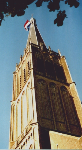
The Martinikerk (also Sint Martinuskerk or Hervormde kerk) is a church in Doesburg, Netherlands. The church's tower is the eighth tallest in the Netherlands at 94 metres (308 ft).

Middachten Castle
Dutch castle
Distance: Approx. 4797 meters
Latitude and longitude: 52.019167,6.069722
Middachten Castle (Dutch: Kasteel Middachten) is a monumental manor house, located on the Middachten estate, De Steeg, Netherlands. The current building dates from 1693-1698. The castle is a rijksmonument since October 11, 2004, and is part of the Top 100 Dutch heritage sites.

De Steeg
Village in Gelderland, Netherlands
Distance: Approx. 4971 meters
Latitude and longitude: 52.01666667,6.06666667
De Steeg is a Dutch village within the municipality of Rheden. Due to its central location within the municipality, it houses the town hall. Middachten Castle is located near the village.

Ellecom
Village in Gelderland, Netherlands
Distance: Approx. 4457 meters
Latitude and longitude: 52.03333333,6.08333333
Ellecom is a village in the municipality of Rheden in the province of Gelderland, the Netherlands.

Rha, Netherlands
Hamlet in Gelderland, Netherlands
Distance: Approx. 4633 meters
Latitude and longitude: 52.053901,6.145838
Rha is a hamlet in the municipality of Bronckhorst, Gelderland, the Netherlands. Its population is about 75 and Rha and nearby Olburgen celebrated their 1000-year existence in 1996. Windmill De Hoop is located in Rha as well as the Bronckhorster Brewing Company.

Drempt
Village in Gelderland, Netherlands
Distance: Approx. 2253 meters
Latitude and longitude: 52.0076,6.1708
Drempt is a village in the Dutch province of Gelderland. It is located in the municipality of Bronckhorst. It used to consists of two villages: Achter-Drempt (behind) and Voor-Drempt (in front) which have merged.
Weather in this IP's area
heavy intensity drizzle rain
3 Celsius
1 Celsius
3 Celsius
4 Celsius
1025 hPa
94 %
1025 hPa
1023 hPa
6000 meters
2.57 m/s
190 degree
75 %
