Country:
Region:
City:
Latitude and Longitude:
Time Zone:
Postal Code:
IP information under different IP Channel
ip-api
Country
Region
City
ASN
Time Zone
ISP
Blacklist
Proxy
Latitude
Longitude
Postal
Route
Luminati
Country
Region
zh
City
delft
ASN
Time Zone
Europe/Amsterdam
ISP
Emenders BV
Latitude
Longitude
Postal
IPinfo
Country
Region
City
ASN
Time Zone
ISP
Blacklist
Proxy
Latitude
Longitude
Postal
Route
db-ip
Country
Region
City
ASN
Time Zone
ISP
Blacklist
Proxy
Latitude
Longitude
Postal
Route
ipdata
Country
Region
City
ASN
Time Zone
ISP
Blacklist
Proxy
Latitude
Longitude
Postal
Route
Popular places and events near this IP address

Museum Het Prinsenhof
Former monastery and municipal museum in Delft, Netherlands
Distance: Approx. 705 meters
Latitude and longitude: 52.012,4.354
Het Prinsenhof ("The Court of the Prince") is a museum in the city of Delft in the Netherlands. Formerly the monastery of St Agatha, the building changed purpose over time. The whole building came into the possession of Delft City Council by 1925, who gradually converted the building into a museum.

IHE Delft Institute for Water Education
Distance: Approx. 843 meters
Latitude and longitude: 52.00861111,4.35694444
IHE Delft Institute for Water Education is the largest international graduate water education facility in the world and is based in Delft, Netherlands. Delft is a world renowned knowledge centre on water infrastructure, technology and sciences, and attracts high-level students and scientists from around the globe. IHE Delft cooperates with Delft, the water knowledge city, and water related institutes based in Delft.

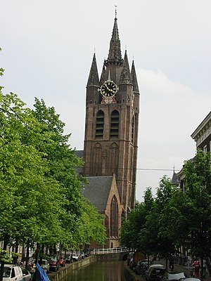
Oude Kerk (Delft)
Distance: Approx. 808 meters
Latitude and longitude: 52.0125,4.35527778
The Oude Kerk (Old Church), nicknamed Oude Jan ("Old John") and Scheve Jan ("Skewed John"), is a Gothic Protestant church in the old city center of Delft, the Netherlands. Its most recognizable feature is a 75-meter-high brick tower that leans about two meters from the vertical.

Hof van Delft
Distance: Approx. 315 meters
Latitude and longitude: 52.01166667,4.34722222
Hof van Delft ("Court of Delft") is a former municipality in the Dutch province of South Holland. It was located to the west of the city of Delft, and covered the villages of Den Hoorn, Abtswoude, and 't Woudt. The municipality existed from 1817 to 1921, when it became a part of Delft.

Delft railway station
Railway station in Delft, Netherlands
Distance: Approx. 871 meters
Latitude and longitude: 52.00666667,4.35666667
Delft is the main railway station of the city of Delft, South Holland, Netherlands. It is located on the oldest railway line in the country, between the stations of The Hague Central and Rotterdam Central. Along with a new 2.3 km rail tunnel under the city centre, the current station opened on 28 February 2015.

Hoogheemraadschap van Delfland
Place in Netherlands
Distance: Approx. 797 meters
Latitude and longitude: 52.0118,4.3556
The Hoogheemraadschap van Delfland is a Dutch waterboard, which is responsible for water management. It covers the municipalities of Delft, Midden-Delfland and The Hague, and is fully located in the province of South Holland. The organization was established in 1289 when William I, Duke of Bavaria (As William V, Count of Holland) authorized the "Heemraden of Delft" to manage water and serve as a court.

Le Chevalier (restaurant)
Restaurant in Delft, Netherlands
Distance: Approx. 819 meters
Latitude and longitude: 52.0107,4.35643056
Le Chevalier is a defunct restaurant in Delft, Netherlands. It was a fine dining restaurant that was awarded one Michelin star in the periods 1980–1989. Cees Helder, was head chef from 1980 to 1984.

Agnetapark
Area of workers' housing in South Holland
Distance: Approx. 762 meters
Latitude and longitude: 52.01611111,4.34583333
Agnetapark was an area of workers' housing in Delft, South Holland, the Netherlands. It was one of the highest quality workers' housing areas built before the Housing Act of 1902 was imposed. It was 'transformed' from a marshy 4 hectares (9.9 acres) area of land to a 'paradise' of industry.

St Stanislas College, Delft
Private secondary school in Delft, Pijnacker, and Rijswijk, South Holland, Netherlands
Distance: Approx. 94 meters
Latitude and longitude: 52.008575,4.345414
St Stanislas College (Dutch: Stanislascollege) is a conglomerate of private Catholic secondary schools located in Delft, Pijnacker, and Rijswijk, in the province of South Holland, in the Netherlands. Saint Stanislas College itself was founded in Delft as a Gymnasium in 1948 by the Society of Jesus. When other surrounding schools needed to work together to secure funding they joined to form a conglomerate.

Flower-holder
Distance: Approx. 716 meters
Latitude and longitude: 52.0117,4.3544
The Flower-holder (Tulpenvaas) is one of a matching pair of tulip vases dated to ca. 1690 and currently in the collection of Museum Het Prinsenhof. The pair was created in the tin-glazed delftware company called "De Griekse A" ("The Greek A") in Delft.

Saint Hippolytus Chapel, Delft
Distance: Approx. 843 meters
Latitude and longitude: 52.011209,4.356608
The Saint Hippolytus Chapel (Dutch: Sint-Hippolytuskapel) is a chapel in the old city of Delft. It is one of the oldest buildings in Delft, and since 1967 it has been designated the Rijksmonument. The church was built around 1400 in the Gothic style and is located on the east side of the Oude Deft.

De Roos
Mill from Delft, South Holland, Netherlands.
Distance: Approx. 686 meters
Latitude and longitude: 52.01388889,4.35138889
De Roos (literally, "The Rose"), also locally known as Roosmolen or Koren op de Molen, is a wind and platform mill situated within the municipality of Delft, in the South Holland province of the Netherlands. The mill was originally constructed on the southern city wall of Delft but was later relocated and rebuilt above the western fortifications of the Dutch municipality in 1679. Two principal phases of implementation of the Delft mill followed this reconstruction.
Weather in this IP's area
mist
8 Celsius
8 Celsius
7 Celsius
9 Celsius
1027 hPa
95 %
1027 hPa
1027 hPa
3500 meters
0.89 m/s
0.89 m/s
224 degree
100 %
07:47:01
17:05:31