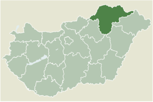
Country:
 Hungary
Region:
City:
Latitude and Longitude:
Time Zone:
Postal Code:
IP information under different IP Channel
ip-api
Country
Region
City
ASN
Time Zone
ISP
Blacklist
Proxy
Latitude
Longitude
Postal
Route
IPinfo
Country
Region
City
ASN
Time Zone
ISP
Blacklist
Proxy
Latitude
Longitude
Postal
Route
MaxMind
Country
Region
City
ASN
Time Zone
ISP
Blacklist
Proxy
Latitude
Longitude
Postal
Route
Luminati
Country
HURegion
bz
City
tiszaluc
ASN
Time Zone
Europe/Budapest
ISP
Microsystem-Kecskemet Kft
Latitude
Longitude
Postal
db-ip
Country
Region
City
ASN
Time Zone
ISP
Blacklist
Proxy
Latitude
Longitude
Postal
Route
ipdata
Country
Region
City
ASN
Time Zone
ISP
Blacklist
Proxy
Latitude
Longitude
Postal
Route
Popular places and events near this IP address

Hornád
River in Slovakia and Hungary
Distance: Approx. 1496 meters
Latitude and longitude: 47.9903,20.9296
The Hornád (Slovak, pronounced [ˈɦɔrnaːt]) or Hernád (Hungarian, pronounced [ˈhɛrnaːd]) is a river in eastern Slovakia and north-eastern Hungary. It is a tributary to the river Slaná (Sajo). The source of the Hornád is the eastern slopes of Kráľova hoľa hill, south of Šuňava.

Battle of Mohi
1241 battle during the first Mongol invasion of Hungary
Distance: Approx. 2458 meters
Latitude and longitude: 47.97777778,20.91305556
The Battle of Mohi (11 April 1241), also known as Battle of the Sajó River or Battle of the Tisza River, was the main battle between the Mongol Empire and the Kingdom of Hungary during the Mongol invasion of Europe. It took place at Muhi (then Mohi), southwest of the Sajó River. The battle resulted in a pyrrhic victory for the Mongols, who destroyed the Hungarian Royal army, at a heavy cost which contributed to the decision to halt the campaign.

Muhi
Place in Borsod-Abaúj-Zemplén, Hungary
Distance: Approx. 2651 meters
Latitude and longitude: 47.97789,20.92933
Muhi is a village in Borsod-Abaúj-Zemplén County, Hungary. The area has been inhabited since prehistoric times. In the thirteenth century, two villages stood here.
Berzék
Place in Borsod-Abaúj-Zemplén, Hungary
Distance: Approx. 3920 meters
Latitude and longitude: 48.02439,20.95307
Berzék is a village in Borsod-Abaúj-Zemplén county, Hungary.
Hejőkeresztúr
Place in Borsod-Abaúj-Zemplén, Hungary
Distance: Approx. 4986 meters
Latitude and longitude: 47.96325,20.87672
Hejőkeresztúr is a village in Borsod-Abaúj-Zemplén county, Hungary.
Köröm
Village in Northern Hungary, Hungary
Distance: Approx. 3163 meters
Latitude and longitude: 47.98333333,20.95
Köröm is a village in Borsod-Abaúj-Zemplén County in northeastern Hungary.
Nagycsécs
Village in Northern Hungary, Hungary
Distance: Approx. 4500 meters
Latitude and longitude: 47.96666667,20.95
Nagycsécs is a village in Borsod-Abaúj-Zemplén County in northeastern Hungary.
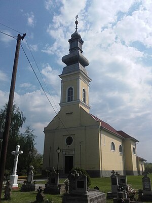
Ónod
Village in Northern Hungary, Hungary
Distance: Approx. 97 meters
Latitude and longitude: 48,20.91666667
Ónod is a village in Borsod-Abaúj-Zemplén County in northeastern Hungary. There are around 2,000 people living there. Ónod has a long history reflected by some of the older buildings in the town, including the castle and the post carriage stopping point.
Sajópetri
Village in Northern Hungary, Hungary
Distance: Approx. 3905 meters
Latitude and longitude: 48.03333333,20.9
Sajópetri is a village in Borsod-Abaúj-Zemplén County in northeastern Hungary.

Sajólád
Village in Northern Hungary, Hungary
Distance: Approx. 4961 meters
Latitude and longitude: 48.04358,20.90297
Sajólád is a village in Borsod-Abaúj-Zemplén County in northeastern Hungary.
Szakáld
Village in Northern Hungary, Hungary
Distance: Approx. 5545 meters
Latitude and longitude: 47.95,20.91666667
Szakáld is a village in Borsod-Abaúj-Zemplén County in northeastern Hungary.

Sajóhídvég
Village in Northern Hungary, Hungary
Distance: Approx. 2660 meters
Latitude and longitude: 48.0042,20.9505
Sajóhídvég is a village in Borsod-Abaúj-Zemplén County in north-eastern Hungary.
Weather in this IP's area
broken clouds
19 Celsius
18 Celsius
19 Celsius
19 Celsius
1021 hPa
63 %
1021 hPa
1009 hPa
10000 meters
3.57 m/s
7.51 m/s
59 degree
55 %
06:19:12
18:41:01