185.221.127.50 - IP Lookup: Free IP Address Lookup, Postal Code Lookup, IP Location Lookup, IP ASN, Public IP
Country:
Region:
City:
Location:
Time Zone:
Postal Code:
IP information under different IP Channel
ip-api
Country
Region
City
ASN
Time Zone
ISP
Blacklist
Proxy
Latitude
Longitude
Postal
Route
Luminati
Country
Region
80
City
jablunkov
ASN
Time Zone
Europe/Prague
ISP
HoralNET s.r.o.
Latitude
Longitude
Postal
IPinfo
Country
Region
City
ASN
Time Zone
ISP
Blacklist
Proxy
Latitude
Longitude
Postal
Route
IP2Location
185.221.127.50Country
Region
moravskoslezsky kraj
City
jablunkov
Time Zone
Europe/Prague
ISP
Language
User-Agent
Latitude
Longitude
Postal
db-ip
Country
Region
City
ASN
Time Zone
ISP
Blacklist
Proxy
Latitude
Longitude
Postal
Route
ipdata
Country
Region
City
ASN
Time Zone
ISP
Blacklist
Proxy
Latitude
Longitude
Postal
Route
Popular places and events near this IP address
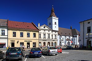
Jablunkov
Town in Moravian-Silesian, Czech Republic
Distance: Approx. 10 meters
Latitude and longitude: 49.57666667,18.76472222
Jablunkov (Czech pronunciation: [ˈjabluŋkof] ; Polish: , German: Jablunkau) is a town in Frýdek-Místek District in the Moravian-Silesian Region of the Czech Republic. It has about 5,300 inhabitants. The town has a significant Polish minority.

Návsí
Municipality in Moravian-Silesian, Czech Republic
Distance: Approx. 1235 meters
Latitude and longitude: 49.58722222,18.75916667
Návsí (Polish: , German: Nawsi) is a municipality and village in Frýdek-Místek District in the Moravian-Silesian Region of the Czech Republic. It has about 3,900 inhabitants. The municipality has a significant Polish minority.

Písek (Frýdek-Místek District)
Municipality in Moravian-Silesian, Czech Republic
Distance: Approx. 3345 meters
Latitude and longitude: 49.55916667,18.80222222
Písek (Polish: , German: Piosek) is a municipality and village in Frýdek-Místek District in the Moravian-Silesian Region of the Czech Republic. It has about 1,900 inhabitants. The municipality has a significant Polish minority.

Bukovec (Frýdek-Místek District)
Municipality in Moravian-Silesian, Czech Republic
Distance: Approx. 5327 meters
Latitude and longitude: 49.55111111,18.82694444
Bukovec (Czech pronunciation: [ˈbukovɛts] ; Polish: Bukowiec, German: Bukowetz) is a municipality and village in Frýdek-Místek District in the Moravian-Silesian Region of the Czech Republic. It has about 1,400 inhabitants. The municipality has a significant Polish minority.

Milíkov (Frýdek-Místek District)
Municipality in Moravian-Silesian, Czech Republic
Distance: Approx. 3405 meters
Latitude and longitude: 49.58555556,18.71944444
Milíkov (Polish: ) is a municipality and village in Frýdek-Místek District in the Moravian-Silesian Region of the Czech Republic. It has about 1,300 inhabitants. The municipality has a significant Polish minority.
Písečná (Frýdek-Místek District)
Municipality in Moravian-Silesian, Czech Republic
Distance: Approx. 1668 meters
Latitude and longitude: 49.57472222,18.7875
Písečná (Czech: [ˈpiːsɛtʃnaː] ; Polish: Pioseczna [pjɔˈsɛt͡ʂna] ) is a municipality and village in Frýdek-Místek District in the Moravian-Silesian Region of the Czech Republic. It has about 1,100 inhabitants. The municipality has a significant Polish minority.

Hrádek (Frýdek-Místek District)
Municipality in Moravian-Silesian, Czech Republic
Distance: Approx. 4868 meters
Latitude and longitude: 49.61666667,18.73722222
Hrádek (Czech pronunciation: [ˈɦraːdɛk]; Polish: , German: Grudek) is a municipality and village in Frýdek-Místek District in the Moravian-Silesian Region of the Czech Republic. It has about 1,900 inhabitants. The municipality has a significant Polish minority.

Bocanovice
Municipality in Moravian-Silesian, Czech Republic
Distance: Approx. 2073 meters
Latitude and longitude: 49.56916667,18.73833333
Bocanovice (Polish: ) is a municipality and village in Frýdek-Místek District in the Moravian-Silesian Region of the Czech Republic. It has about 500 inhabitants. The municipality has a significant Polish minority.

Dolní Lomná
Municipality in Moravian-Silesian, Czech Republic
Distance: Approx. 5310 meters
Latitude and longitude: 49.54777778,18.70611111
Dolní Lomná (Polish: , German: Nieder Lomna) is a municipality and village in Frýdek-Místek District in the Moravian-Silesian Region of the Czech Republic. It has about 900 inhabitants. The municipality has a significant Polish minority.

Stożek Wielki
Mountain in Poland and the Czech Republic
Distance: Approx. 5302 meters
Latitude and longitude: 49.605556,18.823056
Stożek Wielki (Czech: Velký Stožek; literally "big cone") is a mountain in the Silesian Beskids mountain range on the border of Poland and the Czech Republic . It reaches a height of 978 metres (3,209 ft). The peak of the mountain has a characteristic conical shape and on its slopes grow beech and coniferous trees.
Lomná (river)
River in Moravian-Silesian, Czech Republic
Distance: Approx. 276 meters
Latitude and longitude: 49.57916667,18.76416667
The Lomná (Polish: Łomna) is a river in the Czech Republic, a left tributary of the Olza. It flows through the Moravian-Silesian Region. It is 17.6 km (10.9 mi) long.

Košařiska
Municipality in Moravian-Silesian, Czech Republic
Distance: Approx. 5256 meters
Latitude and longitude: 49.59,18.69472222
Košařiska (Polish: ) is a municipality and village in Frýdek-Místek District in the Moravian-Silesian Region of the Czech Republic. It has about 400 inhabitants. The municipality has a significant Polish minority.
Weather in this IP's area
clear sky
6 Celsius
5 Celsius
1 Celsius
7 Celsius
1029 hPa
100 %
1029 hPa
981 hPa
10000 meters
1.66 m/s
2.86 m/s
205 degree
5 %


