185.220.115.50 - IP Lookup: Free IP Address Lookup, Postal Code Lookup, IP Location Lookup, IP ASN, Public IP
Country:
Region:
City:
Location:
Time Zone:
Postal Code:
IP information under different IP Channel
ip-api
Country
Region
City
ASN
Time Zone
ISP
Blacklist
Proxy
Latitude
Longitude
Postal
Route
Luminati
Country
ASN
Time Zone
Asia/Baghdad
ISP
Zana Mohammed Mahdi A.Rahman company for Internet Service Provider LTD
Latitude
Longitude
Postal
IPinfo
Country
Region
City
ASN
Time Zone
ISP
Blacklist
Proxy
Latitude
Longitude
Postal
Route
IP2Location
185.220.115.50Country
Region
ninawa
City
qada' al hamdaniyah
Time Zone
Asia/Baghdad
ISP
Language
User-Agent
Latitude
Longitude
Postal
db-ip
Country
Region
City
ASN
Time Zone
ISP
Blacklist
Proxy
Latitude
Longitude
Postal
Route
ipdata
Country
Region
City
ASN
Time Zone
ISP
Blacklist
Proxy
Latitude
Longitude
Postal
Route
Popular places and events near this IP address
Karamlesh
Town in Nineveh, Iraq
Distance: Approx. 5007 meters
Latitude and longitude: 36.30361111,43.41277778
Karamlesh (Syriac: ܟܪܡܠܫ, Arabic: كرمليس; also spelled Karemlash, Karemles, Karemlish, etc.) is a town in northern Iraq located less than 18 miles (29 km) south east of Mosul. It is surrounded by many hills that along with it made up the historical Assyrian city of Kar-Mullissi (written URU.kar-dNIN.LÍL), which means "the city of Mullissu" in Akkadian. Its Assyrian residents fled to Kurdistan Region because of the planned escape from the peshmerga following the invasion of the town by ISIS in August 2014.
Bartella
Town in Ninawa, Iraq
Distance: Approx. 9002 meters
Latitude and longitude: 36.35222222,43.37972222
Bartella (Syriac: ܒܪܛܠܐ; Arabic: برطلّة) is a town that is located in the Nineveh Plains in northern Iraq, about 21 kilometres (13 miles) east of Mosul. Bartella was liberated from ISIL control on October 20, 2016 by Iraqi Special Operations Forces along with the Nineveh Plain Protection Units and PMF Brigade 30, who both currently control and run the city's security. The town is populated by Assyrian Christians and Shabaks.
Qaraqosh
Town in Nineveh, Iraq
Distance: Approx. 394 meters
Latitude and longitude: 36.26972222,43.3775
Qaraqosh (Syriac: ܩܪܩܘ݂ܫ, romanized: Qaraqoš; Arabic: بغديدا, romanized: Baḡdīda (official name), or Arabic: بخديدا, romanized: Baḵdīda, also known as al-Ḥamdāniyya or Qara-Qūš; a Turkic placename meaning "Black Bird"), is an Assyrian city in the Nineveh Governorate, of Iraq located about 32 kilometres (20 mi) southeast of the city of Mosul and 60 kilometres (37 mi) west of Erbil amid agricultural lands, close to the ruins of the ancient Assyrian cities Kalhu and Nineveh. Qaraqosh is connected to the main city of Mosul by two main roads. The first runs through the Assyrian towns of Bartella and Karamlesh, which connects to the city of Erbil as well.
Balawat
Assyrian archaeological site in Iraq
Distance: Approx. 5385 meters
Latitude and longitude: 36.22944444,43.40333333
Balawat (Classical Syriac: ܒܝܬ ܠܒܬ, beṯ labat) is an archaeological site of the ancient Assyrian city of Imgur-Enlil, and modern village in Nineveh Province (Iraq). It lies 25 kilometres (16 mi) southeast from the city of Mosul and 4 kilometres (2.5 mi) to the south of the modern Assyrian town of Bakhdida.

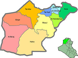
Al-Hamdaniya District
District in Iraq
Distance: Approx. 11 meters
Latitude and longitude: 36.2714,43.3737
Al-Hamdaniya District (also known as Bakhdida District; Arabic: قضاء الحمدانية; Syriac: ܪܘܼܣܬܩܐ ܕ ܒܓ݂ܕܝܕܐ) is a district in the north-east of the Nineveh Governorate (Ninawa) of Iraq. Al-Hamdaniya District is divided between four sub-districts: Aski Kalak (Khabat) Sub-District, mostly Kurdish, some Assyrians and Yazidis, (de facto or even unofficial part of Aqrah district). al-Namrud (al-Khidhr) Sub-District, mostly Arab and Turkmen, some Kaka'is, Shabak and Assyrian, Bartillah (Baritleh) Sub-District, mostly Assyrian, some Shabak, Arab and Turkmen, Qaraqosh (Bakhdida) Sub-District, mostly Assyrians, some Arabs, Shabak, Turkmen and Kaka'is.

Monastery of Saint John of Dailam
Syriac Orthodox Monastery in Iraq
Distance: Approx. 3142 meters
Latitude and longitude: 36.29972222,43.37333333
The Monastery of Saint John of Dailam, also known as Naqortaya and Muqurtaya (Syriac: ܕܝܪܐ ܢܩܘܪܬܝܐ, romanized: dayrā naqortāyā, lit. 'chiseled monastery'), is a Syriac Orthodox monastery that lies 3 km north of Qaraqosh in northern Iraq.
Qaraqosh wedding fire
2023 blaze in Hamdaniya, Iraq
Distance: Approx. 1102 meters
Latitude and longitude: 36.28083333,43.37777778
On 26 September 2023, at around 22:45 AST, a fire broke out at the Al Haytham Wedding Hall during an Assyrian wedding in Qaraqosh, Al-Hamdaniya District, Nineveh Governorate, Iraq. The fireworks accident was triggered by the ignition of ceiling by pyrotechnic flares. Out of the estimated 1,000 people present, approximately 107 were killed, and 82 were injured.
Weather in this IP's area
overcast clouds
14 Celsius
13 Celsius
14 Celsius
14 Celsius
1017 hPa
53 %
1017 hPa
987 hPa
10000 meters
1.36 m/s
1.42 m/s
333 degree
100 %


