185.220.112.3 - IP Lookup: Free IP Address Lookup, Postal Code Lookup, IP Location Lookup, IP ASN, Public IP
Country:
Region:
City:
Location:
Time Zone:
Postal Code:
ISP:
ASN:
language:
User-Agent:
Proxy IP:
Blacklist:
IP information under different IP Channel
ip-api
Country
Region
City
ASN
Time Zone
ISP
Blacklist
Proxy
Latitude
Longitude
Postal
Route
db-ip
Country
Region
City
ASN
Time Zone
ISP
Blacklist
Proxy
Latitude
Longitude
Postal
Route
IPinfo
Country
Region
City
ASN
Time Zone
ISP
Blacklist
Proxy
Latitude
Longitude
Postal
Route
IP2Location
185.220.112.3Country
Region
as sulaymaniyah
City
chamchamal
Time Zone
Asia/Baghdad
ISP
Language
User-Agent
Latitude
Longitude
Postal
ipdata
Country
Region
City
ASN
Time Zone
ISP
Blacklist
Proxy
Latitude
Longitude
Postal
Route
Popular places and events near this IP address

Jarmo
Archeological site in northern Iraq
Distance: Approx. 9184 meters
Latitude and longitude: 35.55583333,44.93027778
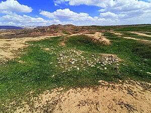
Jarmo (Kurdish: چەرمۆ, romanized: Çermo or Qelay Çermo, also Qal'at Jarmo) is a prehistoric archeological site located in modern Iraqi Kurdistan on the foothills of the Zagros Mountains. It lies at an altitude of 800 m above sea-level in a belt of oak and pistachio woodlands in the Adhaim River watershed. Excavations revealed that Jarmo was an agricultural community dating back to 7090 BC. It was broadly contemporary with other important Neolithic sites such as Jericho in the Southern Levant and Çatalhöyük in Anatolia.

Chamchamal
Town in Kurdistan Region, Iraq
Distance: Approx. 382 meters
Latitude and longitude: 35.53333333,44.83333333
Chamchamal (Kurdish: چهمچهماڵ, romanized: Çemçemal, Arabic: جمجمال) is a town located in Sulaymaniyah Governorate, Kurdistan Region, Iraq. it is the town which is nearest located to the disputed territories of Northern Iraq. Chamchamal is home to the Gorani-speaking Hamawand tribe.
Girdi Qala and Logardan
Archaeological site in Iraq
Distance: Approx. 5209 meters
Latitude and longitude: 35.51638889,44.88361111
Girdi Qala and Logardan (a few hundred meters to the north) are adjacent ancient Near East archaeological sites in Sulaymānīyah Governorate in northeast Iraq in the Kurdistan region, parts of a complex that was occupied off and on for at least six millennia. The site lies on the west bank of the Tavuq Cay river, a tributary of the Tigris river. The nearest notable archaeological sites are Jarmo to the north and Tell Kunara to the east.
Weather in this IP's area
few clouds
7 Celsius
6 Celsius
7 Celsius
7 Celsius
1023 hPa
62 %
1023 hPa
933 hPa
10000 meters
2.07 m/s
2.03 m/s
345 degree
14 %