Country:
 Great Britain
Region:
City:
Latitude and Longitude:
Time Zone:
Postal Code:
IP information under different IP Channel
ip-api
Country
Region
City
ASN
Time Zone
ISP
Blacklist
Proxy
Latitude
Longitude
Postal
Route
IPinfo
Country
Region
City
ASN
Time Zone
ISP
Blacklist
Proxy
Latitude
Longitude
Postal
Route
MaxMind
Country
Region
City
ASN
Time Zone
ISP
Blacklist
Proxy
Latitude
Longitude
Postal
Route
Luminati
Country
GBRegion
eng
City
norwich
ASN
Time Zone
Europe/London
ISP
MLL Telecom Ltd.
Latitude
Longitude
Postal
db-ip
Country
Region
City
ASN
Time Zone
ISP
Blacklist
Proxy
Latitude
Longitude
Postal
Route
ipdata
Country
Region
City
ASN
Time Zone
ISP
Blacklist
Proxy
Latitude
Longitude
Postal
Route
Popular places and events near this IP address
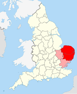
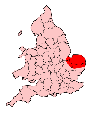
East Anglia
Region of England
Distance: Approx. 2413 meters
Latitude and longitude: 52.5,1
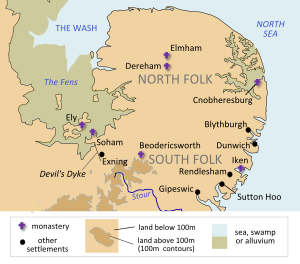
East Anglia is an area in the East of England, often defined as including the counties of Norfolk, Suffolk and Cambridgeshire. The name derives from the Anglo-Saxon kingdom of the East Angles, a people whose name originated in Anglia, in what is now Northern Germany.
Iceni
Roman-era British tribe
Distance: Approx. 2413 meters
Latitude and longitude: 52.5,1
The Iceni ( eye-SEEN-eye, Classical Latin: [ɪˈkeːniː]) or Eceni were an ancient tribe of eastern Britain during the Iron Age and early Roman era. Their territory included present-day Norfolk and parts of Suffolk and Cambridgeshire, and bordered the area of the Corieltauvi to the west, and the Catuvellauni and Trinovantes to the south. In the Roman period, their capital was Venta Icenorum at modern-day Caistor St Edmund.

Attleborough
Town in Norfolk, England
Distance: Approx. 331 meters
Latitude and longitude: 52.51826,1.01916
Attleborough is a market town and civil parish located on the A11 between Norwich and Thetford in Norfolk, England. The parish is in the district of Breckland and has an area of 21.9 square kilometres (8.5 sq mi). The 2001 Census recorded the town as having a population of 9,702 distributed between 4,185 households, increasing to a population of 10,482 in 4,481 households in the 2011 Census.

Besthorpe, Norfolk
Human settlement in England
Distance: Approx. 673 meters
Latitude and longitude: 52.517,1.033
Besthorpe is a village and civil parish in the Breckland district of Norfolk, England, about a mile east of Attleborough, on the A11 road. According to the 2001 census it had a population of 561, increasing to 778 at the 2011 Census. The villages name origin is uncertain but is thought to mean 'Bosi's outlying farms/settlement' or perhaps, 'bent-grass outlying farm/settlement'.
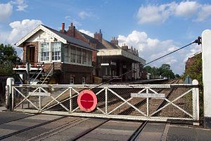
Attleborough railway station
Railway station in Norfolk, England
Distance: Approx. 279 meters
Latitude and longitude: 52.51428,1.02119
Attleborough railway station is on the Breckland line in the east of England, serving the market town of Attleborough, Norfolk. The line runs between Cambridge in the west and Norwich in the east. Attleborough is situated between Eccles Road and Spooner Row, 108 miles 19 chains (174.2 km) from London Liverpool Street via Ely.
Old Buckenham Airfield
Airport in South Norfolk
Distance: Approx. 2880 meters
Latitude and longitude: 52.4975,1.05194444
Old Buckenham Airfield (ICAO: EGSV), formerly RAF Old Buckenham, is located 12 nautical miles (22 km; 14 mi) southwest of Norwich, East Anglia, England. Old Buckenham Aerodrome has a CAA Ordinary Licence (Number P907) that allows flights for the public transport of passengers or for flying instruction as authorised by the licensee (Buckenham Aviation Centre Limited). The aerodrome is not licensed for night use.
Kingdom of East Anglia
Anglo-Saxon kingdom in southeast Britain
Distance: Approx. 2413 meters
Latitude and longitude: 52.5,1
The Kingdom of the East Angles (Old English: Ēastengla Rīċe; Latin: Regnum Orientalium Anglorum), informally known as the Kingdom of East Anglia, was a small independent kingdom of the Angles during the Anglo-Saxon period comprising what are now the English counties of Norfolk and Suffolk and perhaps the eastern part of the Fens, the area still known as East Anglia. The kingdom formed in the 6th century in the wake of the Anglo-Saxon settlement of Britain and was one of the kingdoms of the Heptarchy. It was ruled by the Wuffingas dynasty in the 7th and 8th centuries, but the territory was taken by Offa of Mercia in 794.
Morley Old Hall
Distance: Approx. 3156 meters
Latitude and longitude: 52.5445,1.0304
Morley Old Hall is a Grade I-listed moated manor house built in the sixteenth century in the village of Morley Saint Peter, some twelve miles from the cathedral city of Norwich, Norfolk, England. The house was created circa 1600 by John Sedley, an architect to Henry VII. It is built to a U-shaped floor plan in two storeys with two storeys of attics. Constructed in brick with plain-tiled roofs it is completely surrounded by a moat.

Great Ellingham Windmill
Distance: Approx. 3751 meters
Latitude and longitude: 52.53241944,0.97428333
Great Ellingham Windmill is a Grade II listed tower mill in Great Ellingham, Norfolk, England which has been converted to residential accommodation.

Old Buckenham Priory
Distance: Approx. 3353 meters
Latitude and longitude: 52.4911,1.0497
Old Buckenham Priory was an Augustinian priory built on the site of Old Buckenham Castle at Old Buckenham in Norfolk, England. The priory was founded circa 1146 by William de Albini and his wife Queen Adeliza (widow of King Henry I). The foundation charter endowed the priory with the site of the old Buckenham castle and the rectories of All Saints and St.
Attleborough Academy
Academy in Attleborough, Norfolk, England
Distance: Approx. 465 meters
Latitude and longitude: 52.5199,1.0191
Attleborough Academy/Attleborough Academy Norfolk (AA/AAN) (formerly Attleborough High School) is a coeducational secondary school and sixth form with academy status, located in Attleborough in the English county of Norfolk. Previously a community school administered by Norfolk County Council, Attleborough High School became a specialist Mathematics and Computing College in 2008. As part of this, the school became a Microsoft®Academy in 2010.

Old Buckenham Fen
Distance: Approx. 3354 meters
Latitude and longitude: 52.487,1.013
Old Buckenham Fen is a 34.5-hectare (85-acre) biological Site of Special Scientific Interest south of Attleborough in Norfolk. This valley fen has cattle grazed wet meadows, species rich reedbeds, a mere and dykes. Flora in wetter areas include ragged robin, marsh thistle and ladies smock.
Weather in this IP's area
moderate rain
13 Celsius
13 Celsius
13 Celsius
14 Celsius
1009 hPa
94 %
1009 hPa
1005 hPa
10000 meters
5.07 m/s
10.71 m/s
170 degree
100 %
07:28:52
17:52:26