185.22.255.208 - IP Lookup: Free IP Address Lookup, Postal Code Lookup, IP Location Lookup, IP ASN, Public IP
Country:
 Great Britain
Region:
City:
Location:
Time Zone:
Postal Code:
ISP:
ASN:
language:
User-Agent:
Proxy IP:
Blacklist:
IP information under different IP Channel
ip-api
Country
Region
City
ASN
Time Zone
ISP
Blacklist
Proxy
Latitude
Longitude
Postal
Route
db-ip
Country
Region
City
ASN
Time Zone
ISP
Blacklist
Proxy
Latitude
Longitude
Postal
Route
IPinfo
Country
Region
City
ASN
Time Zone
ISP
Blacklist
Proxy
Latitude
Longitude
Postal
Route
IP2Location
185.22.255.208Country
gbRegion
england
City
worthing
Time Zone
Europe/London
ISP
Language
User-Agent
Latitude
Longitude
Postal
ipdata
Country
Region
City
ASN
Time Zone
ISP
Blacklist
Proxy
Latitude
Longitude
Postal
Route
Popular places and events near this IP address
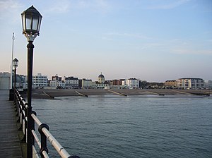
Worthing
Town and borough in West Sussex, England
Distance: Approx. 26 meters
Latitude and longitude: 50.81472222,-0.37138889
Worthing ( WUR-dhing) is a seaside town and borough in West Sussex, England, at the foot of the South Downs, 11 miles (18 km) west of Brighton, and 18 miles (29 km) east of Chichester. With a population of 113,094 and an area of 12.5 square miles (32.4 km2), the borough is the second largest component of the Brighton and Hove built-up area, the 15th most populous urban area in the United Kingdom. Northern parts of the borough, including the Worthing Downland Estate, form part of the South Downs National Park.

Worthing Museum and Art Gallery
Museum in Worthing, England
Distance: Approx. 34 meters
Latitude and longitude: 50.81457222,-0.371775
Worthing Museum and Art Gallery is in the centre of Worthing near the grade II* listed St Paul's. The building, which celebrated its centenary in 2008, was originally designed to house the town's library as well as the museum, the library section being funded by Andrew Carnegie. It is the largest museum in West Sussex.

Our Lady of Sion School
Private day school in Worthing, West Sussex, England
Distance: Approx. 441 meters
Latitude and longitude: 50.813,-0.3771
Our Lady of Sion School is an inter-denominational, independent school for male and female students, founded in 1862 and located in Worthing, West Sussex, on the south coast of England. Based on the teachings of Theodor Ratisbonne and Alphonse Ratisbonne, the school is part of a worldwide network of schools founded by the Sisters of Sion. Other Sion Schools can be found in Australia, Canada, Brazil, Costa Rica, France, Turkey, and the United States.

St Paul's Church, Worthing
Church in West Sussex, United Kingdom
Distance: Approx. 89 meters
Latitude and longitude: 50.8137,-0.3713
The Venue (formerly St Paul's Church) in Worthing, England hosts live music events. It was opened in 1812 as the Worthing Chapel of Ease. It was built so that the residents and visitors to the newly created town of Worthing would not need to travel to the parish church of St Mary in Broadwater.
Christ Church, Worthing
Church in West Sussex, United Kingdom
Distance: Approx. 268 meters
Latitude and longitude: 50.81258,-0.37359
Christ Church and its burial grounds in Worthing, England, were consecrated in 1843 by the Bishop of Chichester, Ashurst Turner Gilbert, to meet the need for church accommodation for the poor. Built by subscription between 1840 and 1843, the Church was initially regarded as a chapel of ease to St Mary's Church in Broadwater. The chapel of ease was upgraded to the status of church with its own parish in 1855.

St Mary of the Angels, Worthing
Roman Catholic church in West Sussex, England
Distance: Approx. 446 meters
Latitude and longitude: 50.8132,-0.3773
The Church of St Mary of the Angels, Worthing, is in Worthing, West Sussex, England. It is a Grade II listed building and the earliest of the four Roman Catholic churches in Worthing. It is an active Roman Catholic parish church in the diocese of Arundel & Brighton and the Worthing deanery.
Teville Stream
River in England
Distance: Approx. 432 meters
Latitude and longitude: 50.817,-0.376
The Teville Stream is a stream which flows through the town of Worthing in West Sussex. Once significantly wider than the current stream, it is now culverted for much of its length.

Worthing Tabernacle
Church in West Sussex , United Kingdom
Distance: Approx. 34 meters
Latitude and longitude: 50.8148,-0.3712
Worthing Tabernacle is an independent Evangelical Christian church in the town and borough of Worthing, one of seven local government districts in the English county of West Sussex. The present building, with its distinctive pale stone exterior and large rose window, dates from 1908, but the church was founded in 1895 in a chapel built much earlier in the 19th century during a period when the new seaside resort's population was growing rapidly. In its present form, the church is affiliated with the Fellowship of Independent Evangelical Churches.

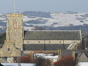
St Andrew the Apostle Church, Worthing
Church in West Sussex , England
Distance: Approx. 438 meters
Latitude and longitude: 50.8153,-0.3774
St Andrew the Apostle (in full, the Church of St Andrew the Apostle) is an Anglican church in Worthing, West Sussex, England. Built between 1885 and 1886 in the Early English Gothic style by Sir Arthur Blomfield, "one of the last great Gothic revivalists", the church was embroiled in controversy as soon as it was founded. During a period of religious unrest in the town, theological tensions within Anglicanism between High church Anglo-Catholics and Low church Anglicans were inflamed by what the latter group saw as the church's "idolatrous" Roman Catholic-style fittings—in particular, a statue of the Virgin Mary which was seized upon by opponents as an example of a reversion to Catholic-style worship in the Church of England.

Thieves Kitchen
Historic site in West Sussex , England
Distance: Approx. 352 meters
Latitude and longitude: 50.8116,-0.3693
The Thieves' Kitchen (formerly Vintner's Parrot and before that Thieves Kitchen) is a pub in the centre of the town and borough of Worthing, West Sussex. Established as a public house in the late 20th century, it occupies two early 19th-century listed buildings in the oldest part of the town: a Greek Revival-style former wine merchants premises, and a Neoclassical chapel built for Wesleyan Methodists in 1839. The main part of the pub is in the wine merchants building facing Warwick Street, while the old chapel (usually called Bedford Hall), facing Bedford Row, serves as its function room.

Elizabeth Almshouses, Worthing
Almshouses in Worthing, West Sussex
Distance: Approx. 430 meters
Latitude and longitude: 50.8143,-0.3774
The Elizabeth Almshouses are a collection of four almshouses on Elizabeth Road, Worthing built in 1860 by the architect William Burges. The almshouses were paid for by William's father, Alfred Burges, in memory of Alfred's wife.

Worthing Town Hall
Municipal building in Worthing, West Sussex, England
Distance: Approx. 54 meters
Latitude and longitude: 50.8148,-0.3719
Worthing Town Hall, or New Town Hall, is a municipal building in Chapel Road, Worthing, West Sussex, England. The town hall, which is a meeting place of Worthing Borough Council, is a Grade II listed building. Located at Chapel Road in the centre of Worthing, it was opened in 1933 and built in a neo-Georgian style to designs by Charles Cowles-Voysey.
Weather in this IP's area
light intensity drizzle
3 Celsius
-1 Celsius
2 Celsius
3 Celsius
1019 hPa
92 %
1019 hPa
1018 hPa
4500 meters
4.63 m/s
20 degree
75 %