185.219.59.111 - IP Lookup: Free IP Address Lookup, Postal Code Lookup, IP Location Lookup, IP ASN, Public IP
Country:
 Spain
SpainRegion:
City:
Location:
Time Zone:
Postal Code:
ISP:
ASN:
language:
User-Agent:
Proxy IP:
Blacklist:
IP information under different IP Channel
ip-api
Country
Region
City
ASN
Time Zone
ISP
Blacklist
Proxy
Latitude
Longitude
Postal
Route
db-ip
Country
Region
City
ASN
Time Zone
ISP
Blacklist
Proxy
Latitude
Longitude
Postal
Route
IPinfo
Country
Region
City
ASN
Time Zone
ISP
Blacklist
Proxy
Latitude
Longitude
Postal
Route
IP2Location
185.219.59.111Country
esRegion
catalunya
City
termens
Time Zone
Europe/Madrid
ISP
Language
User-Agent
Latitude
Longitude
Postal
ipdata
Country
Region
City
ASN
Time Zone
ISP
Blacklist
Proxy
Latitude
Longitude
Postal
Route
Popular places and events near this IP address

Balaguer
Municipality in Catalonia, Spain
Distance: Approx. 8758 meters
Latitude and longitude: 41.79,0.805
Balaguer (Catalan pronunciation: [balaˈɣe]) is the capital of the comarca of Noguera, in the province of Lleida, Catalonia, Spain. It is located by the river Segre, a tributary to the Ebro. The municipality includes an exclave to the east.
Vilanova de la Barca
Municipality in Catalonia, Spain
Distance: Approx. 4259 meters
Latitude and longitude: 41.69111111,0.72861111
Vilanova de la Barca (Catalan pronunciation: [ˌbilaˈnɔβɛ ðe la ˈβaɾkɛ]) is a municipality in the comarca of Segrià in Catalonia, Spain. It is situated at the confluence of the Segre and Corb rivers. The Urgell canal provides irrigation water for growing cereals and forage plants.

Corbins
Municipality in Catalonia, Spain
Distance: Approx. 6760 meters
Latitude and longitude: 41.691,0.693
Corbins (Catalan pronunciation: [koɾˈβins]) is a municipality in the comarca of the Segrià in Catalonia, Spain. It is situated at the confluence of the Segre and Noguera Ribagorçana rivers and is linked to Lleida by a local road running parallel to the Segre.
El Poal
Municipality in Catalonia, Spain
Distance: Approx. 8518 meters
Latitude and longitude: 41.68083333,0.85722222
El Poal (Catalan pronunciation: [el poˈal]) is a village of Pla d'Urgell, Catalonia, Spain.

Vallfogona de Balaguer
Municipality in Catalonia, Spain
Distance: Approx. 5832 meters
Latitude and longitude: 41.754,0.816
Vallfogona de Balaguer (Catalan pronunciation: [ˌbaʎfoˈɣona ðe βalaˈɣe]) is a municipality in the comarca of Noguera, in the province of Lleida, Catalonia, Spain. Economy is based on agriculture, with, in particular, the cultivation of cereals. Sights include the parish church of St.

Balaguer Offensive
Distance: Approx. 8858 meters
Latitude and longitude: 41.78333333,0.825
The Balaguer Offensive was an offensive carried out by the Spanish Republican Army around Balaguer, Catalonia, during the Spanish Civil War. The offensive consisted in a series of counterattacks in the spring and summer of 1938 after the disastrous Aragon Offensive. The offensive was a failure for the Spanish Republic and many lives and military material were wasted.

Alcoletge
Municipality in Catalonia, Spain
Distance: Approx. 9267 meters
Latitude and longitude: 41.65,0.7
Alcoletge (Catalan pronunciation: [alkoˈledʒe]) is a village in the province of Lleida and autonomous community of Catalonia, Spain.
Bell-lloc d'Urgell
Municipality in Catalonia, Spain
Distance: Approx. 9612 meters
Latitude and longitude: 41.63083333,0.77888889
Bell-lloc d'Urgell (Catalan pronunciation: [ˌbeʎˈʎɔg duɾˈdʒeʎ]) is a village in the province of Lleida and autonomous community of Catalonia, Spain.

Bellvís
Municipality in Catalonia, Spain
Distance: Approx. 6948 meters
Latitude and longitude: 41.66666667,0.81666667
Bellvís (Old Catalan for 'beautiful sight'; Catalan pronunciation: [beʎˈβis]) is a village in the province of Lleida and autonomous community of Catalonia. The municipality has an exclave to the north-east, Remolins, among other minor settlements, some of which are now uninhabited.

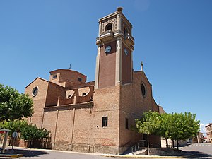
Térmens
Municipality in Catalonia, Spain
Distance: Approx. 518 meters
Latitude and longitude: 41.71944444,0.76166667
Térmens (Catalan pronunciation: [ˈteɾmens]) is a village in the province of Lleida and autonomous community of Catalonia, Spain.

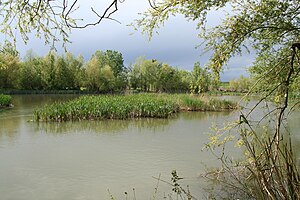
Corb (river)
River in Spain
Distance: Approx. 6242 meters
Latitude and longitude: 41.67795,0.71242
The Corb river (Catalan: el riu Corb or el Riucorb) is a small river in Catalonia, Spain. It rises at a spring near the village of Rauric, just west of the town of Santa Coloma de Queralt in central Catalonia, flows westwards past the villages of Llorac, Vallfogona de Riucorb, Guimerà, Ciutadilla, Nalec, Rocafort de Vallbona, Sant Martí de Maldà, Maldà, Belianes, then veers northwards across the plain where it disappears into a network of irrigation canals. Its original course collects water again near the town of Bellpuig, then flows west until it joins the river Segre at Vilanova de la Barca, north-east of Lleida city.

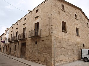
Palauet de la muralla de Balaguer
Distance: Approx. 8679 meters
Latitude and longitude: 41.789,0.8058
Lo Palauet de la Muralla is an old mansion, turned into a hotel, which is located in the historic center of the town of Balaguer (Noguera), in the old Jewish quarter. Located near Plaça Mercadal, its main facade faces Miracle Street, where the adjoining house separates it from the Church of Sant Joseph, which was a synagogue in the past. The back of the house, a part of the old city wall, faces the Segre river.
Weather in this IP's area
overcast clouds
12 Celsius
12 Celsius
12 Celsius
13 Celsius
1021 hPa
83 %
1021 hPa
993 hPa
10000 meters
1.79 m/s
3.13 m/s
77 degree
100 %