185.219.104.45 - IP Lookup: Free IP Address Lookup, Postal Code Lookup, IP Location Lookup, IP ASN, Public IP
Country:
Region:
City:
Location:
Time Zone:
Postal Code:
IP information under different IP Channel
ip-api
Country
Region
City
ASN
Time Zone
ISP
Blacklist
Proxy
Latitude
Longitude
Postal
Route
Luminati
Country
ASN
Time Zone
Europe/London
ISP
Willis Group Services Ltd
Latitude
Longitude
Postal
IPinfo
Country
Region
City
ASN
Time Zone
ISP
Blacklist
Proxy
Latitude
Longitude
Postal
Route
IP2Location
185.219.104.45Country
Region
england
City
ipswich
Time Zone
Europe/London
ISP
Language
User-Agent
Latitude
Longitude
Postal
db-ip
Country
Region
City
ASN
Time Zone
ISP
Blacklist
Proxy
Latitude
Longitude
Postal
Route
ipdata
Country
Region
City
ASN
Time Zone
ISP
Blacklist
Proxy
Latitude
Longitude
Postal
Route
Popular places and events near this IP address

Ipswich
Town and borough in England
Distance: Approx. 29 meters
Latitude and longitude: 52.05944444,1.15555556
Ipswich ( ) is a port town and borough in Suffolk, England. It is the county town, and largest in Suffolk, followed by Lowestoft and Bury St Edmunds, and the third-largest population centre in East Anglia, after Peterborough and Norwich. It is 50 miles (80 km) northeast of London and in 2011 had a population of 144,957.

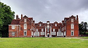
Christchurch Mansion
Historic house and museum in Ipswich, England
Distance: Approx. 250 meters
Latitude and longitude: 52.06062,1.15823
Christchurch Mansion is a substantial Tudor brick mansion house built in Ipswich, Suffolk, England, by Edmund Withypoll (also written "Withipoll") around 1548–50. The Grade I listed building is located within Christchurch Park and sits by the southern gates close to the town centre of Ipswich. The mansion belonged to various noble families throughout its history but was purchased by the Ipswich Borough Council in 1884.

Ancient House, Ipswich
Distance: Approx. 236 meters
Latitude and longitude: 52.057111,1.154794
The Ancient House, also known as Sparrowe's House, is a Grade I listed building dating from the 15th century located in the Buttermarket area of Ipswich, Suffolk, England. In 1980 the building was acquired by Ipswich Borough Council. The building sports detailed pargeting, and also elaborate wood carvings around the front of the house.

St Lawrence Church, Ipswich
Distance: Approx. 206 meters
Latitude and longitude: 52.057389,1.154801
St Lawrence Church is a Grade II* listed church in Ipswich, Suffolk, that is now used as a community centre. The 15th-century church has the oldest ring of five church bells in the world.

St Mary-le-Tower
Church in Suffolk, England
Distance: Approx. 89 meters
Latitude and longitude: 52.0584,1.1554
Ipswich Minster, also known as St Mary-le-Tower, is the civic church of Ipswich, Suffolk, England and a Grade II* listed building. It was in the churchyard of St Mary that the town charter of Ipswich was written in 1200.
Ipswich Castle
Distance: Approx. 121 meters
Latitude and longitude: 52.0584,1.1566
Ipswich Castle was a medieval castle, now vanished, in the town of Ipswich, Suffolk, England.

Ipswich Town Hall
Municipal building in Ipswich, Suffolk, England
Distance: Approx. 259 meters
Latitude and longitude: 52.0577,1.1525
Ipswich Town Hall is a municipal building in Ipswich, in the county of Suffolk, England. It is a Grade II listed building. It is used for meetings of Ipswich Borough Council and also serves as an events venue and art gallery.
Sailmakers Shopping Centre
Shopping mall
Distance: Approx. 123 meters
Latitude and longitude: 52.05835,1.15425
Sailmakers shopping centre (formerly known as Tower Ramparts) is a small multi-story shopping centre located in Ipswich, England. It was opened to the public in November 1986. It is currently owned and operated by LaSalle Investment Management, who purchased the centre in 2011.

The Cornhill, Ipswich
Town square in Ipswich, England
Distance: Approx. 235 meters
Latitude and longitude: 52.0579,1.1527
The Cornhill in Ipswich is a historic town square in the centre of Ipswich, Suffolk. The square has been a gathering place for many centuries in the town, the earliest recorded event was the execution of the Ipswich Martyrs in the 16th century. In the present-day, the Cornhill hosts various events such as Christmas markets, live music shows, and outdoor screenings of notable broadcasts, such as the proms.

Cock and Pye, Ipswich
Historic pub in Ipswich
Distance: Approx. 231 meters
Latitude and longitude: 52.05723,1.15647
The Cock and Pye is public house in Ipswich, Suffolk, England. It is located in Upper Brook Street. It was included in the 1689 list of pubs in Ipswich, where it was stated to be in St Margarets Parish, Ipswich.
Crown Pools
Distance: Approx. 134 meters
Latitude and longitude: 52.0599,1.1538
Crown Pools is a swimming venue in Ipswich that opened in 1984.

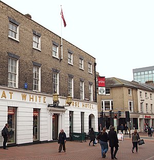
Great White Horse Hotel
Former hotel in Ipswich, Suffolk, England, UK
Distance: Approx. 163 meters
Latitude and longitude: 52.0578,1.1561
The Great White Horse Hotel is a historic inn in the town centre of Ipswich, Suffolk, England. A hotel has existed on the site since 1518. Previously the site – located on the corner of Tavern Street and Northgate Street – had been used as a tavern in medieval times.
Weather in this IP's area
overcast clouds
3 Celsius
-1 Celsius
3 Celsius
4 Celsius
1037 hPa
62 %
1037 hPa
1032 hPa
10000 meters
6.17 m/s
220 degree
100 %
