185.218.29.66 - IP Lookup: Free IP Address Lookup, Postal Code Lookup, IP Location Lookup, IP ASN, Public IP
Country:
 Slovakia
Region:
City:
Location:
Time Zone:
Postal Code:
ISP:
ASN:
language:
User-Agent:
Proxy IP:
Blacklist:
IP information under different IP Channel
ip-api
Country
Region
City
ASN
Time Zone
ISP
Blacklist
Proxy
Latitude
Longitude
Postal
Route
db-ip
Country
Region
City
ASN
Time Zone
ISP
Blacklist
Proxy
Latitude
Longitude
Postal
Route
IPinfo
Country
Region
City
ASN
Time Zone
ISP
Blacklist
Proxy
Latitude
Longitude
Postal
Route
IP2Location
185.218.29.66Country
skRegion
trenciansky kraj
City
nova dubnica
Time Zone
Europe/Bratislava
ISP
Language
User-Agent
Latitude
Longitude
Postal
ipdata
Country
Region
City
ASN
Time Zone
ISP
Blacklist
Proxy
Latitude
Longitude
Postal
Route
Popular places and events near this IP address
Trenčianske Teplice
Town in Slovakia
Distance: Approx. 3368 meters
Latitude and longitude: 48.90833333,18.16861111
Trenčianske Teplice (German: Trentschin-Teplitz; Hungarian: Trencsénteplic) is a health resort and small spa town in western Slovakia, in the valley of the river Teplička, at the foothills of the Strážovské vrchy mountains, a few kilometres away from the city of Trenčín.

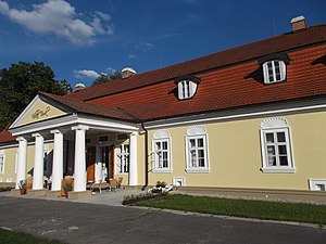
Dubnica nad Váhom
Town in Slovakia
Distance: Approx. 3505 meters
Latitude and longitude: 48.96055556,18.17388889
Dubnica nad Váhom (; Slovak before 1927: Dubnica, German: Dubnitz an der Waag, Hungarian: Máriatölgyes, before 1899 Dubnic(z)) is a town in the Ilava District, Trenčín Region in Slovakia.

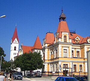
Nová Dubnica
Town in Slovakia
Distance: Approx. 262 meters
Latitude and longitude: 48.93305556,18.14388889
Nová Dubnica (German: Neudubnitz; Hungarian: Újtölgyes; Czech: Nová Dubnice) is a town in Trenčín Region, Slovakia.

Mestský štadión (Dubnica)
Multi-use stadium in Dubnica nad Váhom, Slovakia
Distance: Approx. 3440 meters
Latitude and longitude: 48.96361111,18.16333333
Mestský futbalový štadión is a multi-use stadium in Dubnica nad Váhom, Slovakia. It is currently used mostly for football matches and is the home ground of MFK Dubnica. The stadium holds 5,450 people.

Nemšová
Town in Slovakia
Distance: Approx. 3606 meters
Latitude and longitude: 48.96055556,18.11638889
Nemšová (Hungarian: Nemsó) is a town in the Trenčín District, Trenčín Region in northwestern Slovakia.
Bolešov
Municipality in Slovakia
Distance: Approx. 5409 meters
Latitude and longitude: 48.98333333,18.15
Bolešov (Slovak pronunciation: [ˈbɔleʂɔw]; Hungarian: Bolesó) is a village and municipality in Ilava District in the Trenčín Region of north-western Slovakia.
Borčice
Municipality in Slovakia
Distance: Approx. 5485 meters
Latitude and longitude: 48.98333333,18.13333333
Borčice (Hungarian: Borcsic) is a village and municipality in Ilava District in the Trenčín Region of north-western Slovakia.

Horné Srnie
Village and municipality in Slovakia
Distance: Approx. 6375 meters
Latitude and longitude: 48.98333333,18.1
Horné Srnie (Hungarian: Felsőszernye) is a village and municipality in Trenčín District in the Trenčín Region of north-western Slovakia.

Skalka nad Váhom
Municipality in Slovakia
Distance: Approx. 5478 meters
Latitude and longitude: 48.9275,18.07222222
Skalka nad Váhom ( Hungarian: Vágsziklás ) is a village and municipality in Trenčín District in the Trenčín Region of north-western Slovakia.

Trenčianska Teplá
Distance: Approx. 2173 meters
Latitude and longitude: 48.93333333,18.11666667
Trenčianska Teplá (Hungarian: Hőlak) is a village and municipality in Trenčín District in the Trenčín Region of north-western Slovakia.
Príles
Distance: Approx. 1940 meters
Latitude and longitude: 48.95,18.13333333
Príles (Hungarian: Prilesz) is the local part of Trenčianska Teplá.

Vlára
River in Czech Republic, Slovakia
Distance: Approx. 3411 meters
Latitude and longitude: 48.95611111,18.11277778
The Vlára is a river in the Czech Republic and Slovakia, a right tributary of the Váh. It flows through the Zlín Region in the Czech Republic and through the Trenčín Region in Slovakia. It is 44.7 km (27.8 mi) long.
Weather in this IP's area
overcast clouds
3 Celsius
1 Celsius
1 Celsius
3 Celsius
1033 hPa
71 %
1033 hPa
986 hPa
10000 meters
1.74 m/s
3.07 m/s
115 degree
100 %