Country:
 Belgium
Region:
City:
Latitude and Longitude:
Time Zone:
Postal Code:
IP information under different IP Channel
ip-api
Country
Region
City
ASN
Time Zone
ISP
Blacklist
Proxy
Latitude
Longitude
Postal
Route
IPinfo
Country
Region
City
ASN
Time Zone
ISP
Blacklist
Proxy
Latitude
Longitude
Postal
Route
MaxMind
Country
Region
City
ASN
Time Zone
ISP
Blacklist
Proxy
Latitude
Longitude
Postal
Route
Luminati
Country
BEASN
Time Zone
Europe/Brussels
ISP
Proximus NV
Latitude
Longitude
Postal
db-ip
Country
Region
City
ASN
Time Zone
ISP
Blacklist
Proxy
Latitude
Longitude
Postal
Route
ipdata
Country
Region
City
ASN
Time Zone
ISP
Blacklist
Proxy
Latitude
Longitude
Postal
Route
Popular places and events near this IP address

Tournai
Municipality in Wallonia, Belgium
Distance: Approx. 4379 meters
Latitude and longitude: 50.60555556,3.38805556
Tournai or Tournay ( toor-NAY, French: [tuʁnɛ] ; Picard: Tornai; Walloon: Tornè [tɔʀnɛ] ; Dutch: Doornik [ˈdoːrnɪk] ) is a city and municipality of Wallonia located in the Province of Hainaut, Belgium. It lies 89 km (55 mi) by road southwest of the centre of Brussels on the river Scheldt, and is part of Eurometropolis Lille–Kortrijk–Tournai, In 2022, the municipality of Tournai had an estimated population of 68,518 people. Tournai is one of the oldest cities in Belgium and has played an important role in the country's cultural history.

Belfry of Tournai
Medieval bell tower and UNESCO World Heritage Site in Tournai, Belgium
Distance: Approx. 4379 meters
Latitude and longitude: 50.60555556,3.38805556
The Belfry of Tournai (French: Beffroi de Tournai) is a freestanding bell tower of medieval origin in Tournai, Belgium, 72 metres (236 ft) in height with a 256-step stairway. This landmark building is one of a set of Belfries of Belgium and France registered on the UNESCO World Heritage List in recognition of their civic architecture and importance in the rise of municipal power in Europe.

Battle of Tournay (1794)
1794 battle during the War of the First Coalition
Distance: Approx. 2713 meters
Latitude and longitude: 50.644019,3.344689
The Battle of Tournay or Battle of Tournai or Battle of Pont-à-Chin (22 May 1794) saw Republican French forces led by Jean-Charles Pichegru attack Coalition forces under Emperor Francis II and Prince Josias of Saxe-Coburg-Saalfeld. After a bitter all-day struggle, Coalition troops recaptured a few key positions including Pont-à-Chin, forcing the French to retreat. The Coalition allies included soldiers from Austria, Great Britain, Hanover, and Hesse-Darmstadt.

Musée des Beaux-Arts, Tournai
Art museum in Tournai, Belgium
Distance: Approx. 4354 meters
Latitude and longitude: 50.60277778,3.38555556
The Musée des Beaux-Arts in Tournai, Belgium, is an art museum. At the beginning of the 20th century, Henri Van Cutsem, a Belgian art collector, offered his collection of art to the city of Tournai in 1905. The collection contained important works of important 19th century French painters like Manet, Monet, Seurat and others.

Roman Catholic Diocese of Tournai
Catholic ecclesiastical territory in Belgium
Distance: Approx. 4319 meters
Latitude and longitude: 50.607195,3.388198
The Diocese of Tournai (Latin: Dioecesis Tornacensis) is a Latin Church ecclesiastical territory or diocese of the Catholic Church in Belgium. The diocese was formed in 1146, upon the dissolution of the Diocese of Noyon and Tournai, which had existed since the 7th century. It is now suffragan in the ecclesiastical province of the metropolitan Archdiocese of Mechelen–Brussels.

Templeuve Castle
Castle in Belgium
Distance: Approx. 4246 meters
Latitude and longitude: 50.64495833,3.28414444
Templeuve Castle, also known as Castle of Formanoir de La Cazerie, is a castle in Templeuve Belgium.

Battle of Marquain
Battle of the War of the First Coalition
Distance: Approx. 2564 meters
Latitude and longitude: 50.6,3.317
The Battle of Marquain was a conflict between Austria and the Kingdom of France during the War of the First Coalition. It took place on 29 April 1792 and ended in a French defeat.
Lamain
Distance: Approx. 4122 meters
Latitude and longitude: 50.6,3.28333333
Lamain (Picard: Laman) is a village of Wallonia and a district of the municipality of Tournai, located in the province of Hainaut, Belgium.

Marquain
Village in Belgium
Distance: Approx. 1916 meters
Latitude and longitude: 50.605,3.322
Marquain (French pronunciation: [maʁkɛ̃]) is a village of Wallonia and a district of the municipality of Tournai, located in the province of Hainaut, Belgium.

Church of Saint Quentin, Tournai
Distance: Approx. 4132 meters
Latitude and longitude: 50.60666667,3.385
The Church of St. Quentin (French: Église Saint-Quentin) is a Roman Catholic parish church in Tournai, Belgium. The largely Romanesque building is located on the main square of the town, the Grand-Place.
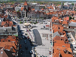
Grand-Place, Tournai
Square in Tournai, Belgium
Distance: Approx. 4234 meters
Latitude and longitude: 50.60638889,3.38638889
The Grand-Place (French: [ɡʁɑ̃ plas]; "Grand Square") is the main square and the centre of activity of Tournai, Hainaut, Belgium. The square has a triangular shape, owing it to the convergence of several ancient roads, and it covers 7,500 m2 (81,000 sq ft). As in many Belgian cities, there are a number of cafés and pubs on the Grand-Place.

Siege of Tournai (1745)
Siege during the War of the Austrian Succession
Distance: Approx. 4379 meters
Latitude and longitude: 50.60555556,3.38805556
The siege of Tournai was a two-month siege of the city and citadel of Tournai, then part of the Austrian Netherlands, in 1745 during the War of the Austrian Succession. The allied Pragmatic Army's attempt to relieve the siege resulted in the decisive French victory at the Battle of Fontenoy on 11 May. The largely Dutch garrison of the city subsequently surrendered to French forces on 22 May, while the garrison of the citadel surrendered on 19 June 1745.
Weather in this IP's area
overcast clouds
13 Celsius
12 Celsius
12 Celsius
13 Celsius
1007 hPa
74 %
1007 hPa
1004 hPa
10000 meters
5.66 m/s
230 degree
100 %
07:47:15
19:25:03