Country:
 Italy
ItalyRegion:
City:
Latitude and Longitude:
Time Zone:
Postal Code:
IP information under different IP Channel
ip-api
Country
Region
City
ASN
Time Zone
ISP
Blacklist
Proxy
Latitude
Longitude
Postal
Route
IPinfo
Country
Region
City
ASN
Time Zone
ISP
Blacklist
Proxy
Latitude
Longitude
Postal
Route
MaxMind
Country
Region
City
ASN
Time Zone
ISP
Blacklist
Proxy
Latitude
Longitude
Postal
Route
Luminati
Country
ITRegion
72
City
battipaglia
ASN
Time Zone
Europe/Rome
ISP
Convergenze S.p.A.
Latitude
Longitude
Postal
db-ip
Country
Region
City
ASN
Time Zone
ISP
Blacklist
Proxy
Latitude
Longitude
Postal
Route
ipdata
Country
Region
City
ASN
Time Zone
ISP
Blacklist
Proxy
Latitude
Longitude
Postal
Route
Popular places and events near this IP address

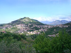
Battipaglia
Comune in Campania, Italy
Distance: Approx. 518 meters
Latitude and longitude: 40.61666667,14.98333333
Battipaglia (pronounced [ˌbattiˈpaʎʎa]) is a municipality (comune) in the province of Salerno, Campania, south-western Italy. Famed as a production place of buffalo mozzarella, Battipaglia is the economic hub of the Sele plain.

Bellizzi
Comune in Campania, Italy
Distance: Approx. 2627 meters
Latitude and longitude: 40.61666667,14.95
Bellizzi is a town and comune in the province of Salerno in the Campania region of south-western Italy.
Montecorvino Rovella
Comune in Campania, Italy
Distance: Approx. 9296 meters
Latitude and longitude: 40.69591667,14.97544444
Montecorvino Rovella (Campanian: Ruella) is a town and comune in the province of Salerno in the Campania region of south-west Italy.

Salerno Costa d'Amalfi Airport
Airport in Campania, Italy
Distance: Approx. 5815 meters
Latitude and longitude: 40.62,14.9125
Salerno Costa d'Amalfi Airport (IATA: QSR, ICAO: LIRI), is an airport located in the comune of Pontecagnano Faiano in southern Italy. It serves the city of Salerno and the coastal areas of Amalfi and Cilento. It is also known as Salerno-Pontecagnano Airport.
PalaSele
Distance: Approx. 6568 meters
Latitude and longitude: 40.610996,15.058291
PalaSele is an indoor sporting arena located in Eboli, Italy. The capacity of the arena is 8,000 spectators. It hosts indoor sporting events such as basketball and volleyball, and also hosts concerts.

Santa Maria La Nova, Campagna
Frazione in Campania, Italy
Distance: Approx. 8545 meters
Latitude and longitude: 40.63055556,15.07888889
Santa Maria La Nova is a hamlet (frazione) of the comune of Campagna in the Province of Salerno, Campania, Italy.
Serretella Airfield
Distance: Approx. 487 meters
Latitude and longitude: 40.60844722,14.98276111
Serretella Airfield is an abandoned World War II military airfield in southeast Italy, which is located in the vicinity of Battipaglia in the province of Salerno in the Campania region of south-western Italy. Its precise location is undetermined. It was an all-weather temporary field built by the XII Engineer Command using a graded earth compacted surface, with a prefabricated hessian (burlap) surfacing known as PHS. PHS was made of an asphalt-impregnated jute which was rolled out over the compacted surface over a square mesh track (SMT) grid of wire joined in 3-inch squares.

Faiano
Frazione in Campania, Italy
Distance: Approx. 8727 meters
Latitude and longitude: 40.66255556,14.90108611
Faiano is an Italian town and hamlet (frazione) of the municipality of Pontecagnano Faiano in the province of Salerno, Campania region. Along with the main town of Pontecagnano it is de jure the secondary seat of its municipality.
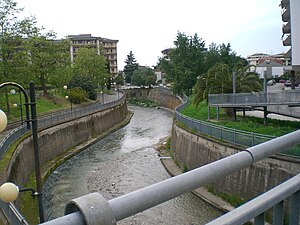
Tusciano
River in Italy
Distance: Approx. 8991 meters
Latitude and longitude: 40.5797,14.8834
The Tusciano is a river of Campania in southern Italy.

Macchia, Montecorvino Rovella
Frazione in Campania, Italy
Distance: Approx. 4709 meters
Latitude and longitude: 40.65480556,14.98058333
Macchia is an Italian village and hamlet (frazione) of the municipality of Montecorvino Rovella in the Province of Salerno, Campania. With a population of 1,933 (2011), is the largest frazione of Montecorvino.
Eboli railway station
Railway station in Eboli, Italy
Distance: Approx. 6126 meters
Latitude and longitude: 40.61083333,15.05305556
Eboli is a railway station in Eboli, Italy. The station is located on the Battipaglia–Metaponto railway. The train services are operated by Trenitalia.

Battipaglia railway station
Railway station in Italy
Distance: Approx. 905 meters
Latitude and longitude: 40.605,14.98472222
Battipaglia is a railway station in Battipaglia, Italy. The station is located on the Salerno–Reggio Calabria railway and Battipaglia–Metaponto railway. The train services are operated by Trenitalia.
Weather in this IP's area
few clouds
18 Celsius
18 Celsius
18 Celsius
19 Celsius
1011 hPa
75 %
1011 hPa
1003 hPa
10000 meters
3.6 m/s
60 degree
20 %
06:42:01
19:07:53