Country:
 Russian Federation
Region:
City:
Latitude and Longitude:
Time Zone:
Postal Code:
IP information under different IP Channel
ip-api
Country
Region
City
ASN
Time Zone
ISP
Blacklist
Proxy
Latitude
Longitude
Postal
Route
IPinfo
Country
Region
City
ASN
Time Zone
ISP
Blacklist
Proxy
Latitude
Longitude
Postal
Route
MaxMind
Country
Region
City
ASN
Time Zone
ISP
Blacklist
Proxy
Latitude
Longitude
Postal
Route
Luminati
Country
RUASN
Time Zone
Europe/Moscow
ISP
OOO L-Telecom
Latitude
Longitude
Postal
db-ip
Country
Region
City
ASN
Time Zone
ISP
Blacklist
Proxy
Latitude
Longitude
Postal
Route
ipdata
Country
Region
City
ASN
Time Zone
ISP
Blacklist
Proxy
Latitude
Longitude
Postal
Route
Popular places and events near this IP address

Tsaritsyno (Moscow Metro)
Moscow Metro station
Distance: Approx. 2430 meters
Latitude and longitude: 55.6214,37.6694
Tsaritsyno (Russian: Царицыно) is a Moscow Metro station in Tsaritsyno District, Southern Administrative Okrug, Moscow. It is on the Zamoskvoretskaya line, between Kantemirovskaya and Orekhovo stations. The entrance is located at the intersection of Luganskaya, Kaspiyskaya and Tovarishchesckaya ('Luhansk', 'Caspian', and 'Tovarishch' streets).

Orekhovo (Moscow Metro)
Moscow Metro station
Distance: Approx. 636 meters
Latitude and longitude: 55.6132,37.6949
Orekhovo (Russian: Орехово) is a Moscow Metro station on the Zamoskvoretskaya Line in Orekhovo-Borisovo Severnoye District, Southern Administrative Okrug, Moscow. Entrances are situated on the edge of Tsaritsyno park, at the intersection of Shipilovsky drive and Bazhenova street. Orekhovo opened on 30 December 1984 as part of an extension but was closed the very next day because of flooding.

Domodedovskaya
Moscow Metro station
Distance: Approx. 886 meters
Latitude and longitude: 55.6108,37.7186
Domodedovskaya (Russian: Домодедовская) is a Moscow Metro station in Orekhovo-Borisovo Severnoye and Orekhovo-Borisovo Yuzhnoye districts, Southern Administrative Okrug, Moscow. It is on the Zamoskvoretskaya Line, between Orekhovo and Krasnogvardeyskaya stations. The station opened on 7 September 1985.

Krasnogvardeyskaya (Moscow Metro)
Moscow Metro station
Distance: Approx. 2479 meters
Latitude and longitude: 55.6137,37.7444
Krasnogvardeyskaya (Russian: Красногварде́йская) is a Moscow Metro station in the Zyablikovo District, Southern Administrative Okrug, Moscow. It is on the Zamoskvoretskaya Line, between Domodedovskaya and Alma-Atinskaya. Krasnogvardeyskaya opened on 7 September 1985 and was named after the former Krasnogvardeysky district.

Orekhovo-Borisovo Severnoye District
District in Moscow, Russia
Distance: Approx. 682 meters
Latitude and longitude: 55.61833333,37.7
Orekhovo-Borisovo Severnoye District (Russian: райо́н Оре́хово-Бори́сово Се́верное), commonly known as Orekhovo-Borisovo, is a district in Southern Administrative Okrug of Moscow, Russia, located on the spot of former villages of Orekhovo, Borisovo, Shipilovo, Zyablikovo, and Brateyevo. In the early 1970s, mass housing construction was started in the area, and a microdistrict was built. Its main landmark is the Orekhovo-Borisovo Cathedral.

Orekhovo-Borisovo Yuzhnoye District
District in Federal city of Moscow, Russia
Distance: Approx. 2288 meters
Latitude and longitude: 55.6,37.73333333
Orekhovo-Borisovo Yuzhnoye District (Russian: райо́н Оре́хово-Бори́сово Ю́жное) is a territorial division (a district, or raion) in Southern Administrative Okrug, one of the 125 in the federal city of Moscow, Russia. It is located in the south of the federal city. The area of the district is 7.197 square kilometers (2.779 sq mi).
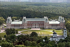
Tsaritsyno Palace
Palace museum and park reserve in Moscow, Russia
Distance: Approx. 1468 meters
Latitude and longitude: 55.615,37.68194444
Tsaritsyno (Russian: Царицыно, IPA: [tsɐˈrʲitsɨnə], literal meaning "Tsaritsa's property") is a palace museum and park reserve in the south of Moscow. It was founded in 1775 as the summer residence of Empress Catherine II, but the construction remained incomplete. For most of its history, it was a half-abandoned park with picturesque ruins.

Muromtsev Dacha
Distance: Approx. 2366 meters
Latitude and longitude: 55.60871389,37.66810556
The Muromtsev Dacha (Russian: Да́ча Му́ромцева) was a wooden dacha built at the end of the 19th century in Moscow’s southern Tsaritsyno District (“historical Muromtsev Dacha”) and largely rebuilt in the 1960s (“modern Muromtsev Dacha”). It was demolished in 2010 The historical Muromtsev Dacha was a three-story wooden building with “Swedish-style” turrets. Because of the damage it suffered in the German-Soviet War, it was dismantled, and a new wooden building was erected on its foundations.
Church of the Holy Trinity at the Borisovo Ponds
Distance: Approx. 1674 meters
Latitude and longitude: 55.627418,37.71192
The Church of the Holy Trinity at the Borisovo Ponds (храм Троицы в Орехове-Борисове) is a metochion of the Patriarch of Moscow on the Kashira Highway in Orekhovo-Borisovo, a residential district in South Moscow. It was built in 2001–2004 to a Byzantine Revival design by Vladimir Kolosnitsyn, an architect favored by Mayor of Moscow, Yuri Luzhkov. Apart from the 70-metre-tall main church, the compound includes a chapel, a free-standing prothesis, a zvonnitsa, and a school.

Zyablikovo District
District in Moscow, Russia
Distance: Approx. 2562 meters
Latitude and longitude: 55.62027778,37.74361111
Zyablikovo District (Russian: район Зябликово) is an administrative district (raion) of Southern Administrative Okrug, and one of the 125 raions of Moscow, Russia. The area of the district is 4,379 square kilometers (1,691 sq mi). As of 2017, it had a population of 131,297.

Zyablikovo (Moscow Metro)
Moscow Metro station
Distance: Approx. 2534 meters
Latitude and longitude: 55.6124,37.7453
Zyablikovo (Russian: Зя́бликово) is a Moscow Metro station in the Zyablikovo District, Southern Administrative Okrug, Moscow. It is located on the Lyublinsko-Dmitrovskaya Line serving as its southern terminus. The station opened on 2 December 2011.

Tsaritsyno railway station
Railway station in Moscow
Distance: Approx. 2370 meters
Latitude and longitude: 55.618472,37.668611
Tsaritsyno is a railway station of Line D2 of the Moscow Central Diameters in Moscow. It was opened in 1865. The current station was built in 1908 according to the project of the architect V.K. Fillipov.
Weather in this IP's area
clear sky
5 Celsius
4 Celsius
4 Celsius
6 Celsius
1034 hPa
64 %
1034 hPa
1011 hPa
10000 meters
1.97 m/s
2.4 m/s
48 degree
7 %
07:06:02
17:22:12