Country:
Region:
City:
Latitude and Longitude:
Time Zone:
Postal Code:
IP information under different IP Channel
ip-api
Country
Region
City
ASN
Time Zone
ISP
Blacklist
Proxy
Latitude
Longitude
Postal
Route
Luminati
Country
Region
idf
City
choisyleroi
ASN
Time Zone
Europe/Paris
ISP
K-NET SARL
Latitude
Longitude
Postal
IPinfo
Country
Region
City
ASN
Time Zone
ISP
Blacklist
Proxy
Latitude
Longitude
Postal
Route
db-ip
Country
Region
City
ASN
Time Zone
ISP
Blacklist
Proxy
Latitude
Longitude
Postal
Route
ipdata
Country
Region
City
ASN
Time Zone
ISP
Blacklist
Proxy
Latitude
Longitude
Postal
Route
Popular places and events near this IP address
Taverny
Commune in Île-de-France, France
Distance: Approx. 2134 meters
Latitude and longitude: 49.0264,2.2275
Taverny (French pronunciation: [tavɛʁni] ) is a commune in the northwestern suburbs of Paris, France. It is located 21.2 km (13.2 mi) from the center of Paris. Inhabitants are called Tabernaciens.

Taverny Air Base
Military unit
Distance: Approx. 1189 meters
Latitude and longitude: 49.03333333,2.21666667
Taverny Air Base (formerly Base Aérienne 921 "Frères Mahé" de Taverny) (ICAO: LFPJ) is located in the communities of Taverny and Bessancourt in the Val d'Oise département of France, twenty kilometers north of Paris. Until 2011 it was the headquarters of the French Air Force nuclear strike force, with an underground command center. The base is divided into three tiers with an area of approximately 15 hectares: The first tier is underground in a former gypsum quarry beneath the Forest of Montmorency.
Bessancourt
Commune in Île-de-France, France
Distance: Approx. 614 meters
Latitude and longitude: 49.0386,2.2142
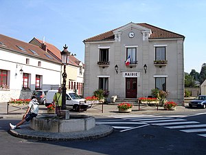
Bessancourt (French pronunciation: [bɛsɑ̃kuʁ] ) is a commune in the Val-d'Oise department in Île-de-France in northern France. Bessancourt station has rail connections to Persan, Saint-Leu-la-Forêt and Paris.

Béthemont-la-Forêt
Commune in Île-de-France, France
Distance: Approx. 2991 meters
Latitude and longitude: 49.0553,2.2531
Béthemont-la-Forêt (French pronunciation: [betmɔ̃ la fɔʁɛ] ) is a commune in the Val-d'Oise department in Île-de-France in northern France.

Frépillon
Commune in Île-de-France, France
Distance: Approx. 1182 meters
Latitude and longitude: 49.0522,2.2056
Frépillon (French pronunciation: [fʁepijɔ̃] ) is a commune in the Val-d'Oise department and Île-de-France region of France. Frépillon station has rail connections to Persan, Saint-Leu-la-Forêt and Paris.

Villiers-Adam
Commune in Île-de-France, France
Distance: Approx. 2792 meters
Latitude and longitude: 49.0653,2.2361
Villiers-Adam (French pronunciation: [vilje adɑ̃] ) is a commune in the Val-d'Oise department in Île-de-France in northern France.
Méry-sur-Oise station
French railway station
Distance: Approx. 2387 meters
Latitude and longitude: 49.05777778,2.19083333
Méry-sur-Oise is a railway station in the commune of Méry-sur-Oise (Val-d'Oise department), France. The station is served by Transilien H trains, on the line from Paris to Persan-Beaumont via Saint-Leu-la-Forêt. The daily number of passengers was between 500 and 2,500 in 2002.

Frépillon station
French railway station
Distance: Approx. 1408 meters
Latitude and longitude: 49.04638889,2.19694444
Frépillon is a railway station in the commune of Frépillon (Val-d'Oise department), France. The station is served by Transilien H trains from Paris to Persan-Beaumont via Saint-Leu-la-Forêt. The daily number of passengers was less than 500 in 2002.

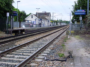
Bessancourt station
French railway station
Distance: Approx. 1015 meters
Latitude and longitude: 49.03583333,2.20972222
Bessancourt is a railway station in the commune of Bessancourt (Val-d'Oise department), France. The station is served by Transilien H trains from Paris to Persan-Beaumont via Saint-Leu-la-Forêt. The daily number of passengers was between 500 and 2,500 in 2002.

Taverny station
Distance: Approx. 2122 meters
Latitude and longitude: 49.02527778,2.22138889
Taverny is a railway station located in the commune of Taverny (Val-d'Oise department), France. The station is served by Transilien H trains, on the line from Paris to Persan-Beaumont via Saint-Leu-la-Forêt. The daily number of passengers was between 500 and 2,500 in 2002.
Vaucelles station
Railway station in Taverny, France
Distance: Approx. 2735 meters
Latitude and longitude: 49.02138889,2.23055556
Vaucelles is a railway station located in the commune of Taverny (Val-d'Oise department), France. The station is served by Transilien H trains, on the line from Paris to Persan-Beaumont. The daily number of passengers was between 500 and 2,500 in 2002.
Canton of Taverny
Distance: Approx. 2688 meters
Latitude and longitude: 49.02,2.22
The canton of Taverny is an administrative division of the Val-d'Oise department, Île-de-France region, northern France. Its borders were modified at the French canton reorganisation which came into effect in March 2015. Its seat is in Taverny.
Weather in this IP's area
mist
6 Celsius
4 Celsius
5 Celsius
8 Celsius
1025 hPa
100 %
1025 hPa
1007 hPa
4000 meters
3.6 m/s
60 degree
100 %
07:50:10
17:19:42

