Country:
Region:
City:
Latitude and Longitude:
Time Zone:
Postal Code:
IP information under different IP Channel
ip-api
Country
Region
City
ASN
Time Zone
ISP
Blacklist
Proxy
Latitude
Longitude
Postal
Route
Luminati
Country
Region
vc
City
orihuela
ASN
Time Zone
Europe/Madrid
ISP
Telfy Telecom S.L.
Latitude
Longitude
Postal
IPinfo
Country
Region
City
ASN
Time Zone
ISP
Blacklist
Proxy
Latitude
Longitude
Postal
Route
db-ip
Country
Region
City
ASN
Time Zone
ISP
Blacklist
Proxy
Latitude
Longitude
Postal
Route
ipdata
Country
Region
City
ASN
Time Zone
ISP
Blacklist
Proxy
Latitude
Longitude
Postal
Route
Popular places and events near this IP address

Orihuela
Municipality in Valencian Community, Spain
Distance: Approx. 1255 meters
Latitude and longitude: 38.08555556,-0.94694444
Orihuela (Spanish: [oɾiˈwela] ; Valencian: Oriola) is a city and municipality located at the foot of the Sierra de Orihuela mountains in the province of Alicante, Valencian Community, Spain. The city is in one of the only Spanish-speaking areas of the Valencian Community. The city of Orihuela had a population of 33,943 inhabitants at the beginning of 2013.

Vega Baja del Segura
Comarca in Valencian Community, Spain
Distance: Approx. 1420 meters
Latitude and longitude: 38.08416667,-0.945
Vega Baja del Segura (Spanish: [ˈbeɣa ˈβaxa ðel seˈɣuɾa]; Valencian: Baix Segura [ˈbajʃ seˈɣuɾa]), simply known locally and regionally as Vega Baja (in Spanish), is a comarca in the province of Alicante, Valencian Community, Spain. The region is only Spanish-speaking, except Guardamar del Segura where Valencian is the traditional local language. To the north its neighbouring comarcas are the Baix Vinalopó and Vinalopó Mitjà.
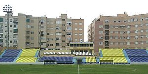
Estadio Municipal Los Arcos
Distance: Approx. 990 meters
Latitude and longitude: 38.08333333,-0.95
Estadio Municipal de Los Arcos is a football ground in Orihuela in Valencian Community, Spain. It is the home of the Orihuela CF football team. The first official match played in Los Arcos was a Torneo Vega Baja game organized by Federación Murciana de Fútbol on May 13, 1945.

Roman Catholic Diocese of Orihuela-Alicante
Diocese of the Catholic Church in Spain
Distance: Approx. 1286 meters
Latitude and longitude: 38.0857,-0.9466
The Diocese of Orihuela-Alicante (Latin: Dioecesis Oriolensis-Lucentinus) is a Latin Church diocese of the Catholic Church located in the cities of Orihuela and Alicante in the ecclesiastical province of Valencia in Spain. It was established as Diocese of Orihuela from the Diocese of Cartagena in 1564, obtaining its current denomination in 1959.
Battle of Oriola (1521)
Distance: Approx. 1255 meters
Latitude and longitude: 38.08555556,-0.94694444
The Battle of Oriola was an armed conflict fought between the troops of the Agermanats (members of the Revolt of the Brotherhoods), mainly artisan guilds, and those of Pedro Fajardo y Chacón, Marqués de los Vélez, on 30 August 1521 in Oriola (Orihuela), in the Kingdom of Valencia (now in Spain). The events were marked by strong internal disputes amongst the Agermanats (members of the Revolt of the Brotherhoods), which were divided between moderates and radicals. This led to a significant decline in their forces, just over a month after the Battle of Gandia.

Sierra de Orihuela
Mountain range in Valencia, Spain
Distance: Approx. 2677 meters
Latitude and longitude: 38.10777778,-0.96888889
Sierra de Orihuela (Valencian: Serra d'Oriola) is a 9.4 km (6 mi) long mountain range in the Vega Baja del Segura (Valencian: Baix Segura) comarca, Valencian Community, Spain. Its highest point is Peña de Orihuela (634 m). This range is named after the town of Orihuela (Valencian: Oriola), located at the feet of the mountains.
Orihuela Cathedral
Distance: Approx. 1355 meters
Latitude and longitude: 38.08583333,-0.94583333
Orihuela Cathedral (Catedral de Orihuela) is the main Roman Catholic church of Orihuela, Valencian Community, southern Spain.
University of Orihuela
Historic site in Alicante, Spain
Distance: Approx. 1844 meters
Latitude and longitude: 38.0894,-0.9411
The University of Orihuela was located at the Convent of Santo Domingo, in Orihuela. It was the second university in the ancient Kingdom of Valencia, founded 40 years after the University of Valencia. The official name of the institution was Pontificia y Real Universidad de Orihuela (Pontifical and Royal University of Orihuela).

Camino de Beniel
Place in Valencian Community, Spain
Distance: Approx. 535 meters
Latitude and longitude: 38.08014722,-0.95860278
Camino de Beniel is a village in Alicante, Spain. It is part of the municipality of Orihuela.

Correntías Medias
Place in Alicante, Spain
Distance: Approx. 2859 meters
Latitude and longitude: 38.077,-0.93
Correntías Medias is a village in Alicante, Spain.

El Escorratel
Place in Alicante, Spain
Distance: Approx. 3293 meters
Latitude and longitude: 38.101,-0.93
El Escorratel is a village in Alicante, Spain. It is part of the municipality of Orihuela.

La Aparecida
Place in Alicante, Spain
Distance: Approx. 4206 meters
Latitude and longitude: 38.081,-1.009
La Aparecida is a village in Alicante, Spain. It is part of the municipality of Orihuela.
Weather in this IP's area
overcast clouds
16 Celsius
16 Celsius
15 Celsius
18 Celsius
1020 hPa
80 %
1020 hPa
1017 hPa
10000 meters
2.24 m/s
4.02 m/s
99 degree
90 %
07:45:09
17:52:05


