185.213.155.234 - IP Lookup: Free IP Address Lookup, Postal Code Lookup, IP Location Lookup, IP ASN, Public IP
Country:
Region:
City:
Location:
Time Zone:
Postal Code:
IP information under different IP Channel
ip-api
Country
Region
City
ASN
Time Zone
ISP
Blacklist
Proxy
Latitude
Longitude
Postal
Route
Luminati
Country
Region
he
City
frankfurtammain
ASN
Time Zone
Europe/Berlin
ISP
31173 Services AB
Latitude
Longitude
Postal
IPinfo
Country
Region
City
ASN
Time Zone
ISP
Blacklist
Proxy
Latitude
Longitude
Postal
Route
IP2Location
185.213.155.234Country
Region
hessen
City
taunusstein
Time Zone
Europe/Berlin
ISP
Language
User-Agent
Latitude
Longitude
Postal
db-ip
Country
Region
City
ASN
Time Zone
ISP
Blacklist
Proxy
Latitude
Longitude
Postal
Route
ipdata
Country
Region
City
ASN
Time Zone
ISP
Blacklist
Proxy
Latitude
Longitude
Postal
Route
Popular places and events near this IP address
Rheingau-Taunus-Kreis
District in Hesse, Germany
Distance: Approx. 5626 meters
Latitude and longitude: 50.148403,8.073267
Rheingau-Taunus is a Kreis (district) in the west of Hesse, Germany. Rheingau-Taunus-Kreis is part of the Darmstadt region; its main administrative seat is Bad Schwalbach. Outposted sections of the local administration are located in Idstein and Rüdesheim am Rhein.
Bad Schwalbach
Town in Hesse, Germany
Distance: Approx. 6368 meters
Latitude and longitude: 50.13333333,8.06666667
Bad Schwalbach (called Langenschwalbach until 1927) is the district seat of Rheingau-Taunus-Kreis, in Hesse, Germany.

Taunusstein
Town in Hesse, Germany
Distance: Approx. 1850 meters
Latitude and longitude: 50.13333333,8.15
Taunusstein (German: [ˈtaʊnʊsˌʃtaɪn] ) is the biggest town in the Rheingau-Taunus-Kreis in the Regierungsbezirk of Darmstadt in Hessen, Germany. It has 30,068 inhabitants (2020).

Stadion am Halberg
Stadium in Taunusstein, Germany
Distance: Approx. 2531 meters
Latitude and longitude: 50.16,8.18388889
Stadion am Halberg is a multi-use stadium in Taunusstein, Germany. It is the former home venue of the footballclub of SV Wehen, before the team moved to the newly built BRITA-Arena in Wiesbaden. The stadium has a capacity of 5,000 people, and is located on the Halberg, in the Wehen district of the town.
Lindschied
Stadtteil of Bad Schwalbach in Hesse, Germany
Distance: Approx. 6368 meters
Latitude and longitude: 50.13333333,8.06666667
Lindschied is a village in Hesse, Germany. It is part of Bad Schwalbach, lies in the hills of the Taunus and has about 600 inhabitants. In the time of the Roman Empire, the border-wall called limes went through Lindschied's boundaries.
Klarenthal Abbey
Distance: Approx. 6887 meters
Latitude and longitude: 50.0958,8.1989
Klarenthal Abbey (Kloster Klarenthal in German) is a former convent of the Order of Poor Ladies in the borough of Klarenthal in Wiesbaden, Germany. Klarenthal is the only abbey in present-day Wiesbaden.

Rhine-Taunus Nature Park
Distance: Approx. 2286 meters
Latitude and longitude: 50.13,8.16
The Rhine Taunus Nature Park (German: Naturpark Rhein-Taunus), located in the Rheingau-Taunus-Kreis and Wiesbaden district of Hesse, Germany was founded in 1968. It includes the western part of the Taunus and extends over the Idsteiner Becken to the Rhine. It is characterized by a roughly 60 percent forested low mountain landscape, which falls away steeply toward the Rhine Gorge.

Hohe Wurzel (Taunus)
Distance: Approx. 4787 meters
Latitude and longitude: 50.10861111,8.13333333
Hohe Wurzel, at 618 m, is the highest peak in the Rheingau-Taunus-Kreis mountain range and the 2nd highest mountain near Wiesbaden, Hesse, Germany. A 133 m reinforced concrete telecommunications tower is located on the peak, which supplies the Rhine Main area and other locations with digital television service as well as DAB and FM sound broadcasts. In 1883, the Gustav Vietor Tower was built on the peak.
Schläferskopf
Distance: Approx. 4784 meters
Latitude and longitude: 50.108,8.167
The Schläferskopf is a hill in Hesse, Germany, which is 454 metres high.

Aar Valley Railway
Railway line in Germany
Distance: Approx. 5502 meters
Latitude and longitude: 50.16058889,8.07678889
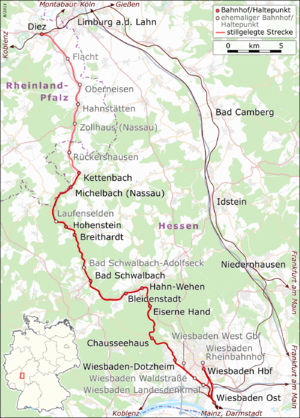
The Aar Valley Railway (German: Aartalbahn) is a 53.7 km long line between Wiesbaden, the capital of the German state of Hesse, and Diez in Rhineland-Palatinate. From 1985 to 2009, the southern end was operated as a heritage railway with historic trains. The Hessian part of the line is heritage-listed.
Gustav Vietor Tower
Distance: Approx. 4780 meters
Latitude and longitude: 50.10833333,8.13527778
The Gustav Vietor Tower was one of the earliest steel lattice observation towers to be built in Germany. Constructed of stone and steel in 1882–3 on the Hohe Wurzel mountain near Wiesbaden in Hesse, the 23-metre-tall tower was demolished in 2006, having been closed to visitors 20 years earlier, although it remained in use by radio amateurs.
Kastell Zugmantel
Distance: Approx. 5747 meters
Latitude and longitude: 50.1897,8.20344
Kastell Zugmantel (Latin name unknown) is a former Roman garrison site designed for a complement the size of a cohort. The facility is located on the western Taunus section of the Upper Germanic-Rhaetian Limes, and has been a UNESCO World Heritage Site since 2005. The above-ground remains in the area, still very visible, are located in a forest edge area of Taunusstein-Orlen in the Hessian Rheingau-Taunus-Kreis.
Weather in this IP's area
few clouds
-5 Celsius
-5 Celsius
-7 Celsius
-4 Celsius
1037 hPa
90 %
1037 hPa
1000 hPa
10000 meters
20 %

