Country:
 Great Britain
Region:
City:
Latitude and Longitude:
Time Zone:
Postal Code:
IP information under different IP Channel
ip-api
Country
Region
City
ASN
Time Zone
ISP
Blacklist
Proxy
Latitude
Longitude
Postal
Route
IPinfo
Country
Region
City
ASN
Time Zone
ISP
Blacklist
Proxy
Latitude
Longitude
Postal
Route
MaxMind
Country
Region
City
ASN
Time Zone
ISP
Blacklist
Proxy
Latitude
Longitude
Postal
Route
Luminati
Country
GBRegion
eng
City
london
ASN
Time Zone
Europe/London
ISP
xTom GmbH
Latitude
Longitude
Postal
db-ip
Country
Region
City
ASN
Time Zone
ISP
Blacklist
Proxy
Latitude
Longitude
Postal
Route
ipdata
Country
Region
City
ASN
Time Zone
ISP
Blacklist
Proxy
Latitude
Longitude
Postal
Route
Popular places and events near this IP address
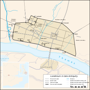
Londinium
Settlement established on the current site of the City of London around 43–50 AD
Distance: Approx. 33 meters
Latitude and longitude: 51.5125,-0.09055556
Londinium, also known as Roman London, was the capital of Roman Britain during most of the period of Roman rule. Most twenty-first century historians think that it was originally a settlement established shortly after the Claudian invasion of Britain, on the current site of the City of London around 47–50 AD, but some defend an older view that the city originated in a defensive enclosure constructed during the Claudian invasion in 43 AD. Its earliest securely-dated structure is a timber drain of 47 AD. It sat at a key ford at the River Thames which turned the city into a road nexus and major port (which was built between 49 and 52 AD), serving as a major commercial centre in Roman Britain until its abandonment during the 5th century. Following the foundation of the town in the mid-1st century, early Londinium occupied the relatively small area of 1.4 km2 (0.5 sq mi), roughly half the area of the modern City of London and equivalent to the size of present-day Hyde Park.

Worshipful Company of Tallow Chandlers
Livery company of the City of London
Distance: Approx. 105 meters
Latitude and longitude: 51.51136,-0.09108
The Worshipful Company of Tallow Chandlers is one of the ancient livery companies of the City of London. The organisation, which engaged not only in tallow candle making but also in the trade of oils, first received a Royal Charter in 1462. Traditionally tallow chandlers operated separately from wax chandlers: beeswax candles customarily being used in churches and noble houses, while tallow (animal fat) candles were generally used in other homes.
Worshipful Company of Curriers
Livery company of the City of London
Distance: Approx. 105 meters
Latitude and longitude: 51.51136,-0.09108
The Worshipful Company of Curriers is one of the ancient livery companies of London, associated with the leather trade. The curriers, or "curers of leather", of London formed an organisation in 1272; this merchant guild was recognised in 1415 by Ordinances of the City Common Council before its grant of a Royal Charter by King James I in 1605. The company now exists, as do most other livery companies, as an education and charitable institution, the traditional process of currying having been made more or less obsolete by technological advances.

Walbrook
Ward of the City of London
Distance: Approx. 63 meters
Latitude and longitude: 51.5124,-0.09
Walbrook is a Ward of the City of London and a minor street in its vicinity. The ward is named after a river of the same name. The ward of Walbrook contains two of the City's most notable landmarks: the Bank of England and the Mansion House.
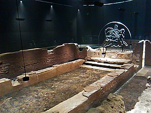
London Mithraeum
Mithraeum in the United Kingdom
Distance: Approx. 30 meters
Latitude and longitude: 51.5125,-0.0906
The London Mithraeum, also known as the Temple of Mithras, Walbrook, is a Roman Mithraeum that was discovered in Walbrook, a street in the City of London, during a building's construction in 1954. The entire site was relocated to permit continued construction and this temple of the mystery god Mithras became perhaps the most famous 20th-century Roman discovery in London.
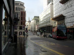
Cannon Street
Street in London
Distance: Approx. 82 meters
Latitude and longitude: 51.51194444,-0.09194444
Cannon Street is a road in the City of London, the historic nucleus of London and its modern financial centre. It runs roughly parallel with the River Thames, about 250 metres (820 ft) north of it, in the south of the City. It is the site of the ancient London Stone and gave its name to Cannon Street station, a mainline railway terminus and connected London Underground station.
St Stephen Walbrook
Church in London , United Kingdom
Distance: Approx. 77 meters
Latitude and longitude: 51.51262778,-0.08991944
St Stephen Walbrook is a church in the City of London, part of the Church of England's Diocese of London. The present domed building was erected to the designs of Sir Christopher Wren following the destruction of its medieval predecessor in the Great Fire of London in 1666. It is located in Walbrook, next to the Mansion House, and near to Bank and Monument Underground stations.
Steelyard
Trading post of the Hanseatic League in London
Distance: Approx. 104 meters
Latitude and longitude: 51.51138889,-0.09055556
The Steelyard, from the Middle Low German Stâlhof (sample yard), was the kontor (foreign trading post) of the Hanseatic League in London, and their main trading base in England, between the 13th and 16th centuries. The main goods that the League exported from London were wool and from the 14th century woollen cloths. An important import good was beeswax.
St Benet Sherehog
Former church in London
Distance: Approx. 105 meters
Latitude and longitude: 51.51319444,-0.09138889
St Benet Sherehog, additionally dedicated to St Osyth, was a medieval parish church built before the year 1111, on a site now occupied by No 1 Poultry in Cordwainer Ward, in what was then the wool-dealing district of the City of London. A shere hog is a castrated ram after its first shearing.
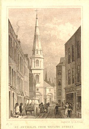
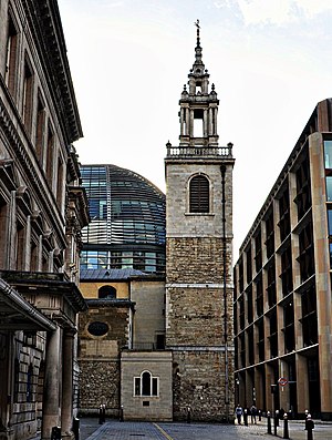
St Antholin, Budge Row
Former church-site in London
Distance: Approx. 76 meters
Latitude and longitude: 51.5125,-0.09194444
St Antholin, Budge Row, or St Antholin, Watling Street, was a church in the City of London. Of medieval origin, it was rebuilt to the designs of Sir Christopher Wren, following its destruction in the Great Fire of London in 1666. The 17th-century building was demolished in 1874.

Walbrook Club
Dining club in London
Distance: Approx. 83 meters
Latitude and longitude: 51.5126,-0.0898
The Walbrook Club is a social and business dining club near the Bank of England and the Mansion House located in the Ward of Walbrook in London. The Club is set in a Queen Anne-style townhouse at the end of a private court next door to the UK offices of Rothschild's, the Church of St Stephen's, and opposite the Bloomberg European Headquarters. There is a bar, a dining room, and two smaller private rooms.
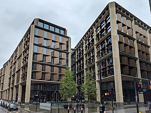
Bloomberg London
Building in London
Distance: Approx. 22 meters
Latitude and longitude: 51.5125,-0.0909
Bloomberg London is an office building in the City of London, which was opened in 2017. It is owned by Bloomberg L.P. and functions as their European headquarters. It is at 3 Queen Victoria Street, to the west of Walbrook, on the site previously occupied by Bucklersbury House.
Weather in this IP's area
overcast clouds
16 Celsius
16 Celsius
15 Celsius
17 Celsius
1026 hPa
89 %
1026 hPa
1022 hPa
10000 meters
3.09 m/s
30 degree
100 %
06:42:09
19:06:04