Country:
Region:
City:
Latitude and Longitude:
Time Zone:
Postal Code:
IP information under different IP Channel
ip-api
Country
Region
City
ASN
Time Zone
ISP
Blacklist
Proxy
Latitude
Longitude
Postal
Route
Luminati
Country
Region
cl
City
tordesillas
ASN
Time Zone
Europe/Madrid
ISP
Telfy Telecom S.L.
Latitude
Longitude
Postal
IPinfo
Country
Region
City
ASN
Time Zone
ISP
Blacklist
Proxy
Latitude
Longitude
Postal
Route
db-ip
Country
Region
City
ASN
Time Zone
ISP
Blacklist
Proxy
Latitude
Longitude
Postal
Route
ipdata
Country
Region
City
ASN
Time Zone
ISP
Blacklist
Proxy
Latitude
Longitude
Postal
Route
Popular places and events near this IP address
Tordesillas
Municipality in Castile and León, Spain
Distance: Approx. 168 meters
Latitude and longitude: 41.5,-5
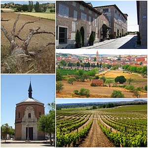
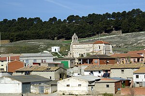
Tordesillas (Spanish pronunciation: [toɾðeˈsiʎas]) is a town and municipality in the province of Valladolid, Castile and León, central Spain. It is located 25 kilometres (16 mi) southwest of the provincial capital, Valladolid at an elevation of 704 metres (2,310 ft). The population was c.

Rueda, Valladolid
Place in Castile and León, Spain
Distance: Approx. 9975 meters
Latitude and longitude: 41.414,-4.96
Rueda is a village and municipality in the province of Valladolid, part of the autonomous community of Castile-Leon, Spain. It is located 30 km southwest of the provincial capital, the city of Valladolid. The population is 1.614 This locality is also the center for the wine denomination Rueda (DO).

Bercero
Place in Castile and León, Spain
Distance: Approx. 8665 meters
Latitude and longitude: 41.56666667,-5.05
Bercero is a municipality located in the province of Valladolid, Castile and León, Spain. According to the 2004 census (INE), the municipality has a population of 248 inhabitants.

Berceruelo
Place in Castile and León, Spain
Distance: Approx. 9848 meters
Latitude and longitude: 41.58333333,-5.03333333
Berceruelo is a municipality located in the province of Valladolid, Castile and León, Spain. According to the 2004 census (INE), the municipality has a population of 41 inhabitants.

Matilla de los Caños
Place in Castile and León, Spain
Distance: Approx. 6366 meters
Latitude and longitude: 41.55,-4.9666
Matilla de los Caños is a municipality located in the province of Valladolid, Castile and León, Spain. According to the 2004 census (INE), the municipality has a population of 111 inhabitants.

San Miguel del Pino
Place in Castile and León, Spain
Distance: Approx. 8322 meters
Latitude and longitude: 41.5,-4.9
San Miguel del Pino is a municipality located in the province of Valladolid, Castile and León, Spain. According to the 2004 census (INE), the municipality has a population of 217 inhabitants.
Torrecilla de la Abadesa
Place in Castile and León, Spain
Distance: Approx. 7167 meters
Latitude and longitude: 41.48333333,-5.08333333
Torrecilla de la Abadesa is a municipality located in the province of Valladolid, Castile and León, Spain. According to the 2004 census (INE), the municipality has a population of 326 inhabitants.
Velilla
Place in Castile and León, Spain
Distance: Approx. 6668 meters
Latitude and longitude: 41.5583,-5.0044
Velilla is a municipality located in the province of Valladolid, Castile and León, Spain. According to the 2004 census (INE), the municipality has a population of 138 inhabitants.

Royal Convent of Santa Clara
Distance: Approx. 274 meters
Latitude and longitude: 41.5,-4.9972
The Royal Convent of Santa Clara is a nunnery in Tordesillas, Spain. Founded by king Pedro of Castile in 1363, this convent of Poor Clares is now under the administration of Spain's national heritage organisation, the Patrimonio Nacional but still supports a community of 8 cloistered nuns as of 2024. It is noted for its mudéjar architecture, such as the ceiling of the church.
Weather in this IP's area
overcast clouds
10 Celsius
8 Celsius
10 Celsius
10 Celsius
1019 hPa
78 %
1019 hPa
938 hPa
10000 meters
3.51 m/s
6.23 m/s
97 degree
100 %
08:09:09
18:00:24

