Country:
 Poland
Region:
City:
Latitude and Longitude:
Time Zone:
Postal Code:
IP information under different IP Channel
ip-api
Country
Region
City
ASN
Time Zone
ISP
Blacklist
Proxy
Latitude
Longitude
Postal
Route
IPinfo
Country
Region
City
ASN
Time Zone
ISP
Blacklist
Proxy
Latitude
Longitude
Postal
Route
MaxMind
Country
Region
City
ASN
Time Zone
ISP
Blacklist
Proxy
Latitude
Longitude
Postal
Route
Luminati
Country
PLRegion
22
City
chojnice
ASN
Time Zone
Europe/Warsaw
ISP
Centrum Komputerowe partnet Miroslaw Wolszlegier
Latitude
Longitude
Postal
db-ip
Country
Region
City
ASN
Time Zone
ISP
Blacklist
Proxy
Latitude
Longitude
Postal
Route
ipdata
Country
Region
City
ASN
Time Zone
ISP
Blacklist
Proxy
Latitude
Longitude
Postal
Route
Popular places and events near this IP address

Chojnice
Place in Pomeranian Voivodeship, Poland
Distance: Approx. 906 meters
Latitude and longitude: 53.7,17.55
Chojnice (Polish: [xɔjˈɲit͡sɛ] ; Kashubian: Chònice or Chòjnice; German: Konitz or Conitz) is a town in northern Poland with 38,789 inhabitants, as of June 2023, near the Tuchola Forest. It is the capital of the Chojnice County in the Pomeranian Voivodeship.

Battle of Chojnice (1454)
Part of the Thirteen Years' War
Distance: Approx. 398 meters
Latitude and longitude: 53.7,17.566667
The Battle of Chojnice (or Battle of Konitz) occurred on 18 September 1454 near the town of Chojnice, between Poland and the Teutonic Knights during the Thirteen Years' War. The battle was won by the Teutonic Knights.
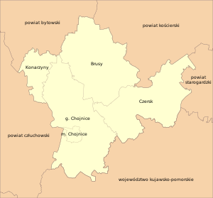
Chojnice County
County in Pomeranian Voivodeship, Poland
Distance: Approx. 906 meters
Latitude and longitude: 53.7,17.55
Chojnice County (Kashubian: Chòniczzi kréz, Polish: powiat chojnicki) is a unit of territorial administration and local government (powiat) in Pomeranian Voivodeship, northern Poland. It came into being on January 1, 1999, as a result of the Polish local government reforms in 1998. Its administrative seat and largest town is Chojnice, which lies 103 kilometres (64 mi) south-west of the regional capital Gdańsk.

Battle of Chojnice (1656)
1656 battle
Distance: Approx. 398 meters
Latitude and longitude: 53.7,17.566667
The Battle of Chojnice, also known as the Battle of Konitz, was a surprise nighttime attack followed by a run-and-chase battle during The Deluge.
Battle of Chojnice (1939)
Distance: Approx. 398 meters
Latitude and longitude: 53.7,17.566667
The Battle of Chojnice occurred during the 1939 German invasion of Poland on the first day of the hostilities, 1 September. A detached unit from the Polish army Chojnice Detached Group under Colonel Kazimierz Tadeusz Majewski, part of the Czersk Operational Group under Stanisław Grzmot-Skotnicki, was assigned the task of defending the city of Chojnice, a major regional communications center, against the advancing German 20th Motorized Infantry Division in order to protect the southern flank of Army Pomorze. The German attacks started at 04:30 with Stuka dive bombers, from 3/1 Stuka Geschwader, attacking the Tczew bridge.
Gmina Chojnice
Gmina in Pomeranian Voivodeship, Poland
Distance: Approx. 906 meters
Latitude and longitude: 53.7,17.55
Gmina Chojnice (Kashubian: Chojnice) is a rural gmina (administrative district) in Chojnice County, Pomeranian Voivodeship, in northern Poland. Its seat is the town of Chojnice, although the town is not part of the territory of the gmina. The gmina covers an area of 458.34 square kilometres (177.0 sq mi), and as of 2006 its total population is 16,014.
Chojnaty
Village in Pomeranian Voivodeship, Poland
Distance: Approx. 2699 meters
Latitude and longitude: 53.67722222,17.58611111
Chojnaty [xɔi̯ˈnatɨ] is a village in the administrative district of Gmina Chojnice, within Chojnice County, Pomeranian Voivodeship, in northern Poland. It lies approximately 4 kilometres (2 mi) south-east of Chojnice and 103 km (64 mi) south-west of the regional capital Gdańsk. For details of the history of the region, see History of Pomerania.
Chojniczki-Wybudowanie
Settlement in Pomeranian Voivodeship, Poland
Distance: Approx. 3032 meters
Latitude and longitude: 53.72361111,17.55166667
Chojniczki-Wybudowanie [xɔi̯ˈnit͡ʂki vɨbudɔˈvaɲɛ] is a settlement in the administrative district of Gmina Chojnice, within Chojnice County, Pomeranian Voivodeship, in northern Poland. It lies approximately 3 kilometres (2 mi) north of Chojnice and 101 km (63 mi) south-west of the regional capital Gdańsk. For details of the history of the region, see History of Pomerania.
Karolewo, Gmina Chojnice
Settlement in Pomeranian Voivodeship, Poland
Distance: Approx. 2374 meters
Latitude and longitude: 53.71027778,17.53444444
Karolewo [karɔˈlɛvɔ] is a settlement in the administrative district of Gmina Chojnice, within Chojnice County, Pomeranian Voivodeship, in northern Poland. It lies approximately 2 kilometres (1 mi) north-west of Chojnice and 103 km (64 mi) south-west of the regional capital Gdańsk. For details of the history of the region, see History of Pomerania.
Klawkowo
Village in Pomeranian Voivodeship, Poland
Distance: Approx. 3067 meters
Latitude and longitude: 53.71194444,17.60222222
Klawkowo [klafˈkɔvɔ] is a village in the administrative district of Gmina Chojnice, within Chojnice County, Pomeranian Voivodeship, in northern Poland. It lies approximately 4 kilometres (2 mi) east of Chojnice and 100 km (62 mi) south-west of the regional capital Gdańsk. For details of the history of the region, see History of Pomerania.
Topole, Pomeranian Voivodeship
Village in Pomeranian Voivodeship, Poland
Distance: Approx. 3028 meters
Latitude and longitude: 53.69305556,17.5175
Topole [tɔˈpɔlɛ] is a village in the administrative district of Gmina Chojnice, within Chojnice County, Pomeranian Voivodeship, in northern Poland. It lies approximately 3 kilometres (2 mi) west of Chojnice and 105 km (65 mi) south-west of the regional capital Gdańsk. For details of the history of the region, see History of Pomerania.
Władysławek
Village in Pomeranian Voivodeship, Poland
Distance: Approx. 2669 meters
Latitude and longitude: 53.69888889,17.5225
Władysławek [vwadɨˈswavɛk] is a village in the administrative district of Gmina Chojnice, within Chojnice County, Pomeranian Voivodeship, in northern Poland. It lies approximately 2 kilometres (1 mi) west of Chojnice and 104 km (65 mi) south-west of the regional capital Gdańsk. For details of the history of the region, see History of Pomerania.
Weather in this IP's area
overcast clouds
9 Celsius
6 Celsius
9 Celsius
9 Celsius
1021 hPa
49 %
1021 hPa
1003 hPa
10000 meters
5.98 m/s
15.18 m/s
136 degree
99 %
07:22:58
17:46:24