185.206.143.171 - IP Lookup: Free IP Address Lookup, Postal Code Lookup, IP Location Lookup, IP ASN, Public IP
Country:
Region:
City:
Location:
Time Zone:
Postal Code:
IP information under different IP Channel
ip-api
Country
Region
City
ASN
Time Zone
ISP
Blacklist
Proxy
Latitude
Longitude
Postal
Route
Luminati
Country
ASN
Time Zone
Europe/Amsterdam
ISP
Linfosys BV
Latitude
Longitude
Postal
IPinfo
Country
Region
City
ASN
Time Zone
ISP
Blacklist
Proxy
Latitude
Longitude
Postal
Route
IP2Location
185.206.143.171Country
Region
noord-brabant
City
goirle
Time Zone
Europe/Amsterdam
ISP
Language
User-Agent
Latitude
Longitude
Postal
db-ip
Country
Region
City
ASN
Time Zone
ISP
Blacklist
Proxy
Latitude
Longitude
Postal
Route
ipdata
Country
Region
City
ASN
Time Zone
ISP
Blacklist
Proxy
Latitude
Longitude
Postal
Route
Popular places and events near this IP address

Tilburg
City in North Brabant, Netherlands
Distance: Approx. 3449 meters
Latitude and longitude: 51.55,5.08333333
Tilburg (Dutch: [ˈtɪlbʏr(ə)x] ) is a city and municipality in the Netherlands, in the southern province of North Brabant. With a population of 222,601 (1 July 2021), it is the second-largest city or municipality in North Brabant after Eindhoven and the seventh-largest in the Netherlands. Tilburg University is located in Tilburg, as are Avans University of Applied Sciences and Fontys University of Applied Sciences.
Goirle
Municipality in North Brabant, Netherlands
Distance: Approx. 460 meters
Latitude and longitude: 51.51666667,5.06666667
Goirle (pronounced [ˈɣoːrlə] ) is a municipality and town in the southern Netherlands, in the province of North Brabant. Part of the suburban area of the city of Tilburg, it shares with it its phone area code and public transport system. The municipality also includes the villages of Breehees and Riel.
Willem II College
Distance: Approx. 2594 meters
Latitude and longitude: 51.5413,5.0845
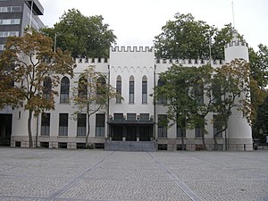
Koning Willem II College is a school in Tilburg in the Netherlands. It was established in 1866 and is named after King Willem II. The school was founded in the former royal palace in Tilburg, the present City Hall, of which the construction was commissioned by King William II himself. In 1934 the school moved from the former palace to the new location a new and much bigger building at the Ringbaan Oost in Tilburg.

Koning Willem II Stadion
Football stadium in Tilburg, the Netherlands
Distance: Approx. 2447 meters
Latitude and longitude: 51.54277778,5.06694444
Koning Willem II Stadion (Dutch pronunciation: [ˌkoːnɪŋ ˌʋɪləm ˈtʋeː ˌstaːdijɔn]) is a multi-purpose stadium in Tilburg, Netherlands, and the home ground of Willem II Tilburg. It is currently used mostly for football matches. The stadium is able to hold 14,700 people, was built in 1995 and renovated in 2000 to add business lodges, a restaurant, conference rooms, business club and a supporters bar to the main building.
Riel, Netherlands
Village in North Brabant, Netherlands
Distance: Approx. 3138 meters
Latitude and longitude: 51.52388889,5.02166667
Riel is a village (Dutch: dorp) in the municipality of Goirle, south of Tilburg in the province of North Brabant. Until 1997 it belonged to the municipality Alphen en Riel. On the east it is bordered by the stream valley of the river Donge, on the west by the deactivated railroad Turnhout- Tilburg.
Safaripark Beekse Bergen
Wildlife zoo in the Netherlands
Distance: Approx. 2965 meters
Latitude and longitude: 51.51944444,5.10944444
Safaripark Beekse Bergen is the largest wildlife zoo of the Benelux region and provides a home to approximately 1,250 animals from over 150 species, varying from small mammals to large birds. It is located between the cities of Tilburg and Hilvarenbeek in the south of the Netherlands. The visitors can for instance watch zebras and giraffes on the spacious savannahs.

Speelland Beekse Bergen
Distance: Approx. 4097 meters
Latitude and longitude: 51.527,5.125
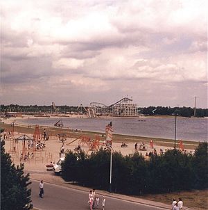
Speelland Beekse Bergen is an amusement park and playground near Hilvarenbeek, Netherlands. It is a part of the Beekse Bergen group, which also owns Safaripark Beekse Bergen. The park has been a part of Libéma Exploitatie since 1987.

City Hall of Tilburg
Distance: Approx. 4025 meters
Latitude and longitude: 51.55471389,5.08686389
The City Hall of Tilburg or Palace-Council House (Dutch: Paleis-Raadhuis) is a former royal palace and presently a part of Tilburg city hall in the Netherlands. Construction of the palace was commissioned by King William II of the Netherlands, who placed the cornerstone on 13 August 1847. The King wanted to have a country residence in Tilburg.
Willem II (women)
Defunct Dutch women's football (soccer) club
Distance: Approx. 2447 meters
Latitude and longitude: 51.54277778,5.06694444
Willem II Vrouwen was the women's football section of Willem II football club from Tilburg, the Netherlands. They were founder members of the Eredivisie Vrouwen in 2007. In their first season, they finished second out of six teams, the highest finish they would have.

Restaurant Monarh
Restaurant in Tilburg, Netherlands
Distance: Approx. 3874 meters
Latitude and longitude: 51.55555556,5.06958333
Restaurant Monarh is a restaurant located in a former monastery in the Dutch city Tilburg. It received one Michelin star in the 2019 Michelin Guide and thus became the first such restaurant in Tilburg.

Gerardus Majellakerk (Tilburg)
Church in North Brabant, Netherlands
Distance: Approx. 3290 meters
Latitude and longitude: 51.54927778,5.07941667
The Gerardus Majellakerk ("Gerard Majella Church"; also Sint-Gerardus Majellakerk or Trouwlaankerk) is a Roman Catholic church located in southern Tilburg along the Wassenaerlaan. It is dedicated to Gerard Majella, who became a saint in 1904, and has been part of the parish De Goede Herder ("The Good Shepherd") since its inception in 2012. Designed by Joseph Cuypers and his son Pierre Cuypers jr., the church was built at the center of a new neighborhood and was completed in 1923.

Fontys School of Fine and Performing Arts
Fine and performing arts school in Tilburg, Netherlands
Distance: Approx. 3911 meters
Latitude and longitude: 51.55405556,5.08491667
The Fontys School of Fine and Performing Arts (Dutch: Fontys Hogeschool voor de Kunsten - FHK) is a Dutch vocational university of the arts located in Tilburg, part of the Fontys Hogescholen. The School originated from the merging of various educational institutions that had existed in different capacity before being united under the Fontys group. Among the precursors of the School was the Brabants Conservatorium, one of the nine conservatoires in the Netherlands.
Weather in this IP's area
overcast clouds
5 Celsius
2 Celsius
4 Celsius
6 Celsius
1026 hPa
97 %
1026 hPa
1024 hPa
2900 meters
4.63 m/s
190 degree
100 %


