Country:
Region:
City:
Latitude and Longitude:
Time Zone:
Postal Code:
IP information under different IP Channel
ip-api
Country
Region
City
ASN
Time Zone
ISP
Blacklist
Proxy
Latitude
Longitude
Postal
Route
Luminati
Country
Region
an
City
pizarra
ASN
Time Zone
Europe/Madrid
ISP
Free Technologies Excom S.L.
Latitude
Longitude
Postal
IPinfo
Country
Region
City
ASN
Time Zone
ISP
Blacklist
Proxy
Latitude
Longitude
Postal
Route
db-ip
Country
Region
City
ASN
Time Zone
ISP
Blacklist
Proxy
Latitude
Longitude
Postal
Route
ipdata
Country
Region
City
ASN
Time Zone
ISP
Blacklist
Proxy
Latitude
Longitude
Postal
Route
Popular places and events near this IP address

Province of Málaga
Province of Spain
Distance: Approx. 979 meters
Latitude and longitude: 36.71666667,-4.41666667
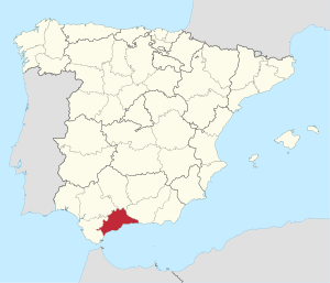
The province of Málaga (Spanish: Provincia de Málaga [ˈmalaɣa]) is located in Andalusia, Spain. It is bordered by the Mediterranean Sea to the south and by the provinces of Cádiz to the west, Seville to the northwest, Córdoba to the north, and Granada to the east. The province is subject to extreme water stress in the wake of the proliferation of avocado plantations in the Axarquía region, with the arid local climate being unsuitable to the plant's large water demands.
Battle of Málaga (1937)
Battle in the Spanish Civil War
Distance: Approx. 984 meters
Latitude and longitude: 36.7167,-4.4167
The Battle of Málaga was the culmination of an offensive in early 1937 by the combined Nationalist and Italian forces, with air and naval support from Nazi Germany, to eliminate Republican control of the province of Málaga during the Spanish Civil War. The participation of Moroccan regulars and Italian tanks from the recently arrived Corpo Truppe Volontarie resulted in a complete rout of the Spanish Republican Army and the capitulation of Málaga in less than a week.

Spania
Province of the Eastern Roman Empire
Distance: Approx. 984 meters
Latitude and longitude: 36.7167,-4.4167
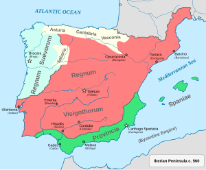
Spania (Latin: Provincia Spaniae) was a province of the Eastern Roman Empire from 552 until 624 in the south of the Iberian Peninsula and the Balearic Islands. It was established by the Emperor Justinian I in an effort to restore the western provinces of the Empire.

Port of Málaga
Port in Spain
Distance: Approx. 979 meters
Latitude and longitude: 36.71666667,-4.41666667
The Port of Málaga is an international seaport located in the city of Málaga in southern Spain, on the Costa del Sol coast of the Mediterranean. It is the oldest continuously-operated port in Spain and one of the oldest in the Mediterranean. Principal port activities include cruise shipping and the importation of containerised manufactured products, break bulk and vehicles.

Málaga (Congress of Deputies constituency)
Distance: Approx. 979 meters
Latitude and longitude: 36.71666667,-4.41666667
Málaga is one of the 52 constituencies (Spanish: circunscripciones) represented in the Congress of Deputies, the lower chamber of the Spanish parliament, the Cortes Generales. The constituency currently elects 11 deputies. Its boundaries correspond to those of the Spanish province of Málaga.
University of Málaga
Public university in Málaga, Spain
Distance: Approx. 1165 meters
Latitude and longitude: 36.72,-4.41611111
The University of Málaga (UMA, Universidad de Málaga) is a public university ranked 23 among all Spanish universities and 683 in the world. It was established in 1972 and has, as of 2016, 30,203 Bachelor students and 2576 on a Master's program, 1255 tenured and 1056 temporary teachers. The UMA offers 65 degree courses and 6 double degrees, over 21 doctoral programmes, 64 master's Degrees, and 100 courses throughout the academic year.

English Cemetery, Málaga
Anglican cemetery of Málaga
Distance: Approx. 969 meters
Latitude and longitude: 36.7212,-4.4071
The English Cemetery in Málaga (Spanish: Cementerio Inglés de Málaga), or Anglican Cemetery, or Cemetery of St George, is the oldest non-Roman Catholic Christian cemetery established on mainland Spain.

Plaza de toros de La Malagueta
Bullring in Málaga, Spain
Distance: Approx. 936 meters
Latitude and longitude: 36.72033333,-4.41080556
La Malagueta is a bullring at Málaga, Andalucía, Spain. It is located in the eastern district of Málaga, in its namesake neighbourhood of La Malagueta. The first event was held in 1876.

Málaga (Parliament of Andalusia constituency)
Distance: Approx. 979 meters
Latitude and longitude: 36.71666667,-4.41666667
Málaga is one of the eight constituencies (Spanish: circunscripciones) represented in the Parliament of Andalusia, the regional legislature of the Autonomous Community of Andalusia. The constituency currently elects 17 deputies. Its boundaries correspond to those of the Spanish province of Málaga.

Málaga (Senate constituency)
Distance: Approx. 979 meters
Latitude and longitude: 36.71666667,-4.41666667
Málaga is one of the 59 constituencies (Spanish: circunscripciones) represented in the Senate of Spain, the upper chamber of the Spanish parliament, the Cortes Generales. The constituency elects four senators. Its boundaries correspond to those of the Spanish province of Málaga.

Reding Fountain
Historic fountain in Málaga, Spain
Distance: Approx. 1013 meters
Latitude and longitude: 36.72150278,-4.40533889
The Reding Fountain is a historic 17th-century fountain located in the Andalusian city of Málaga, Spain. It has been reproduced countless times by local painters. It is located at one end of the Príes Avenue and pipes spring water from the Mount Gibralfaro.

Málaga Public Health Committee
Distance: Approx. 979 meters
Latitude and longitude: 36.71666667,-4.41666667
The Málaga Public Health Committee (Spanish: Comité de Salud Pública de Málaga) was a revolutionary organization that emerged after the coup d'état that gave way to the Spanish Civil War, between the Nationalists and the Republicans. This entity was in charge of managing all political and social affairs until the city fell to the nationalist forces.
Weather in this IP's area
overcast clouds
18 Celsius
18 Celsius
17 Celsius
18 Celsius
1015 hPa
89 %
1015 hPa
1015 hPa
10000 meters
0.89 m/s
1.34 m/s
293 degree
90 %
07:56:01
18:08:47