185.204.211.94 - IP Lookup: Free IP Address Lookup, Postal Code Lookup, IP Location Lookup, IP ASN, Public IP
Country:
 France
Region:
City:
Location:
Time Zone:
Postal Code:
ISP:
ASN:
language:
User-Agent:
Proxy IP:
Blacklist:
IP information under different IP Channel
ip-api
Country
Region
City
ASN
Time Zone
ISP
Blacklist
Proxy
Latitude
Longitude
Postal
Route
db-ip
Country
Region
City
ASN
Time Zone
ISP
Blacklist
Proxy
Latitude
Longitude
Postal
Route
IPinfo
Country
Region
City
ASN
Time Zone
ISP
Blacklist
Proxy
Latitude
Longitude
Postal
Route
IP2Location
185.204.211.94Country
frRegion
provence-alpes-cote-d'azur
City
orange
Time Zone
Europe/Paris
ISP
Language
User-Agent
Latitude
Longitude
Postal
ipdata
Country
Region
City
ASN
Time Zone
ISP
Blacklist
Proxy
Latitude
Longitude
Postal
Route
Popular places and events near this IP address

Orange, Vaucluse
Commune in Provence-Alpes-Côte d'Azur, France
Distance: Approx. 175 meters
Latitude and longitude: 44.1383,4.8097
Orange (French pronunciation: [ɔʁɑ̃ʒ] ; Provençal: Aurenja (classical norm) or Aurenjo (Mistralian norm)) is a commune in the Vaucluse department in the Provence-Alpes-Côte d'Azur region in Southeastern France. It is about 21 km (13 mi) north of Avignon, on the departmental border with Gard, which follows the Rhône and also constitutes the regional border with Occitania. Orange is the second-most populated city in Vaucluse, after Avignon.
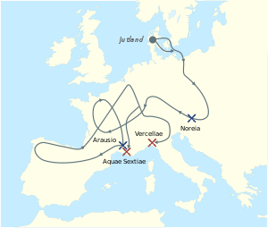
Battle of Arausio
Battle during Cimbrian War (105 BC)
Distance: Approx. 908 meters
Latitude and longitude: 44.13333306,4.8
The Battle of Arausio took place on 6 October 105 BC, at a site between the town of Arausio, now Orange, Vaucluse, and the Rhône river, where two Roman armies, commanded by proconsul Quintus Servilius Caepio and consul Gnaeus Mallius Maximus, were heavily defeated after clashing with the migratory tribes of the Cimbri under Boiorix and the Teutons under Teutobod. Differences between the Roman commanders prevented regular coordination between their armies, resulting in annihilation by the united Cimbrian-Teutonic force. Roman losses are thought to have been up to 80,000 legionaries in addition to 40,000 auxiliary troops.

Principality of Orange
Feudal state in modern-day France (1163–1713)
Distance: Approx. 190 meters
Latitude and longitude: 44.14,4.81
The Principality of Orange (French: Principauté d'Orange) was, from 1163 to 1713, a feudal state in Provence, in the south of modern-day France, on the east bank of the river Rhone, north of the city of Avignon, and surrounded by the independent papal state of Comtat Venaissin. It was constituted in 1163, when Holy Roman Emperor Frederick I elevated the Burgundian County of Orange (consisting of the city of Orange and the land surrounding it) to a sovereign principality within the Empire. The principality became part of the scattered holdings of the house of Orange-Nassau from the time that William the Silent inherited the title of Prince of Orange from his cousin in 1544, until it was finally ceded to France in 1713 under the Treaty of Utrecht.

Chorégies d'Orange
Annual opera festival in France
Distance: Approx. 385 meters
Latitude and longitude: 44.1358,4.8088
The Chorégies d'Orange is a summer opera festival held each August in Orange located about 21 kilometres north of Avignon in southern France. Performances are presented in the ancient Roman theatre, the Théâtre Antique d'Orange, the original stage wall of which has remained intact, creating a semi-circular auditorium which seats 9,000. A festival began in Orange in 1860 and was held periodically, but it was only after the Roman theatre was restored in 1869 that it became the location of a popular “Roman Festival” which celebrated the glory of Rome and included a performance of Méhul’s opera, Joseph.
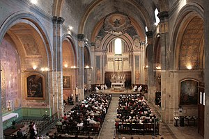
Orange Cathedral
Church in France
Distance: Approx. 138 meters
Latitude and longitude: 44.13805556,4.80722222
Orange Cathedral (Cathédrale Notre-Dame-de-Nazareth d'Orange) is a Roman Catholic church and former cathedral, and national monument of France, located in the town of Orange, Vaucluse.

Orange-Caritat Air Base
Airport in Vaucluse, France
Distance: Approx. 4851 meters
Latitude and longitude: 44.14,4.86861111
Air Base 115 Orange-Caritat (French: Base aérienne 115 Orange-Caritat "Capitaine de Seyne" or BA 115, ICAO: LFMO) is a French Air and Space Force (Armée de l'air et de l'espace) base in Vaucluse, France. It is equipped with one runway and was named after Maurice de Seynes, a French-Soviet aircraft pilot. It is located 5 kilometres (3 mi) east of Orange, a commune in the Vaucluse department of the Provence-Alpes-Côte d'Azur region in France.

Battle of the Rhône Crossing
Battle of the Second Punic War
Distance: Approx. 175 meters
Latitude and longitude: 44.13833306,4.80972194
The Battle of the Rhône Crossing was a battle during the Second Punic War in September of 218 BC. Hannibal marched on the Italian Alps, and an army of Gallic Volcae attacked the Carthaginian army on the east bank of the Rhône. The Roman army camped near Massalia. The Volcae tried to prevent the Carthaginians from crossing the Alps and invading Italy.

Ancient Diocese of Orange
Former Roman Catholic diocese in France
Distance: Approx. 190 meters
Latitude and longitude: 44.14,4.81
The ancient residential diocese of Orange in the Comtat Venaissin in Provence, a fief belonging to the papacy, was suppressed by the French government during the French Revolution. It was revived in 2009 as a titular see of the Catholic Church.

Triumphal Arch of Orange
UNESCO World Heritage Site commemorating veterans of Rome's Gallic Wars
Distance: Approx. 377 meters
Latitude and longitude: 44.14191667,4.80508333
The Triumphal Arch of Orange (French: Arc de triomphe d'Orange) is a triumphal arch located in the town of Orange, southeast France. There is debate about when the arch was built, but current research that accepts the inscription as evidence (27 BC–AD 14) favours a date during the reign of emperor Augustus. It was built on the former via Agrippa to honor the veterans of the Gallic Wars and Legio II Augusta.

Canton of Orange-Ouest
Former canton in Provence-Alpes-Côte d'Azur, France
Distance: Approx. 2611 meters
Latitude and longitude: 44.11944444,4.79027778
The canton of Orange-Ouest is a French former administrative division in the department of Vaucluse and region Provence-Alpes-Côte d'Azur. It had 24,579 inhabitants (2012). It was disbanded following the French canton reorganisation which came into effect in March 2015.

Canton of Orange
Canton in Provence-Alpes-Côte d'Azur, France
Distance: Approx. 190 meters
Latitude and longitude: 44.14,4.81
The canton of Orange is an administrative division of the Vaucluse department, in southeastern France. It was created at the French canton reorganisation which came into effect in March 2015. Its seat is in Orange.

Roman Theatre of Orange
UNESCO World Heritage Site in Vaucluse, France
Distance: Approx. 389 meters
Latitude and longitude: 44.13572222,4.80841667
The Roman Theatre of Orange (French: Théâtre antique d'Orange) is a Roman theatre in Orange, Vaucluse, France. It was built early in the 1st century AD. The structure is owned by the municipality of Orange and is the home of the summer opera festival, the Chorégies d'Orange. It is one of the best preserved of all Roman theatres, and served the Roman colony of Arausio (or, more specifically, Colonia Julia Firma Secundanorum Arausio: "the Julian colony of Arausio established by the soldiers of the second legion") which was founded in 40 BC. Playing a major role in the life of the citizens, who spent a large part of their free time there, the theatre was seen by the Roman authorities not only as a means of spreading Roman culture to the colonies, but also as a way of distracting them from all political activities.
Weather in this IP's area
light rain
11 Celsius
10 Celsius
10 Celsius
11 Celsius
1019 hPa
66 %
1019 hPa
1012 hPa
10000 meters
9.26 m/s
140 degree
75 %