Country:
Region:
City:
Latitude and Longitude:
Time Zone:
Postal Code:
IP information under different IP Channel
ip-api
Country
Region
City
ASN
Time Zone
ISP
Blacklist
Proxy
Latitude
Longitude
Postal
Route
Luminati
Country
ASN
Time Zone
Asia/Tehran
ISP
Ertebatat Sabet Parsian Co. PJS
Latitude
Longitude
Postal
IPinfo
Country
Region
City
ASN
Time Zone
ISP
Blacklist
Proxy
Latitude
Longitude
Postal
Route
db-ip
Country
Region
City
ASN
Time Zone
ISP
Blacklist
Proxy
Latitude
Longitude
Postal
Route
ipdata
Country
Region
City
ASN
Time Zone
ISP
Blacklist
Proxy
Latitude
Longitude
Postal
Route
Popular places and events near this IP address

Valiasr Street
Street in Tehran, Iran
Distance: Approx. 579 meters
Latitude and longitude: 35.732826,51.411112
Valiasr Street (Persian: خیابان ولیعصر), formerly known as the Pahlavi Street (Persian: خیابان پهلوی), is a tree-lined street in Tehran, dividing the metropolis into western and eastern parts which were built in 1922 to 1927 respectively, considering the end of asphalt plan it ended in 1933. It is considered one of Tehran's main thoroughfares and commercial centers. It is also the longest street in the Middle East, and was reported as one of the longest in the world by former BBC (now Al Jazeera) journalist Rageh Omaar during the television documentary Welcome to Tehran.

Yusef Abad Synagogue
Orthodox synagogue in Tehran, Iran
Distance: Approx. 1174 meters
Latitude and longitude: 35.7275,51.4092
The Yusef Abad Synagogue (Persian: کنیسه یوسف آباد, romanized: Kanise-ye Yusef Ābād; Hebrew: בית הכנסת יוסף-אבד), officially Sukkot Shalom Synagogue (Hebrew: סוֹכַּת שָׁאלוֹם, lit. 'Tent of Peace'), is an Orthodox Jewish congregation and synagogue, located at the junction of 15th Street and Sayyed Jamáleddin e Asadábádi Ave, in the Yusef Abad neighborhood of Tehran, in Iran. It is the main synagogue of Tehran, and it is also one of the largest synagogues of the city.

Iran Air Flight 291
1980 deadly plane crash in Tehran, Iran
Distance: Approx. 422 meters
Latitude and longitude: 35.73333333,51.41666667
Iran Air Flight 291 was a flight from Mashad Airport to Tehran-Mehrabad Airport that crashed on 21 January 1980 during its approach to Tehran-Mehrabad runway 29 in foggy and snowy weather conditions, killing all 128 people on board. At the time, Iran Air Flight 291 was the deadliest aircraft disaster in Iranian history.

Shahid Beheshti Metro Station
Station of the Tehran Metro
Distance: Approx. 1210 meters
Latitude and longitude: 35.73163056,51.42681389
Beheshti Metro Station is a station in Tehran Metro Line 1. It is located in the junction of Dr. Mofatteh Street and Beheshti Street.
Mosalla Metro Station
Station of the Tehran Metro
Distance: Approx. 1209 meters
Latitude and longitude: 35.73997778,51.42792778
Mosalla Imam Khomeini Metro Station is a station in Tehran Metro Line 1. It is located in Mosalla-ye Tehran next to Resalat Expressway. It is between Shahid Beheshti Metro Station and Shahid Hemmat Metro Station.

Azadi Cinema Complex
Cinema in Tehran, Iran
Distance: Approx. 989 meters
Latitude and longitude: 35.72805556,51.41611111
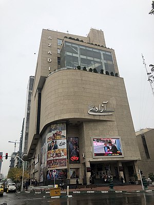
Azadi Cinema Complex is a cineplex building located at Beheshti Street in Tehran. It is used for movie premieres and various entertainment events.
Abbasabad, Rey
Village in Tehran, Iran
Distance: Approx. 1048 meters
Latitude and longitude: 35.73472222,51.42638889
Abbasabad (Persian: عباسآباد, also Romanized as ‘Abbāsābād and Abasabad) is a village in Azimiyeh Rural District, in the Central District of Ray County, Tehran Province, Iran. At the 2006 census, its population was 5,683, in 1,373 families.

Export Development Bank of Iran
Iranian banking and financial services corporation
Distance: Approx. 213 meters
Latitude and longitude: 35.735006,51.415398
Export Development Bank of Iran (EDBI) (Persian: بانک توسعه صادرات ايران, Bank Tuse'h-e Sadârat-e Iran) is Iran's export-import bank. The bank was incorporated as a policy bank, owned by the Iranian government, and provides financial and other conventional banking services to Iranian exporters and importers.

Arjantin Square
Distance: Approx. 35 meters
Latitude and longitude: 35.73708333,51.41541667
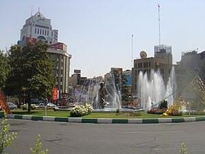
Arjantin Square is a square in north central Tehran. The area around the square is home to embassies, businesses, Medical labs, hospitals and the Arjantin Beihaghi Bus Terminal, which is central Tehran's main national bus terminal.
Rah-e Danesh Synagogue
Synagogue in Tehran, Iran
Distance: Approx. 1260 meters
Latitude and longitude: 35.72807,51.406373
Rah-e Danesh Synagogue is a Jewish congregation and synagogue, located near Yusefabad Street in Tehran, Iran.

Grand Mosalla mosque of Tehran
Mosque in Tehran, Iran
Distance: Approx. 954 meters
Latitude and longitude: 35.7348404,51.425354
The Grand Mosalla Mosque of Tehran is a mosque in Tehran, Iran. It is used for hosting weekly Friday prayer, as well as cultural, political, educational, worship activities, including book fairs, exhibitions, and religious ceremonies. Under construction since the 1990s with a Persian-Islamic architecture, this mammoth mosque will be the second-largest mosque in the world after the Imam Reza Shrine in Mashhad, and it will have the world's biggest Iwan when completed.
Foundation for the Preservation and Publication of Sacred Defense Works and Values
Iranian government agency on preserving the cultural products of the Iran-Iraq war
Distance: Approx. 1174 meters
Latitude and longitude: 35.7275837,51.4211863
The Foundation for the Preservation and Publication of Sacred Defense Works and Values (Persian: بنیاد حفظ آثار و نشر ارزشهای دفاع مقدس) is one of the institutions of the Islamic Republic of Iran with the aim of preserving the relics and disseminating the values of the Sacred Defense (Iran-Iraq war known by Iranians as the "Sacred Defence" or "Holy Defense") and promoting the culture of resistance, self-sacrifice, jihad and martyrdom. It was established by order of the Supreme Leader of Iran at the end of Iran-Iraq war in October 1990. This foundation is headed by Sardar Bahman Kargar and its parent department is General Staff of the Armed Forces of the Islamic Republic of Iran.
Weather in this IP's area
broken clouds
13 Celsius
11 Celsius
11 Celsius
13 Celsius
1026 hPa
38 %
1026 hPa
876 hPa
10000 meters
2.57 m/s
240 degree
75 %
06:33:28
17:02:47