Country:
Region:
City:
Latitude and Longitude:
Time Zone:
Postal Code:
IP information under different IP Channel
ip-api
Country
Region
City
ASN
Time Zone
ISP
Blacklist
Proxy
Latitude
Longitude
Postal
Route
Luminati
Country
Region
an
City
sanlucardebarrameda
ASN
Time Zone
Europe/Madrid
ISP
Airecom Internet, S.L.
Latitude
Longitude
Postal
IPinfo
Country
Region
City
ASN
Time Zone
ISP
Blacklist
Proxy
Latitude
Longitude
Postal
Route
db-ip
Country
Region
City
ASN
Time Zone
ISP
Blacklist
Proxy
Latitude
Longitude
Postal
Route
ipdata
Country
Region
City
ASN
Time Zone
ISP
Blacklist
Proxy
Latitude
Longitude
Postal
Route
Popular places and events near this IP address

Guadalquivir
River in Spain
Distance: Approx. 679 meters
Latitude and longitude: 36.78333333,-6.35
The Guadalquivir (, also UK: , US: , Spanish: [ɡwaðalkiˈβiɾ]) is the fifth-longest river in the Iberian Peninsula and the second-longest river with its entire length in Spain. The Guadalquivir is the only major navigable river in Spain. Currently it is navigable from Seville to the Gulf of Cádiz, but in Roman times it was navigable from Córdoba.

Sanlúcar de Barrameda
City in Andalucía, Spain known for cuisine, history, and tourism
Distance: Approx. 1396 meters
Latitude and longitude: 36.76666667,-6.35
Sanlúcar de Barrameda (Spanish pronunciation: [sanˈlukaɾ ðe βaraˈmeða]), or simply Sanlúcar, is a city in the northwest of Cádiz province, part of the autonomous community of Andalucía in southern Spain. Sanlúcar is located on the left bank at the mouth of the Guadalquivir River opposite the Doñana National Park, 52 km from the provincial capital Cádiz and 119 km from Sevilla capital of the autonomous region Andalucía. Its population is 68,656 inhabitants (National Institute of Statistics 2019).

Manzanilla (wine)
A type of Spanish fortified wine
Distance: Approx. 1185 meters
Latitude and longitude: 36.77361111,-6.35694444
Manzanilla is a fortified wine similar to fino sherry made in the port of Sanlúcar de Barrameda, in the province of Cádiz, Andalusia (Spain), and is produced under the Spanish Denominación de Origen Protegida (DOP) of Manzanilla-Sanlúcar de Barrameda DOP. In Spanish, chamomile infusion is called "manzanilla", and thus this wine gets the name because the wine's aroma is said to be reminiscent of such infusion. Manzanilla is manufactured using the same methods as a fino sherry and results in a very pale, dry wine. It is often described as having a savoury and salty flavour, believed to develop from the chalky soil near the sea estuary of the Guadalquivir river.
Atlético Sanluqueño CF
Association football club
Distance: Approx. 1316 meters
Latitude and longitude: 36.766951,-6.347704
Atlético Sanluqueño Club de Fútbol is a Spanish football team based in Sanlúcar de Barrameda, Province of Cádiz, in the autonomous community of Andalusia. Founded in 1948, although its registration in official competitions took place in 1951. It plays in Primera Federación – Group 2, holding home games at Estadio El Palmar, with a capacity of 5,000 seats.
Bajo Guadalquivir
Comarca in Andalusia, Spain
Distance: Approx. 3251 meters
Latitude and longitude: 36.75166667,-6.33111111
The comarca of Bajo Guadalquivir is a comarca in the province of Seville, in Andalucia, Spain. A Spanish comarca is roughly the equivalent of a county in the United States or Canada, a riding in the United Kingdom, or a Landkreis in Germany.

Bonanza, Spain
Port in Spain
Distance: Approx. 2654 meters
Latitude and longitude: 36.801,-6.335
Bonanza is a port in the city of Sanlúcar de Barrameda, in the province of Cádiz and the community of Andalusia, Spain.
Hidalgo (sherry)
Distance: Approx. 916 meters
Latitude and longitude: 36.7796,-6.3554
Hidalgo is a sherry producer based in Sanlúcar de Barrameda, Andalusia, Spain, whose origins can be traced back to the 18th century. The bodega produces a variety of brands and types of Sherry. Its La Gitana manzanilla is one of the best selling manzanilla sherries.

Battle of Carteia
Distance: Approx. 679 meters
Latitude and longitude: 36.78333333,-6.35
The Battle of Carteia, also known by the modern name Battle of the Guadalquivir, took place during the Second Punic War in 206 BC between the forces of Carthage and the Roman Republic. The name "Battle of the Guadalquivir" is anachronistic, since the river's name "el Guadalquivir", from the Arabic al-wadi al-kabir ("the great valley"), was not used until the Islamic conquest of Spain over nine hundred years after the battle. The Carthaginian forces were commanded by Hanno and the Romans by Gaius Lucius Marcius Septimus.

Ermita del Cerro de los Mártires
Distance: Approx. 5185 meters
Latitude and longitude: 36.73333333,-6.35888889
Ermita del Cerro de los Mártires is a church located in San Fernando in the Province of Cádiz, Andalusia, Spain.
Iglesia conventual del Carmen (San Fernando)
Distance: Approx. 1346 meters
Latitude and longitude: 36.76666667,-6.34277778
Iglesia conventual del Carmen is a church located in San Fernando in the Province of Cádiz, Andalusia, Spain.
Iglesia Vaticana Castrense de San Francisco
Distance: Approx. 1254 meters
Latitude and longitude: 36.77222222,-6.33361111
Iglesia Vaticana Castrense de San Francisco (The Vatican Castrense Church of San Francisco), commonly known as the Iglesia de San Francisco (Church of San Francisco), is a church located in San Fernando in the Province of Cádiz, Andalusia, Spain. The construction of this church dates back to 1785, coinciding with the peak of the Navy in the town. This building is located the main street of this city, the Calle Real, where other important buildings of the city are located.

Palacio de Orleans-Borbón
Distance: Approx. 857 meters
Latitude and longitude: 36.7759,-6.3542
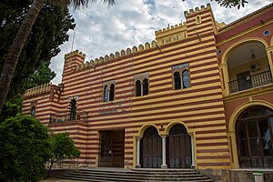
The Palacio de Orleans-Borbón rises in the Spanish town of Sanlucar de Barrameda in the Andalusian province of Cádiz. It was built between 1853 and 1870 as a summer residence for Antoine, Duke of Montpensier and Infanta Luisa Fernanda, Duchess of Montpensier, at the time Duke of Montpensier and Infante of Spain, respectively. Today it is the seat of the municipality of Sanlucar de Barrameda and is known by the name of Town Hall (ayuntamiento).
Weather in this IP's area
clear sky
18 Celsius
18 Celsius
17 Celsius
18 Celsius
1025 hPa
88 %
1025 hPa
1022 hPa
10000 meters
3.6 m/s
310 degree
07:57:37
18:20:56

