185.203.189.134 - IP Lookup: Free IP Address Lookup, Postal Code Lookup, IP Location Lookup, IP ASN, Public IP
Country:
Region:
City:
Location:
Time Zone:
Postal Code:
ISP:
ASN:
language:
User-Agent:
Proxy IP:
Blacklist:
IP information under different IP Channel
ip-api
Country
Region
City
ASN
Time Zone
ISP
Blacklist
Proxy
Latitude
Longitude
Postal
Route
db-ip
Country
Region
City
ASN
Time Zone
ISP
Blacklist
Proxy
Latitude
Longitude
Postal
Route
IPinfo
Country
Region
City
ASN
Time Zone
ISP
Blacklist
Proxy
Latitude
Longitude
Postal
Route
IP2Location
185.203.189.134Country
Region
gelderland
City
nijkerk
Time Zone
Europe/Amsterdam
ISP
Language
User-Agent
Latitude
Longitude
Postal
ipdata
Country
Region
City
ASN
Time Zone
ISP
Blacklist
Proxy
Latitude
Longitude
Postal
Route
Popular places and events near this IP address

Nijkerk
Municipality in Gelderland, Netherlands
Distance: Approx. 1496 meters
Latitude and longitude: 52.23333333,5.48333333
Nijkerk (Dutch pronunciation: [ˈnɛikɛr(ə)k] ; Dutch Low Saxon: Niekark) is a municipality and a city located in the middle of the Netherlands, in the province of Gelderland.

Nijkerkerveen
Village in Gelderland, Netherlands
Distance: Approx. 3083 meters
Latitude and longitude: 52.195,5.46666667
Nijkerkerveen is a village in the Dutch province of Gelderland. It is a part of the municipality of Nijkerk, and lies about 6 km east of Amersfoort. It was first mentioned in 1807 as Nieuwkerker Vheen, and means "bog near Nijkerk".

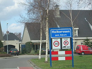
Holkerveen
Hamlet in Gelderland, Netherlands
Distance: Approx. 3320 meters
Latitude and longitude: 52.2,5.45
Holkerveen is a hamlet in the Dutch province of Gelderland. It is a part of the municipality of Nijkerk and lies about six kilometers northeast of Amersfoort. It was first mentioned in 1994 as Holkerveen, and means bog near Holk.

De Veenhuis
Hamlet in Gelderland, Netherlands
Distance: Approx. 3923 meters
Latitude and longitude: 52.21807,5.42866
De Veenhuis is a hamlet in the Dutch province of Gelderland. It is a part of the municipality of Nijkerk, and lies about 6 km north of Amersfoort. It was first mentioned in 1453 as "op Veenhusen", and means "houses on the moorland".

Holk
Hamlet in Gelderland, Netherlands
Distance: Approx. 2490 meters
Latitude and longitude: 52.21666667,5.45
Holk is a hamlet in the Dutch province of Gelderland. It is a part of the municipality of Nijkerk, and lies about 7 km northeast of Amersfoort. It was first mentioned around 1325 as Hollic, and means "low lying neighbourhood".

Doornsteeg
Neighbourhood and Hamlet in Nijkerk, Gelderland, Netherlands
Distance: Approx. 2609 meters
Latitude and longitude: 52.23027,5.4517
Doornsteeg is a neighbourhood of Nijkerk and a hamlet in the Dutch province of Gelderland. It is a part of the municipality of Nijkerk, and lies about 8 km northeast of Amersfoort. It was first mentioned in 1556 as Dorenstege, and means "thorny path".

Slichtenhorst
Hamlet in Gelderland, Netherlands
Distance: Approx. 1764 meters
Latitude and longitude: 52.20442,5.49079
Slichtenhorst is a hamlet in the Dutch province of Gelderland. It is a part of the municipality of Nijkerk, and lies about 8 km east of Amersfoort. It was first mentioned in 1434 as Slichterhorst, and means "flat height with growth".
Driedorp
Hamlet in Gelderland, Netherlands
Distance: Approx. 2679 meters
Latitude and longitude: 52.20663,5.51876
Driedorp is a hamlet in the Dutch province of Gelderland. It is a part of the municipality of Nijkerk, and lies about 10 km east of Amersfoort. It was first mentioned in 1874 as Driedorp and probably means "village of three houses".

Kruishaar
Hamlet in Gelderland, Netherlands
Distance: Approx. 4254 meters
Latitude and longitude: 52.20101,5.54022
Kruishaar is a hamlet in the Dutch province of Gelderland. It is a part of the municipality of Nijkerk, and lies about 11 km east of Amersfoort. A small part belongs to the municipality of Putten.

Amersfoort Vathorst railway station
Railway station in Amersfoort, Netherlands
Distance: Approx. 4711 meters
Latitude and longitude: 52.1925,5.43361111
Amersfoort Vathorst is a railway station on the Utrecht–Kampen railway between Amersfoort and Zwolle. It is located in north Amersfoort, Netherlands. The station is operated by the Nederlandse Spoorwegen (NS).

Nijkerk railway station
Railway station in the Netherlands
Distance: Approx. 539 meters
Latitude and longitude: 52.22194444,5.49333333
Nijkerk is a railway station located in Nijkerk, Netherlands. The station was opened on 20 August 1863 and is located on the Utrecht–Kampen railway (Centraalspoorweg). The services are operated by Nederlandse Spoorwegen.
Putten raid
Distance: Approx. 4484 meters
Latitude and longitude: 52.25,5.53
The Putten raid (Dutch: Razzia van Putten) was a civilian raid conducted by Nazi Germany in occupied Netherlands during the Second World War. On 1 October 1944, a total of 602 men – almost the entire male population of the village – were taken from Putten, in the central Netherlands, and deported to various concentration camps inside Germany. Only 48 returned at the end of the war.
Weather in this IP's area
overcast clouds
5 Celsius
0 Celsius
4 Celsius
6 Celsius
1002 hPa
91 %
1002 hPa
1001 hPa
10000 meters
8.82 m/s
15.47 m/s
211 degree
100 %

